Porto Alegre is the capital and largest city of the Brazilian state of Rio Grande do Sul. Its population of 1.332.845 inhabitants (2022) makes it the 11th-most populous city in the country and the center of Brazil's fifth-largest metropolitan area, with 4,405,760 inhabitants (2010). The city is the southernmost capital city of a Brazilian state.

Sergipe, officially State of Sergipe, is a state of Brazil. Located in the Northeast Region along the Atlantic coast of the country, Sergipe is the smallest state in Brazil by geographical area at 21,910 square kilometres (8,460 sq mi), larger only than the Federal District. Sergipe borders Bahia to the south and west and Alagoas to the north. Aracaju is the capital and the largest city in the state; the state is divided into 75 municipalities. The state has 1.1% of the Brazilian population and produces only 0.6% of the Brazilian GDP.

Uruguaiana is a municipality in the Brazilian state of Rio Grande do Sul. It is located on the eastern shore of the Uruguay River bordering Argentina. Opposite to Uruguaiana, and joined to it by a road/railway bridge, lies the Argentine city of Paso de los Libres, Corrientes. North of Uruguaiana lies the Brazilian municipality of Itaqui, connected by a bridge constructed by the British in 1888 over the Ibicuí River. The municipality also borders the municipalities of Alegrete, Barra do Quaraí and Quaraí, and, also, Uruguay, making it one of the few international triple-border municipalities of Brazil.

Pelotas is a Brazilian city and municipality (município), the fourth most populous in the southern state of Rio Grande do Sul, after Porto Alegre, Caxias do Sul and Canoas. It is located 270 km (168 mi) from Porto Alegre, the state's capital city, and 130 km (80.8 mi) from the Uruguayan border. The Lagoa dos Patos lies to the east and the São Gonçalo Channel lies to the south, separating Pelotas from the city of Rio Grande.

Conceição da Barra is a Brazilian municipality in the state of Espírito Santo. The city is the northernmost coastal city of the state. Its population was 31,273 (2020) and its area is 1,188.044 km².

Santa Maria is a municipality (município) in the central region of Rio Grande do Sul, the southernmost state of Brazil. In 2020, its population was 283,677 inhabitants in a total area of 1,823 square kilometres (704 sq mi). Santa Maria is the 5th biggest municipality in the state, and the largest in its micro-region.
Gravataí is a Brazilian municipality near Porto Alegre at the Rio Grande do Sul State. Its population is approximately 280,000 people, making it the sixth most populous city in the state.

Barreiras is a city located in the west of the state of Bahia, Brazil. It is the most important urban, political, technological and economic center of the western region of the state. Its economy is based on livestock raising and agriculture. In recent years it has experienced an economic boom and is one of the fastest-growing cities in the state of Bahia if not in Brazil.

Campo Bom is a town located in the valley of the Sinos River, in the State of Rio Grande do Sul, Brazil. It belongs to the Greater Porto Alegre area.
Portuguese is the official and national language of Brazil being widely spoken by most of the population. Brazil is the most populous Portuguese-speaking country in the world, with its lands comprising the majority of Portugal's former colonial holdings in the Americas.

Tourism is a growing sector and key to the economy of several regions of Brazil. The country had 6.589 million visitors in 2018, ranking in terms of the international tourist arrivals as the second main destination in South America after Argentina and third in Latin America after Mexico and Argentina. Revenues from international tourists reached US$5.8 billion in 2015, continuing a recovery trend from the 2008–2009 economic crisis.

The climate in Brazil varies considerably from mostly tropical north to temperate zones south of the Tropic of Capricorn.

Ipê is a municipality in the state of Rio Grande do Sul, Brazil. As of 2020, the estimated population was 5,325.

The De Contas River is a river of Bahia state in eastern Brazil. In Portuguese, it is sometimes erroneously called "Rio das Contas". It is the main river of the hydrographic basin named after him.

São Francisco do Conde is a municipality in the state of Bahia in the North-East region of Brazil. São Francisco do Conde covers 262.856 km2 (101.489 sq mi), and has a population of 40,245 with a population density of 150 inhabitants per square kilometer. It is located 67 kilometres (42 mi) from the state capital of Salvador. According to the Brazilian Institute of Geography and Statistics São Francisco do Conde has the highest concentration of Brazilians of African descent (90%) in Bahia.
São Pedro de Alcântara, Santa Catarina is a municipality in the state of Santa Catarina in the South region of Brazil.

Faxinal dos Guedes is a municipality located in the west of the state of Santa Catarina, in the South Region of Brazil. Its population, according to the 2022 Brazilian Institute of Geography and Statistics Census, was 11 192 inhabitants. With an area of 340,070 km2, part of its territory is located on the western edge of a meteoritic crater, the Vargeão Dome.

Events from the year 2004 in Brazil.

Events in the year 1960 in Brazil.
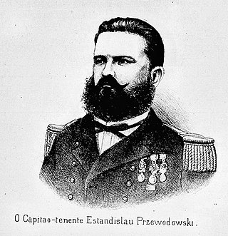
Estanisláo Przewodowski, also known as Estanislau Prezewodowski, was a Brazilian military officer and engineer. A veteran of the Uruguayan and Paraguayan wars, in which he fought for the Imperial Brazilian Navy and received several commendations, later being made commander of the Upper Uruguay Flotilla, based in Itaqui. Occupying this post, he became known for having ordered the bombardment of the Argentine city of Alvear in 1874, causing a diplomatic crisis between the Empire of Brazil and Argentina in reaction to an aggression against a Brazilian doctor by Argentines. Despite being welcomed as a hero by the population of Rio Grande do Sul, he was dismissed from service for participating in the incident, being moved to the reserve with the rank of frigate captain.