Itapetinga

Last updated
Itapetinga, Bahia, Brazil
Municipality
Parque Poliesportivo da Lagoa.jpg
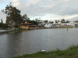
Multisport Park of Pond (Parque Poliesportivo da Lagoa) in June festivities.
Bandeira Municipal de Itapetinga proposta ALFA.jpg
Brasao das Armas Municipais de Itapetinga proposto ALFA..png
Bahia Municip Itapetinga.svg
CountryFlag of Brazil.svg  Brazil
Region Nordeste
State Bahia
Government
  MayorEduardo Hagge
Population
 (2020 [1] )
  Total
76,795
Time zone UTC−3 (BRT)

Itapetinga, Bahia, Brazil is a municipality in the state of Bahia in the North-East region of Brazil. [2] Its population in 2020, according to estimates by the IBGE, was 76,795, so it is the 24th most populous municipality of Bahia. [3] [4]

Contents

Climate

Climate data for Itapetinga, elevation 268 m (879 ft)
MonthJanFebMarAprMayJunJulAugSepOctNovDecYear
Mean daily maximum °C (°F)30.9
(87.6)
31.3
(88.3)
31.2
(88.2)
29.5
(85.1)
27.9
(82.2)
26.6
(79.9)
25.8
(78.4)
26.6
(79.9)
28.0
(82.4)
29.5
(85.1)
29.7
(85.5)
30.3
(86.5)
28.9
(84.0)
Daily mean °C (°F)25.2
(77.4)
25.6
(78.1)
25.7
(78.3)
24.2
(75.6)
22.4
(72.3)
21.4
(70.5)
20.8
(69.4)
21.2
(70.2)
22.5
(72.5)
23.9
(75.0)
24.1
(75.4)
24.7
(76.5)
23.5
(74.3)
Mean daily minimum °C (°F)20.4
(68.7)
20.5
(68.9)
20.7
(69.3)
19.9
(67.8)
18.3
(64.9)
16.9
(62.4)
16.2
(61.2)
16.2
(61.2)
17.5
(63.5)
19.0
(66.2)
19.9
(67.8)
20.3
(68.5)
18.8
(65.8)
Average precipitation mm (inches)111.5
(4.39)
78.6
(3.09)
92.6
(3.65)
69.7
(2.74)
35.9
(1.41)
44.8
(1.76)
44.8
(1.76)
28.5
(1.12)
40.3
(1.59)
89.1
(3.51)
148.2
(5.83)
131.7
(5.19)
914.4
(36.00)
Source: Universidade Federal de Campina Grande [5] [6] [7] [8]

Sister cities

See also

References

  1. IBGE 2020
  2. "Divisão Territorial do Brasil" (in Portuguese). Divisão Territorial do Brasil e Limites Territoriais, Instituto Brasileiro de Geografia e Estatística (IBGE). July 1, 2008. Retrieved December 17, 2009.
  3. "Ranking decrescente do IDH-M dos municípios do Brasil" (in Portuguese). Atlas do Desenvolvimento Humano, Programa das Nações Unidas para o Desenvolvimento (PNUD). 2000. Archived from the original on October 3, 2009. Retrieved December 17, 2009.
  4. "Produto Interno Bruto dos Municípios 2002-2005" (PDF) (in Portuguese). Instituto Brasileiro de Geografia e Estatística (IBGE). December 19, 2007. Archived from the original (PDF) on October 2, 2008. Retrieved December 17, 2009.
  5. "PRECIPITACAO MENSAL - ESTADO DA BAHIA". Departmento de Ciencas Atmosfericas. Archived from the original on February 20, 2018.
  6. "TEMPERATURA MAXIMA MENSAL E ANUAL DA BAHIA". Departmento de Ciencas Atmosfericas. Archived from the original on February 20, 2018.
  7. "TEMPERATURA COMPENSADA MENSAL E ANUAL DA BAHIA". Departmento de Ciencas Atmosfericas. Archived from the original on December 30, 2021.
  8. "TEMPERATURA MINIMA MENSAL E ANUAL DA BAHIA". Departmento de Ciencas Atmosfericas. Archived from the original on December 6, 2021.
  9. Sister Cities International Archived 2008-01-16 at the Wayback Machine

15°15′13″S40°15′20″W / 15.2535°S 40.2555°W / -15.2535; -40.2555