Wanderley, Bahia

Last updated
Wanderley
Municipality
CountryFlag of Brazil.svg  Brazil
Region Nordeste
State Bahia
Population
 (2020 [1] )
  Total12,180
Time zone UTC−3 (BRT)

Wanderley is a municipality in the state of Bahia in the North-East region of Brazil. It has a population of roughly 12000 people. It is very dependent on the agricultural industry in the region with a large portion of the people owning cattle. In the centre of the city there is a church, a market, and an abandoned gas station. It is approximately 2 hours from the main city in the region, Barreiras, and eleven hours driving from the capital of the state Bahia, Salvador. It also 9 hours from the Brazilian capital, Significant Points There are several significant points in Wanderley.

•Praca Do Milho •Panificadora E Mercearia Central  [2]  [3]  [4]  [5] 

See also

Related Research Articles

São Gabriel, Bahia is a municipality in the state of Bahia in the North-East region of Brazil.

Quixabeira Municipality in Nordeste, Brazil

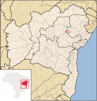
Quixabeira is a municipality in the state of Bahia in the North-East region of Brazil. With 8,956 inhabitants of estimated population, borders with five other municipalities: Jacobina, Capim Grosso, São José do Jacuípe, Várzea da Roça and Serrolândia.

Cordeiros Municipality in Nordeste, Brazil

Cordeiros is a municipality in the state of Bahia in the North-East region of Brazil.

Piripá is a municipality in the state of Bahia in the North-East region of Brazil.

Candiba Municipality in Nordeste, Brazil

Candiba is a municipality in the state of Bahia in the North-East region of Brazil.

Malhada Municipality in Nordeste, Brazil

Malhada is a municipality in the state of Bahia in the North-East region of Brazil.

Palmas de Monte Alto is a municipality in the state of Bahia in the North-East region of Brazil.

Encruzilhada Municipality in Nordeste, Brazil

Encruzilhada is a municipality in the state of Bahia in the North-East region of Brazil.

Abaíra Municipality in Nordeste, Brazil

Abaíra is a municipality in the state of Bahia in the North-East region of Brazil.

Seabra Municipality in Nordeste, Brazil

For people with the surname, see Seabra (surname).

Catolândia Municipality in Nordeste, Brazil

Catolândia is a municipality in the state of Bahia in the North-East region of Brazil.

Mansidão is a municipality in the state of Bahia in the North-East region of Brazil.

São Sebastião do Passé Municipality in Nordeste, Brazil

São Sebastião do Passé is a municipality in the state of Bahia in the North-East region of Brazil.

Muritiba Municipality in Nordeste, Brazil

Muritiba is a municipality in the state of Bahia in the North-East region of Brazil.

Entre Rios, Bahia Municipality in Nordeste, Brazil

Entre Rios is a municipality in the state of Bahia in the North-East region of Brazil.

Abaré is a municipality in the state of Bahia in the North-East region of Brazil.

Buerarema Municipality in Nordeste, Brazil

Buerarema is a municipality in the state of Bahia in the North-East region of Brazil. Your mayor is Mardes Lima Monteiro de Almeida, M.D.

Teofilândia is a municipality in the state of Bahia in the North-East region of Brazil.

Santa Luzia, Bahia Municipality in Nordeste, Brazil

Santa Luzia is a municipality in the state of Bahia in the North-East region of Brazil.

Mairi is a municipality in the state of Bahia in the North-East region of Brazil.

References

  1. IBGE 2020
  2. "Divisão Territorial do Brasil" (in Portuguese). Divisão Territorial do Brasil e Limites Territoriais, Instituto Brasileiro de Geografia e Estatística (IBGE). July 1, 2008. Retrieved December 17, 2009.
  3. "Estimativas da população para 1º de julho de 2009" (PDF) (in Portuguese). Estimativas de População, Instituto Brasileiro de Geografia e Estatística (IBGE). August 14, 2009. Retrieved December 17, 2009.
  4. "Ranking decrescente do IDH-M dos municípios do Brasil" (in Portuguese). Atlas do Desenvolvimento Humano, Programa das Nações Unidas para o Desenvolvimento (PNUD). 2000. Retrieved December 17, 2009.
  5. "Produto Interno Bruto dos Municípios 2002-2005" (PDF) (in Portuguese). Instituto Brasileiro de Geografia e Estatística (IBGE). December 19, 2007. Retrieved December 17, 2009.

Coordinates: 12°07′12″S43°53′16″W / 12.12000°S 43.88778°W / -12.12000; -43.88778