
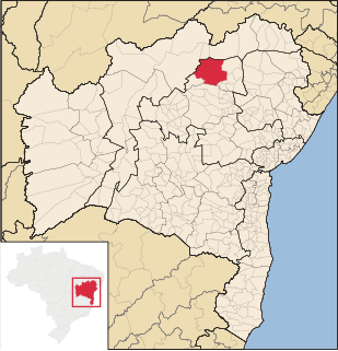
Bahia is one of the 26 states of Brazil and in the northeast of the country, on the Atlantic coast. It is the fourth-largest Brazilian state by population and the 5th-largest by area. Bahia's capital is the city of Salvador, on a spit of land separating the Bay of All Saints from the Atlantic. Once a monarchial stronghold dominated by agricultural, slaving, and ranching interests, Bahia is now still predominantly a working-class industrial and agricultural state. The state is home to 7% of the Brazilian population and produces 4.2% of the country's GDP.

The Bay of All Saints, also known as All Saints' Bay and Todos os Santos Bay, is the principal bay of the Brazilian state of Bahia, to which it gave its name. It sits on the eastern coast of Brazil, surrounding part of Bahia's capital Salvador and opening to the Atlantic Ocean. It covers 1,223 square kilometers (472 sq mi), making it the largest bay in Brazil.

Angra dos Reis is a Brazilian municipality located in the southern part of Rio de Janeiro state. Angra is located at an altitude of 6 meters and includes in its territory many offshore islands, the largest being the Ilha Grande.

Itaparica is an island located at the entrance of Todos os Santos Bay on the coast of the Atlantic Ocean in the state of Bahia, Brazil. It is located about 10 kilometres (6.2 mi) from the city of Salvador, Bahia and covers 146 square kilometres (56 sq mi). There are two municipalities on the island: Vera Cruz and Itaparica (13%). Itaparica has 40 kilometres (25 mi) of beaches and exuberant tropical vegetation. Itaparica is the largest maritime island in Brazil.

Salvador, also known as São Salvador da Bahia de Todos os Santos, is the capital of the Brazilian state of Bahia. With 2.9 million people (2020), it is the largest city proper in the Northeast Region and the 4th largest city proper in the country, after São Paulo, Rio de Janeiro and Brasília.

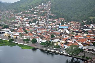
Cachoeira is an inland municipality of Bahia, Brazil, on the Paraguaçu River. The town exports sugar, cotton, and tobacco and is a thriving commercial and industrial centre.
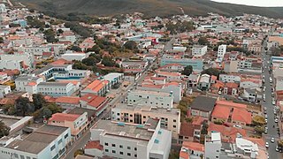
Caetité is a Brazilian municipality in the state of Bahia. It is located in the semi-arid sertão region in the interior of the state. It had an estimated 51,081 inhabitants as of 2020. It covers 2,651.5 square kilometres (1,023.7 sq mi) and is 757 kilometres (470 mi) from the state capital, Salvador. Caetité borders on ten other municipalities, all within Bahia: Igaporã, Guanambi, Pindaí, Licínio de Almeida, Caculé, Ibiassucê, Lagoa Real, Livramento do Brumado, Paramirim, and Tanque Novo.

The Archdiocese of São Salvador da Bahia is part of the Roman Catholic Church in Brazil. The Archbishop of São Salvador da Bahia also carries the title Primate of Brazil. The archdiocese is located in the city of Salvador, Bahia.
Campo Formoso is a municipality in the state of Bahia in the North-East region of Brazil. Campo Formoso covers 7,161.83 km2 (2,765.20 sq mi), and has a population of 71,487 with a population density of 9.2 inhabitants per square kilometer. It is about 248 miles from Bahia's capital Salvador. It is famous for the gems, rare stones and caves that are abundant in the area and it is the host of the cement factory, Cimpor. The city is surrounded by green mountains, and on the edge of one of them there are four transmission towers which allow the population to be connected to the Internet, TV, cable TV, wireless and phone. Campo Formoso has hot weather with temperatures of about 25 °C.
Filadélfia is a municipality in the state of Bahia in the North-East region of Brazil. It has a population of 16,345 as of 2020. It was raised to municipality status in 1985, the area being taken out of the municipality of Pindobaçu.

Vera Cruz (Bahia) is a municipality in the state of Bahia in the North-East region of Brazil. It occupies 87% of the island of Itaparica; the remainder is belongs to the municipality of Itaparica. The municipality of Vera Cruz has a population of is 43,716 and covers an area of 297.537 square kilometres (114.880 sq mi).
Jaguaripe is a municipality in the state of Bahia in the North-East region of Brazil.

Maragogipe is a municipality in the state of Bahia in the North-East region of Brazil. Maragogipe covers 438.18 km2 (169.18 sq mi), and has a population of 44,793 with a population density of 110 inhabitants per square kilometer. Maragogipe is located 130 km (81 mi) from the state capital of Bahia, Salvador. It borders the Paraguaçu River, 20 km (12 mi) upstream from Baía de Todos os Santos. Maragogipe was a major center of sugar cane and tobacco production, and became home to large slave-holding plantations. After the abolition of slavery in Brazil in 1888 the Afro-Brazilian population lived as tenant laborers until recently as "21st century slaves", unable to fish or grow staple crops.
São Félix, Bahia is a municipality in Bahia, Brazil. The municipality has a population of 14,762 with a population density of 142 inhabitants per square kilometer. It is located 110 km (68 mi) from the state capital of Bahia, Salvador.

Cairu is a municipality in the state of Bahia in the North-East region of Brazil. The municipality has a population of 18,427 with a population density of 33.3 inhabitants per square kilometer. The municipality consists of three island: the Island of Cairu, which is only separated from the mainly by a narrow river; Tinharé Island, which has the dense tourist settlement of Morro de São Paulo to the north; and Boipeba Island.
Ilha do cabo Frio Biological Reserve is a municipal biological reserve in the state of Rio de Janeiro, Brazil. It covers an Atlantic island with a unique micro-climate.

The Ilha do Mel State Park is a state park in the state of Paraná, Brazil, located in the municipality of Paranaguá. It is a very small island, with a lot of fauna and flora, due to its small index of urbanization. It has 25 kilometers of beautiful beaches, and the population of the Island is distributed among some small villages: Encantadas, Nova Brasilia, Farol, Praia Grande and Fortaleza.

Ilha dos Frades is an island in the Bay of All Saints. It is administered as part of the city of Salvador in the state of Bahia. The island is located in the center of the bay. It is 6 kilometres (3.7 mi) in length, covers 1.335 hectares, and shaped like a fifteen-pointed star. Ilha dos Frades has preserved vegetation of the Atlantic Forest, including native Brazil wood. The island is protected as part of the Environmental Protection Area of the Bay of All Saints.

The Chapel of Loreto is a 17th-century Roman Catholic church located on the Ilha dos Frades, in the Bay of All Saints, Brazil. The island is within the limits of the municipality of Salvador. The architect Mário Mendonça de Oliveira describes it as "a highly elegant building, with a sophisticated design and an attractive coastal setting on the Island of Frades." The building is protected as a historic structure by the state of Bahia.


