
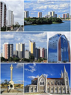
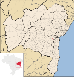
Bahia is one of the 26 states of Brazil and in the northeast of the country, on the Atlantic coast. It is the fourth-largest Brazilian state by population and the 5th-largest by area. Bahia's capital is the city of Salvador, on a spit of land separating the Bay of All Saints from the Atlantic. Once a monarchial stronghold dominated by agricultural, slaving, and ranching interests, Bahia is now still predominantly a working-class industrial and agricultural state. The state is home to 7% of the Brazilian population and produces 4.2% of the country's GDP.

Santo Amaro, also known as Santo Amaro da Purificação is a municipality in the state of Bahia in Brazil. The population is 60,131 in an area of 492.9 square kilometres (190.3 sq mi). It is located in the metropolitan area of Salvador. Santo Amaro is located approximately 73 kilometres (45 mi) from the city of Salvador. Santo Amaro was home to numerous Amerindian peoples until the arrival of the Portuguese, who developed the region for sugarcane production. Santo Amaro is now noted for its numerous historic structures. The city is also a center of Candomblé, having more than 60 terreiros, or temples of the religion.
Petrolina is a municipality located in the southernmost point of the state of Pernambuco, in Northeast Brazil, in the valley of the São Francisco River. The population was 354,317 in 2020, and the total area is 4,756.8 km², making it the largest municipality in the state by area. The municipality is closely integrated with Juazeiro, Bahia, located on the opposite bank of the São Francisco.

Itaparica is an island located at the entrance of Todos os Santos Bay on the coast of the Atlantic Ocean in the state of Bahia, Brazil. It is located about 10 kilometres (6.2 mi) from the city of Salvador, Bahia and covers 146 square kilometres (56 sq mi). There are two municipalities on the island: Vera Cruz and Itaparica (13%). Itaparica has 40 kilometres (25 mi) of beaches and exuberant tropical vegetation. Itaparica is the largest maritime island in Brazil.

Ibotirama is a municipality located in the west of the state of Bahia, Brazil. It is in the micro-region of the lower-middle São Francisco River. This major river passes by the city where it is crossed by a recently constructed bridge. Ibotirama covers 1,740.087 km2 (671.851 sq mi), and has a population of 27,003 with a population density of 16 inhabitants per square kilometer. The municipality lies along the São Francisco River, a major inland water route and the fourth-longest river in Brazil.

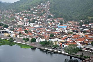
Cachoeira is an inland municipality of Bahia, Brazil, on the Paraguaçu River. The town exports sugar, cotton, and tobacco and is a thriving commercial and industrial centre.
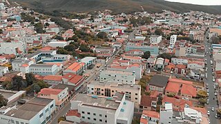
Caetité is a Brazilian municipality in the state of Bahia. It is located in the semi-arid sertão region in the interior of the state. It had an estimated 51,081 inhabitants as of 2020. It covers 2,651.5 square kilometres (1,023.7 sq mi) and is 757 kilometres (470 mi) from the state capital, Salvador. Caetité borders on ten other municipalities, all within Bahia: Igaporã, Guanambi, Pindaí, Licínio de Almeida, Caculé, Ibiassucê, Lagoa Real, Livramento do Brumado, Paramirim, and Tanque Novo.

Itabuna is a municipality in Bahia, Brazil. It is the 6th largest city in Bahia by population after Salvador, Feira de Santana, Camaçari, Vitória da Conquista, and Juazeiro. It had an estimated 213,685 residents in 2020. Itabuna covers a total area of 401 square kilometres (155 sq mi) and has a population density of 550 residents per square kilometer.

Itaparica is a municipality located in the Brazilian island of the same name in the state of Bahia. The municipality covers 13% of the island; the remainder belongs to the municipality of Vera Cruz. The municipality of Itaparica has a population of is 22,337 and covers an area of 115.922 square kilometres (44.758 sq mi).

The Salvador Metro is a rapid transit system serving Salvador city, the state capital of Bahia and the fourth largest city in Brazil. The current system includes a fully open 33 KM and twenty, which began partial public service on June 11, 2014. The system arrives until the center of the city of Lauro de Freitas also. It is operated by CCR METRÔ BAHIA Company.
Cravolândia is a municipality in the state of Bahia in the North-East region of Brazil. Cravolândia covers 182.585 km2 (70.496 sq mi), and has a population of 5,351 with a population density of 31 inhabitants per square kilometer. It borders the municipalities of Santa Inês, Itaquara, Ubaíra and Wenceslau Guimarães. Cravolândia is located 317 kilometres (197 mi) from Salvador, the state capital of Bahia, and is connected to Salvador by federal highways BR-116 and BR-101.

São Francisco do Conde is a municipality in the state of Bahia in the North-East region of Brazil. São Francisco do Conde covers 262.856 km2 (101.489 sq mi), and has a population of 40,245 with a population density of 150 inhabitants per square kilometer. It is located 67 kilometres (42 mi) from the state capital of Salvador. According to the Brazilian Institute of Geography and Statistics São Francisco do Conde has the highest concentration of Brazilians of African descent (90%) in Bahia.

Mata de São João is a municipality in the state of Bahia in the North-East region of Brazil. It covers 605.17 km2 (233.66 sq mi) and a population of 47,126. Mata de São João has a population density of 73 inhabitants per square kilometer. It is located 56 km (35 mi) from the state capital of Bahia, Salvador.

Vera Cruz (Bahia) is a municipality in the state of Bahia in the North-East region of Brazil. It occupies 87% of the island of Itaparica; the remainder is belongs to the municipality of Itaparica. The municipality of Vera Cruz has a population of is 43,716 and covers an area of 297.537 square kilometres (114.880 sq mi).

Maragogipe is a municipality in the state of Bahia in the North-East region of Brazil. Maragogipe covers 438.18 km2 (169.18 sq mi), and has a population of 44,793 with a population density of 110 inhabitants per square kilometer. Maragogipe is located 130 km (81 mi) from the state capital of Bahia, Salvador. It borders the Paraguaçu River, 20 km (12 mi) upstream from Baía de Todos os Santos. Maragogipe was a major center of sugar cane and tobacco production, and became home to large slave-holding plantations. After the abolition of slavery in Brazil in 1888 the Afro-Brazilian population lived as tenant laborers until recently as "21st century slaves", unable to fish or grow staple crops.
São Félix, Bahia is a municipality in Bahia, Brazil. The municipality has a population of 14,762 with a population density of 142 inhabitants per square kilometer. It is located 110 km (68 mi) from the state capital of Bahia, Salvador.

Remanso is located in −9.62, −42 municipality in the state of Bahia in the North-East region of Brazil.

Cairu is a municipality in the state of Bahia in the North-East region of Brazil. The municipality has a population of 18,427 with a population density of 33.3 inhabitants per square kilometer. The municipality consists of three island: the Island of Cairu, which is only separated from the mainly by a narrow river; Tinharé Island, which has the dense tourist settlement of Morro de São Paulo to the north; and Boipeba Island.

Feira da Mata is a municipality in the state of Bahia in the North-East region of Brazil. Feira da Mata covers 1,176.105 km2 (454.097 sq mi), and has a population of 5,661 with a population density of 5 inhabitants per square kilometer. It was originally part of Carinhanha, but became an independent municipality in 1989.

The Birthplace of Cesar Zama is a historic residence in Caetité, Bahia, Brazil. It was listed as a state heritage site by the Institute of Artistic and Cultural Heritage of Bahia in 2008. It is one of the contributing properties to the Historic Center of Caetité, and is noted as the birthplace of César Zama (1837-1906), a Brazilian physician and author. The house covers 412 square metres (4,430 sq ft) and has an upper and lower level with a small attic built on a slope, a model that resembles other houses in Bahia of the same period.


