Multnomah Falls is a waterfall located on Multnomah Creek in the Columbia River Gorge, east of Troutdale, between Corbett and Dodson, Oregon, United States. The waterfall is accessible from the Historic Columbia River Highway and Interstate 84. Spanning two tiers on basalt cliffs, it is the tallest waterfall in the state of Oregon at 620 ft (189 m) in height. The Multnomah Creek Bridge, built in 1914, crosses below the falls, and is listed on the National Register of Historic Places.
The Clatskanie River is a tributary of the Columbia River, approximately 25 miles (40 km) long, in northwestern Oregon in the United States. It drains a timber-producing area in the foothills of the Northern Oregon Coast Range north-northwest of Portland.

Oneonta Gorge is a scenic gorge located in the Columbia River Gorge area of the American state of Oregon. The U.S. Forest Service has designated it as a botanical area because of the unique aquatic and woodland plants that grow there. Exposed walls of 25-million-year-old basalt are home to a wide variety of ferns, mosses, hepatics, and lichens, many of which grow only in the Columbia River Gorge. Oneonta Gorge with its 50 species of wildflowers, flowering shrubs and trees has been described as "one of the true dramatic chasms in the state." The Oneonta Gorge Creek Bridge is listed on the National Register of Historic Places.

Latourell Falls is a waterfall along the Columbia River Gorge in the U.S. state of Oregon, within Guy W. Talbot State Park.

Larch Mountain is an extinct volcano near Portland, Oregon. The name is misleading, as no western larch can be found there. It received that name when early lumbermen sold the noble fir wood as larch. The peak can be reached between May and November on paved Larch Mountain Road, 16 miles (26 km) east of Corbett, Oregon, although the road is closed during the winter and spring months. The road leading to Larch Mountain from the Historic Columbia River Highway is 14 miles long, which closed at milepost 10 from Nov. through late May or early June due to snow.

The Salmon River is a 33.5-mile (53.9 km) river in the Cascade Range in the U.S. state of Oregon that drains part of southwestern Mount Hood. The entire length of the river is a protected National Wild and Scenic River. Several portions are in protected wilderness. It is affluent to the Sandy River, a tributary of the Columbia River.

Silver Falls State Park is a state park in the U.S. state of Oregon, located near Silverton, about 20 miles (32 km) east-southeast of Salem. It is the largest state park in Oregon with an area of more than 9,000 acres (36 km2), and it includes more than 24 miles (39 km) of walking trails, 14 miles (23 km) of horse trails, and a 4-mile (6.4 km) bike path. Its 8.7-mile (14.0 km) Canyon Trail/Trail of Ten Falls runs along the banks of Silver Creek and by ten waterfalls, from which the park received its name. Four of the ten falls have an amphitheater-like surrounding that allows the trail to pass behind the flow of the falls. The Silver Falls State Park Concession Building Area and the Silver Creek Youth Camp-Silver Falls State Park are separately listed on the U.S. National Register of Historic Places.

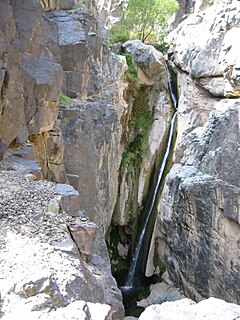
Darwin Falls is a waterfall located on the western edge of Death Valley National Park near the settlement of Panamint Springs, California. Although there exists a similarly named Darwin Falls Wilderness adjacent to the falls, the falls themselves are located in and administered by Death Valley National Park and the National Park Service. There are several falls, but they are mainly divided into the upper and lower, with a small grotto in between. At a combined 80 feet (24 m), it is the highest waterfall in the park. The canyon is walled by dramatic plutonic rock.

Wahclella Falls is a waterfall along Tanner Creek, a tributary of the Columbia River, Multnomah County, Oregon, United States. It enters the river within the Columbia River Gorge.

The Tryon Creek State Natural Area is a state park located primarily in Portland, in the U.S. state of Oregon. It is the only Oregon state park within a major metropolitan area. The 645-acre (261 ha) park lies between Boones Ferry Road and Terwilliger Boulevard in southwest Portland in Multnomah County and northern Lake Oswego in Clackamas County and is bisected from north to south by Tryon Creek. To the north, the park abuts the Lewis & Clark Law School campus.

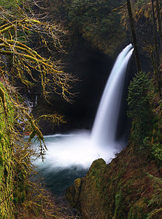
Metlako Falls is a waterfall on Eagle Creek in the Columbia River Gorge National Scenic Area in Hood River County, Oregon, United States. It is the furthest downstream of the major waterfalls on Eagle Creek. Like upstream Punch Bowl Falls, Metlako is also in the form of a punchbowl. The falls is 31 meters (101 ft) tall, though people have measured it anywhere from 30 to 46 m tall. It is the upstream limit for salmon spawning in Eagle Creek.

Munson Creek Falls State Natural Site is a state park in the U.S. state of Oregon, administered by the Oregon Parks and Recreation Department. The park contains Munson Creek Falls, which is the tallest waterfall in Oregon's Coast Range. A short hike of 0.5 miles (0.80 km) leads to views of the 319 feet (97 m) waterfall.

Salt Creek Falls is a cascade and plunge waterfall on Salt Creek, a tributary of the Middle Fork Willamette River, that plunges into a gaping canyon in the Willamette National Forest near Willamette Pass in Lane County, Oregon. The waterfall is notable for its main drop of 286 feet (87 m), ranking third highest among plunge waterfalls in Oregon, after Multnomah Falls and Watson Falls.) The pool at the bottom of Salt Creek Falls waterfall is 66 feet (20 m) deep.

Hedge Creek Falls is a waterfall on Hedge Creek, in the Shasta Cascade area in Dunsmuir, California. There is a small cave located behind the waterfall, allowing visitors to walk behind the cascading water. Shortly after the waterfall, hedge creek flows into the Sacramento River south of Mossbrae Falls. There is a viewing platform over the river, with a view of Mount Shasta. Access to the waterfall and viewing platform is via a short hiking trail. The trail starts at a small park off the Dunsmuir Ave/Siskiyou Ave exit on Interstate 5. The waterfall is 0.2 miles (0.32 km) down Hedge Creek Falls Trail. The close proximity to Interstate 5, makes the waterfall a very popular stopping point for passing motorists.

North Falls is a waterfall located in the Silver Falls State Park at the east end of the city of Salem, in Marion County, in the U.S. state of Oregon. It is located in a privileged area on the west foothills where Mount Hood National Forest meets with the Middle Santiam Wilderness. Several prominent waterfalls are located in the Park along Trail of Ten Falls: South Falls, Drake Falls, Lower South Falls, and Winter Falls—among others.

Twin Falls is a waterfall located in the Silver Falls State Park at the east end of the city of Salem, in Marion County, in the U.S. state of Oregon. It is located in the west foothills where Mount Hood National Forest meets with the Middle Santiam Wilderness. Several prominent waterfalls are located in the Park along Trail of Ten Falls: South Falls, Drake Falls, Lower South Falls, and Winter Falls—among others.

Beaver Creek Falls is a small waterfall located at the confluence of Beaver and Sweet Creeks in Lane County, in the U.S. state of Oregon. The waterfall is known for joining of the two creeks becoming one intertwined waterfall.

Diamond Creek Falls is a waterfall formed along Gibson Canyon on the north end of Willamette National Forest, east side of the city of Oakridge in Lane County, Oregon. Access to Diamond Creek Falls is located along Oregon Route 58 through trail paths that lead down to the stream and the base of the waterfall.
Drift Creek Falls is a waterfall formed west of Valley of the Giants, east side of the city of Lincoln City in Lincoln County, Oregon. Access to Drift Creek Falls is located along a trail constructed by the Forest Service in the 1990s and features a 240 foot long suspension bridge crossing Drift Creek.

Eagle Creek Upper Falls, also called Upper Eagle Creek Falls, is a small waterfall located in Clackamas County, in the U.S. state of Oregon. The waterfall is known for a fish ladder that bypasses the waterfall to assist fish navigate the waterfall. Eagle Creek is known for being a point for fishing chinook salmon, bull trout, and steelhead trout.


