Bedford Castle

Last updated

Bedford Castle
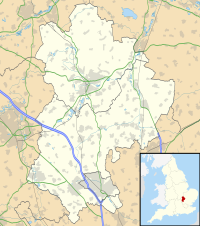
Bedford, Bedfordshire, England
Castle Hill, Bedford - geograph.org.uk - 646086.jpg
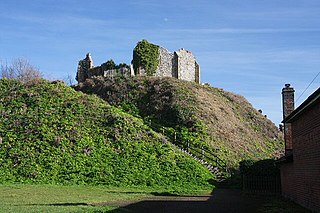
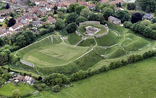
Remaining motte of Bedford Castle
Bedfordshire UK location map.svg
Red pog.svg
Bedford Castle
Coordinates 52°08′07″N0°27′48″W / 52.13539°N 0.46333°W / 52.13539; -0.46333
Grid reference grid reference TL052496
Type Motte and bailey
Site information
ConditionDestroyed, part of motte remains
Site history
MaterialsStone

Bedford Castle was a large medieval castle in Bedford, England. Built after 1100 by Henry I, the castle played a prominent part in both the civil war of the Anarchy and the First Barons' War. The castle was significantly extended in stone, although the final plan of the castle remains uncertain. Henry III of England besieged the castle in 1224 following a disagreement with Falkes de Bréauté; the siege lasted eight weeks and involved an army of as many as 2,700 soldiers with equipment drawn from across England. After the surrender of the castle, the king ordered its destruction (slighting).

Contents

Although partially refortified in the 17th century during the English Civil War, the castle remained a ruin until the urban expansion in Bedford during the 19th century, when houses were built across much of the property. Today only part of the motte still stands, forming part of an archaeological park built on the site between 2007 and 2009.

History

Early history (1100–1153)

Bedford Castle was probably built after 1100 by Henry I in the town of Bedford, overlooking the River Great Ouse. The castle was constructed inside the town itself, and many of the older Anglo-Saxon streets had to be destroyed and diverted to make room for it, leaving a permanent mark in the formal grid system. [1] The castle was built in a motte and bailey design and was probably much smaller than the later castle, just consisting of the motte and the inner bailey. [2]

By the early 12th century the castle was controlled by the royal castellan, Simon de Beauchamp, the son of Hugh de Beauchamp who had helped conquer England in 1066. [3] Contemporaries described the castle around this time as "completely ramparted around with an immense earthen bank and ditch, girt about with a wall strong and high, strengthened with a strong and unshakeable keep". [4] Simon died in 1137, and King Stephen agreed that Simon's daughter should marry Hugh the Pauper and that the castle would be given to Hugh, in exchange for Stephen giving Miles compensatory honours and gifts. [5] Miles and Payn de Beauchamp, the children of Simon's brother, Robert de Beauchamp, declared that the castle was rightfully Miles' and refused to hand it over to Hugh. [6]

A reconstruction of how Bedford Castle may possibly have appeared in 1224; A - inner bailey; B - keep; C - moat, fed by the River Great Ouse; D - outer bailey; E - gatehouse Bedford Castle labelled.png
A reconstruction of how Bedford Castle may possibly have appeared in 1224; A – inner bailey; B – keep; C – moat, fed by the River Great Ouse; D – outer bailey; E – gatehouse

Meanwhile, civil war had broken out in England between King Stephen and the Empress Matilda, resulting in a period of chaos known as the Anarchy. Matilda's uncle, David I of Scotland, invaded England during 1137 in support of her claim. [7] Although Miles de Beauchamp declared himself in support of Stephen, the king decided to retake Bedford Castle before marching north. [6] Stephen formed an army to besiege Bedford Castle but Miles gained advance warning of the attack and took in considerable supplies, preparing for a long siege. [7] Stephen was unable to storm the castle and left a force under the command of Hugh to starve it into submission whilst he marched north to tackle the Scots invasion. [8]

Henry of Blois, the Bishop of Winchester, intervened in an attempt to produce a negotiated solution. [6] Henry reached an agreement whereby after five weeks, the castle finally surrendered; the garrison were allowed to leave peacefully but the castle was handed over to the king. [9] The deal struck by Miles and Henry appears to have left the surrounding estates in the hands of the Beauchamps, however, and in 1141 Miles returned and retook the castle itself, although no details are available as to how he achieved this. [10]

Miles subsequently supported the Empress, and in 1146, Ranulf, the Earl of Chester and temporarily on the side of the king, attacked and took the town of Bedford, but was unable to take the castle, which continued to be controlled by Miles until his death several years later. [11] Towards the end of the war, Bedford Castle may have been attacked again; Henry II, during the final year of the conflict in 1153, marched through Bedford and documentary evidence shows damage to the town at this time. Historians are divided as to whether the castle was besieged at the same time. [12] [nb 2]

Mid-medieval period (1153–1224)

The medieval lime kiln preserved as part of the archaeological park at Bedford Castle BedfordLimeKiln.JPG
The medieval lime kiln preserved as part of the archaeological park at Bedford Castle

Early in 1215 tensions grew between King John and a rebel faction of his barons, which would lead to the First Barons' War. [13] The rebel barons attempted to besiege Northampton Castle; unsuccessful, they turned to Bedford Castle but the castle withstood the attack and they moved south to London. [13] Bedford was held at the time by William de Beauchamp but his loyalty came into question and he rebelled against John. [14] Falkes de Breauté, a key Anglo-Norman leader loyal to John, resisted and seized Bedford Castle back for John in 1216. [15] In return John gave Falkes the Honour of Bedford, and in practical terms the castle as well, although it is unclear whether he gave Falkes the role of castellan or ownership of the castle itself. [15] [nb 3] As the war continued, Falkes took control of Plympton, Christchurch and Carisbrooke castles, whilst continuing to hold onto Bedford. [17] After the death of King John in 1216 the war turned against the rebel barons and the royalist faction, including Falkes, was able to restore his son, the young Henry III to power in England.

After the war, Falkes made Bedford Castle his headquarters and he expanded it considerably, resulting in what David Baker has described as a "major refortification". [18] Falkes destroyed the neighbouring churches of St Paul's and St Cuthbert's to make space for a new bailey, reusing the stone for the castle. [19] The exact form of the castle after this expansion remains uncertain. The castle appears to have been quadrangular, with the western edge running along the rear of the modern High Street and the northern edge running along the modern roads of Ram Yard and Castle Lane. [20] The castle had a new barbican; an outer and an inner bailey, with the inner bailey in the south-east corner, protected by an internal ditch and a stone-lined palisade; further stone lined ditches lay around the castle; and a new keep was built on the motte. [21] Brown suspects that the new keep was probably a shell keep with a tower, similar to those built at Launceston or Bungay. [22] The stone-lined palisades and ditches built at Bedford were very unusual in England – their closest equivalent are those found at Skenfrith Castle in Wales. [23] The castle had a postern watergate facing towards the river, and a great hall within the inner bailey in the middle, at least 13 m (43 feet) wide and 40 m (131 feet) long. [24] There was possibly a large stone gatehouse positioned on the outer bailey wall. [23] A mound in the north-east corner of the castle probably supported a large tower. [20]

Siege of 1224

Mangonel shot, discovered at the castle in the 1970s and probably dating from the 1224 siege MangonelShotBedfordMuseum.JPG
Mangonel shot, discovered at the castle in the 1970s and probably dating from the 1224 siege

Henry III decided that Bedford Castle should be returned to its original owner, William de Beauchamp, and became increasingly frustrated with Falkes' refusal to do so; matters came to a head when Falkes' castellans imprisoned Henry of Braybrooke, a royal judge who was hearing law cases against Falkes. [26] When Falkes refused to release the judge, Henry mobilised an army, supported by the Church in the form of Stephen Langton, the Archbishop of Canterbury, and advanced to Bedford. [27] [nb 4] Falkes had left the castle, along with around eighty men, in charge of his brother, William de Breauté, who refused to surrender it to the king. [29] Falkes was probably hoping that if the castle held on long enough, his efforts to convince Pope Honorius III to intervene against Henry would succeed. [29] The Archbishop excommunicated William and the siege began. [26] [nb 5]

The siege of Bedford Castle required huge resources. [31] Siege engines were brought from Lincoln, Northampton and Oxfordshire, while carpenters built others on site using timber from Northamptonshire; ropes from London, Cambridge and Southampton; hides from Northampton and tallow from London. [31] Labourers from across Bedfordshire and Northamptonshire were gathered by the relevant sheriffs, and miners from Hereford and the Forest of Dean. [32] Crossbow bolts were ordered from a depot at Corfe Castle and from the provinces; 43,300 crossbow bolts are known to have been ordered by the king. [33] Local trees were cut down, and stone quarrying begun to provide ammunition for siege engines. [34] Tents and pavilions for the King were sent from London along with supplies of luxury foods and wine, also for the King. [32] In total, Henry's wage bill for the siege came to £1,311; [nb 6] it is uncertain exactly how large Henry's army was, but potentially there were between 1,600 and 2,700 men present at any one time. [36] To support the siege, Langton instructed his bishops to mobilise one man from every 24 hectares (60 acres) of land they owned and levied a special tax on the churches' estates. [37]

A near-contemporary sketch by Matthew Paris of the keep and tower of Bedford Castle (l) during the 1224 siege, and the execution of the garrison after their surrender (r) BitvauBedfordu1224.jpg
A near-contemporary sketch by Matthew Paris of the keep and tower of Bedford Castle (l) during the 1224 siege, and the execution of the garrison after their surrender (r)

With these resources, Henry erected a number of siege engines around the castle; one probable trebuchet and two mangonels were set up to the east of the castle; two mangonels were placed on the west side, to attack the keep, and one mangonel on both the north and south sides. [26] [nb 7] Two siege-castles were established to observe the occupants of the castle. [26] William was confident, however, that either his brother would return and relieve the siege, or that the pope would intervene, and held on despite the artillery attacks. [29] The losses in the royal army began to mount; chronicler Ralph of Coggeshall suggests that seven knights, and over 200 soldiers and labourers were killed as the siege dragged on. [39]

Bedford Castle finally fell through a sequence of four attacks. [22] Royal forces first captured the barbican and then stormed the outer bailey, seizing most of the castle's supplies but taking considerable losses. [22] Miners, operating under the protection of a "cat", then gained access to the inner bailey by collapsing part of the wall. [40] [nb 8] Finally, on 14 August, the miners attacked the keep itself, lighting a fire under the walls, cracking the stone and filling the building with smoke. [40] The female members of the household, including Falkes' wife, and Henry de Braybrooke were released, the royal standard was raised over the tower, and the next day William and the garrison surrendered. [40]

A discussion ensued about the fate of the garrison; near contemporary accounts suggest that the prisoners asked the Archbishop for assistance, but that this was declined. [40] Henry then had all the male members of the garrison hanged, except for three knights who agreed to join the military order of the Knights Templar. [41] Three days after the fall of Bedford Castle, the Pope wrote a letter demanding that Henry cease his campaign against Falkes, but this intervention had occurred far too late to be of use. [42] Alexander de Stavenby, the Bishop of Coventry, convinced Falkes to surrender after the fall of the castle; he handed over his remaining castles at Plympton and Storgursey and was absolved by Langton, going into exile shortly afterwards. [43] Historian R. Brown has noted that the 1224 siege of Bedford Castle was remarkable in that the castle's garrison was able to hold out against "the concentrated military resources of the whole kingdom" for an impressive eight weeks. [44] David Carpenter argues that the fall of Bedford castle "concluded the triumph of central government" over the previously uncontrollable forces of the local barons. [45]

Later history (13–19th centuries)

Bedford Castle in John Speed's map of 1611, showing the motte and remaining fragments of the bailey walls Bedford Castle - Speed map.jpg
Bedford Castle in John Speed's map of 1611, showing the motte and remaining fragments of the bailey walls

After the siege Henry III ordered the castle to be dismantled, and labourers filled in the ditches and halved the height of the stone walls. [46] William de Beauchamp was forbidden to rebuild the castle, and instead built an unfortified house in the inner bailey. [20] St Paul's and St Cuthbert's churches were rebuilt in 1224 using stone from the castle. [47] The sudden availability of cheap stone led to the repaving of many of the town streets in Bedford in 1224. [48] Local tradition suggests that the first stone bridge at Bedford, the Great Bridge, was built using stone from the castle. [49] By 1361 the castle site was described as "a void plot of old enclosed by walls" and seems to have been derelict for most of the medieval period. [50] The antiquarian John Leland visited the site in the 16th century, and noted that the castle was "now clean down". [51] The early 17th-century mapmaker John Speed produced a map of Bedford in 1611, showing the motte and a fragment of bailey wall still standing on an otherwise vacant site. [52]

At the outbreak of the English Civil War, Bedford sided with Parliament; the town was temporarily captured by Prince Rupert of the Rhine in 1643 and the castle was refortified for the duration of the war. [53] A probable wooden fort and prison were built on the remains of the motte and defended by a hundred-man garrison. [54] After the war the motte became used as a bowling green until the 19th century. [54] In 1804 the north-east tower of the castle was turned into a hexagonal building for the local militia unit. [55] Bedford began to spread eastwards in the late 19th century and the castle baileys became desirable property for housing; in 1851 the last parts of the barbican were destroyed to make way for the construction of cottages. [56]

In 2004 Bedford Borough Council commissioned artist Gary Drostle to create a mosaic map of Bedford depicting the medieval history of the town. The Bedford snakes - geograph.org.uk - 552611.jpg
In 2004 Bedford Borough Council commissioned artist Gary Drostle to create a mosaic map of Bedford depicting the medieval history of the town.

Modern period (20–21st centuries)

Today only the base of the motte survives at Bedford Castle, 7.5 m (25 feet) high and 49 m (161 feet) wide at the top, and is a scheduled monument. Archaeological work has been conducted to develop a better understanding of the history of the castle, although excavations are difficult because of the urban nature of the site. [23] Excavations between 1969 and 1972 established the broad form of the castle; this was supplemented by further work in 1995–6 and another phase of excavations in 2007. [57] Following the 2007 investigations, an archaeological park was built on part of the castle site between 2007 and 2009, forming the centre of a mixed-use development of restaurants and apartments. [58] The park incorporated one of the castle's lime kilns, first rediscovered in 1973, and the foundations of a hall discovered at the castle. [58]

In 2004 Bedford Borough Council commissioned artist Gary Drostle to create a mosaic map of Bedford depicting the castle and Bedford's medieval history in front of the castle mound. [59]

See also

Notes

  1. The exact layout of Bedford Castle in 1224 remains uncertain; the model depicted here predates the archaeological excavations in 2007.
  2. The events of 1153 at Bedford Castle are unclear. Jim Bradbury interprets the damage to the town as suggesting a failed attack on the castle, implying that the pro-Angevin de Beauchamps were no longer in control of it. David Baker and W. L. Warren suggest an attack on the town occurred, but make no suggestion that the castle was attacked, which would allow for continued pro-Angevin control of the fortification itself. [12]
  3. Nigel Pounds argues the legal status of the castle at this time was unclear, and that it may have formed part of the Honour of Bedford as a baronial castle; David Baker suspects that it had remained a royal castle. [16]
  4. Historian Emilie Amt notes that Falkes' timing was "almost comically inept", since the king was already gathered with his barons to hold court at Northampton, only a few miles away. [28]
  5. The 1224 siege is unusually well documented by medieval standards, due to the local annalists at Dunstable Priory who recorded the events in some detail. [30]
  6. It is impossible to accurately compare 13th century and modern prices or incomes. For comparison, £1,311 is almost seven times the annual income of an average baron of the period. [35]
  7. The historical accounts are unclear as to exactly what siege artillery was used at Bedford: the medieval terminology applied to these weapons was vague. Historian Emilie Amt argues that the quantities of rope and manpower required for the engines may imply that the mangonels were in fact what we would today call traction trebuchets. [38]
  8. R. Brown believes that this phase of the operations refers instead to Henry's forces gaining access to the shell keep. [22]

Related Research Articles

<span class="mw-page-title-main">Castle</span> Fortified residential structure of medieval Europe

A castle is a type of fortified structure built during the Middle Ages predominantly by the nobility or royalty and by military orders. Scholars usually consider a castle to be the private fortified residence of a lord or noble. This is distinct from a mansion, palace and villa, whose main purpose was exclusively for pleasance and are not primarily fortresses but may be fortified. Use of the term has varied over time and, sometimes, has also been applied to structures such as hill forts and 19th- and 20th-century homes built to resemble castles. Over the Middle Ages, when genuine castles were built, they took on a great many forms with many different features, although some, such as curtain walls, arrowslits, and portcullises, were commonplace.

<span class="mw-page-title-main">Castle Rising Castle</span> 12th-century castle in Norfolk, England

Castle Rising is a ruined medieval fortification in the village of Castle Rising, Norfolk, England. It was built soon after 1138 by William d'Aubigny II, who had risen through the ranks of the Anglo-Norman nobility to become the Earl of Arundel. With his new wealth, he constructed Castle Rising and its surrounding deer park, a combination of fortress and palatial hunting lodge. It was inherited by William's descendants before passing into the hands of the de Montalt family in 1243. The Montalts later sold the castle to Queen Isabella, who lived there after her fall from power in 1330. Isabella extended the castle buildings and enjoyed a regal lifestyle, entertaining her son, Edward III, on several occasions. After her death, it was granted to Edward, the Black Prince, to form part of the Duchy of Cornwall.

<span class="mw-page-title-main">Framlingham Castle</span> Historic castle in Framlingham, England

Framlingham Castle is a castle in the market town of Framlingham, Suffolk, England. An early motte and bailey or ringwork Norman castle was built on the Framlingham site by 1148, but this was destroyed (slighted) by Henry II of England in the aftermath of the Revolt of 1173–1174. Its replacement, constructed by Roger Bigod, the Earl of Norfolk, was unusual for the time in having no central keep, but instead using a curtain wall with thirteen mural towers to defend the centre of the castle. Despite this, the castle was successfully taken by King John in 1216 after a short siege. By the end of the 13th century, Framlingham had become a luxurious home, surrounded by extensive parkland used for hunting.

<span class="mw-page-title-main">Castles in Great Britain and Ireland</span>

Castles have played an important military, economic and social role in Great Britain and Ireland since their introduction following the Norman invasion of England in 1066. Although a small number of castles had been built in England in the 1050s, the Normans began to build motte and bailey and ringwork castles in large numbers to control their newly occupied territories in England and the Welsh Marches. During the 12th century the Normans began to build more castles in stone – with characteristic square keep – that played both military and political roles. Royal castles were used to control key towns and the economically important forests, while baronial castles were used by the Norman lords to control their widespread estates. David I invited Anglo-Norman lords into Scotland in the early 12th century to help him colonise and control areas of his kingdom such as Galloway; the new lords brought castle technologies with them and wooden castles began to be established over the south of the kingdom. Following the Norman invasion of Ireland in the 1170s, under Henry II, castles were established there too.
<span class="mw-page-title-main">Warwick Castle</span> Medieval motte-and-bailey castle in Warwickshire, England

Warwick Castle is a medieval castle developed from a wooden fort, originally built by William the Conqueror during 1068. Warwick is the county town of Warwickshire, England, situated on a meander of the River Avon. The original wooden motte-and-bailey castle was rebuilt in stone during the 12th century. During the Hundred Years War, the facade opposite the town was refortified, resulting in one of the most recognisable examples of 14th-century military architecture. It was used as a stronghold until the early 17th century, when it was granted to Sir Fulke Greville by James I in 1604. Greville converted it to a country house, and it was owned by the Greville family until 1978, when it was bought by the Tussauds Group.
<span class="mw-page-title-main">York Castle</span> Grade I listed monument in York, England

York Castle is a fortified complex in the city of York, England. It consists of a sequence of castles, prisons, law courts and other buildings, which were built over the last nine centuries on the south side of the River Foss. The now ruined keep of the medieval Norman castle is commonly referred to as Clifford's Tower. Built originally on the orders of William I to dominate the former Viking city of Jórvík, the castle suffered a tumultuous early history before developing into a major fortification with extensive water defences. After a major explosion in 1684 rendered the remaining military defences uninhabitable, York Castle continued to be used as a gaol and prison until 1929.

<span class="mw-page-title-main">Motte-and-bailey castle</span> Medieval fortification

A motte-and-bailey castle is a European fortification with a wooden or stone keep situated on a raised area of ground called a motte, accompanied by a walled courtyard, or bailey, surrounded by a protective ditch and palisade. Relatively easy to build with unskilled labour, but still militarily formidable, these castles were built across northern Europe from the 10th century onwards, spreading from Normandy and Anjou in France, into the Holy Roman Empire, as well as the Low Countries it controlled, in the 11th century, when these castles were popularized in the area that became the Netherlands. The Normans introduced the design into England and Wales. Motte-and-bailey castles were adopted in Scotland, Ireland, and Denmark in the 12th and 13th centuries. By the end of the 13th century, the design was largely superseded by alternative forms of fortification, but the earthworks remain a prominent feature in many countries.

<span class="mw-page-title-main">Keep</span> Fortified tower built in the Middle Ages

A keep is a type of fortified tower built within castles during the Middle Ages by European nobility. Scholars have debated the scope of the word keep, but usually consider it to refer to large towers in castles that were fortified residences, used as a refuge of last resort should the rest of the castle fall to an adversary. The first keeps were made of timber and formed a key part of the motte-and-bailey castles that emerged in Normandy and Anjou during the 10th century; the design spread to England, Portugal, south Italy and Sicily. As a result of the Norman invasion of 1066, use spread into Wales during the second half of the 11th century and into Ireland in the 1170s. The Anglo-Normans and French rulers began to build stone keeps during the 10th and 11th centuries, including Norman keeps, with a square or rectangular design, and circular shell keeps. Stone keeps carried considerable political as well as military importance and could take a decade or more to build.

<span class="mw-page-title-main">Oxford Castle</span> Partly ruined castle in Oxford in Oxfordshire, England

Oxford Castle is a large, partly ruined medieval castle on the western side of central Oxford in Oxfordshire, England. Most of the original moated, wooden motte and bailey castle was replaced in stone in the late 12th or early 13th century and the castle played an important role in the conflict of the Anarchy. In the 14th century the military value of the castle diminished and the site became used primarily for county administration and as a prison. The surviving rectangular St George's Tower is now believed to pre-date the remainder of the castle and be a watch tower associated with the original Saxon west gate of the city.

<span class="mw-page-title-main">Cambridge Castle</span> Castile in Cambridge, England

Cambridge Castle, locally also known as Castle Mound, is located in Cambridge, Cambridgeshire, England. Originally built after the Norman conquest to control the strategically important route to the north of England, it played a role in the conflicts of the Anarchy, the First and Second Barons' Wars. Hugely expanded by Edward I, the castle then fell rapidly into disuse in the late medieval era, its stonework recycled for building purposes in the surrounding colleges. Cambridge Castle was refortified during the English Civil War but once again fell into disuse, used primarily as the county gaol. The castle gaol was finally demolished in 1842, with a new prison built in the castle bailey. This prison was demolished in 1932, replaced with the modern Shire Hall, and only the castle motte and limited earthworks still stand. The site is open to the public daily and offers views over the historic buildings of the city.
<span class="mw-page-title-main">Wallingford Castle</span> Ruined castle in Oxfordshire, England

Wallingford Castle was a major medieval castle situated in Wallingford in the English county of Oxfordshire, adjacent to the River Thames. Established in the 11th century as a motte-and-bailey design within an Anglo-Saxon burgh, it grew to become what historian Nicholas Brooks has described as "one of the most powerful royal castles of the 12th and 13th centuries". Held for the Empress Matilda during the civil war years of the Anarchy, it survived multiple sieges and was never taken. Over the next two centuries it became a luxurious castle, used by royalty and their immediate family. After being abandoned as a royal residence by Henry VIII, the castle fell into decline. Refortified during the English Civil War, it was eventually slighted, i.e. deliberately destroyed, after being captured by Parliamentary forces after a long siege. The site was subsequently left relatively undeveloped, and the limited remains of the castle walls and the considerable earthworks are now open to the public.
<span class="mw-page-title-main">Castle Acre Castle and town walls</span> Grade I listed castle in United Kingdom

Castle Acre Castle and town walls are a set of ruined medieval defences built in the village of Castle Acre, Norfolk. The castle was built soon after the Norman Conquest by William de Warenne, the Earl of Surrey, at the intersection of the River Nar and the Peddars Way. William constructed a motte-and-bailey castle during the 1070s, protected by large earthwork ramparts, with a large country house in the centre of the motte. Soon after, a small community of Cluniac monks were given the castle's chapel in the outer bailey; under William, the second earl, the order was given land and estates to establish Castle Acre Priory alongside the castle. A deer park was created nearby for hunting.

<span class="mw-page-title-main">Clare Castle</span> Castle in Suffolk, England

Clare Castle is a high-mounted ruinous medieval castle in the parish and former manor of Clare in Suffolk, England, anciently the caput of a feudal barony. It was built shortly after the Norman Conquest of England in 1066 by Richard Fitz Gilbert, having high motte and bailey and later improved in stone. In the 14th century it was the seat of Elizabeth de Clare, one of the wealthiest women in England, who maintained a substantial household there. The castle passed into the hands of the Crown and by 1600 was disused. The ruins are an unusually tall earthen motte surmounted by tall remnants of a wall and of the round tower, with large grassland or near-rubble gaps on several of their sides. It was damaged by an alternate line of the Great Eastern Railway in 1867, the rails of which have been removed.

<span class="mw-page-title-main">Eye Castle</span> Castle in Suffolk

Eye Castle is a motte and bailey medieval castle with a prominent Victorian addition in the town of Eye, Suffolk. Built shortly after the Norman conquest of England in 1066, the castle was sacked and largely destroyed in 1265. Sir Edward Kerrison built a stone house on the motte in 1844: the house later decayed into ruin, becoming known as Kerrison's Folly in subsequent years.

<span class="mw-page-title-main">Thetford Castle</span> 11th-century castle in Thetford, England

Thetford Castle is a medieval motte and bailey castle in the market town of Thetford in the Breckland area of Norfolk, England. The first castle in Thetford, a probable 11th-century Norman ringwork called Red Castle, was replaced in the 12th century by a much larger motte and bailey castle on the other side of the town. This new castle was largely destroyed in 1173 by Henry II, although the huge motte, the second largest man-made mound in England, remained intact. The motte, recognised as a scheduled monument, now forms part of a local park, and the remains are known variously as Castle Hill, Castle Mound and Military Parade.

<span class="mw-page-title-main">Corfe Castle</span> 11th-century castle in Dorset, England

Corfe Castle is a fortification standing above the village of the same name on the Isle of Purbeck peninsula in the English county of Dorset. Built by William the Conqueror, the castle dates to the 11th century and commands a gap in the Purbeck Hills on the route between Wareham and Swanage. The first phase was one of the earliest castles in England to be built at least partly using stone when the majority were built with earth and timber. Corfe Castle underwent major structural changes in the 12th and 13th centuries.

<span class="mw-page-title-main">Worcester Castle</span> Norman fortification built between 1068 and 1069 in Worcester, England

Worcester Castle was a Norman fortification built between 1068 and 1069 in Worcester, England by Urse d'Abetot on behalf of William the Conqueror. The castle had a motte-and-bailey design and was located on the south side of the old Anglo-Saxon city, cutting into the grounds of Worcester Cathedral. Royal castles were owned by the king and maintained on his behalf by an appointed constable. At Worcester that role was passed down through the local Beauchamp family on a hereditary basis, giving them permanent control of the castle and considerable power within the city. The castle played an important part in the wars of the 12th and early 13th century, including the Anarchy and the First Barons' War.

<span class="mw-page-title-main">Berkhamsted Castle</span> Norman castle in Hertfordshire, UK

Berkhamsted Castle is a Norman motte-and-bailey castle in Berkhamsted, Hertfordshire. The castle was built to obtain control of a key route between London and the Midlands during the Norman conquest of England in the 11th century. Robert of Mortain, William the Conqueror's half brother, was probably responsible for managing its construction, after which he became the castle's owner. The castle was surrounded by protective earthworks and a deer park for hunting. The castle became a new administrative centre of the former Anglo-Saxon settlement of Berkhamsted. Subsequent kings granted the castle to their chancellors. The castle was substantially expanded in the mid-12th century, probably by Thomas Becket.

<span class="mw-page-title-main">Southampton Castle</span> Castle in Southampton, England

Southampton Castle was located in the town of Southampton in Hampshire, England. Constructed after the Norman conquest of England, it was located in the north-west corner of the town overlooking the River Test, initially as a wooden motte and bailey design. By the late 12th century the royal castle had been largely converted to stone, playing an important part in the wine trade conducted through the Southampton docks. By the end of the 13th century the castle was in decline, but the threat of French raids in the 1370s led Richard II to undertake extensive rebuilding. The result was a powerfully defended castle, one of the first in England to be equipped with cannon. The castle declined again in the 16th century and was sold off to property speculators in 1618. After being used for various purposes, including the construction of a Gothic mansion in the early 19th century, the site was flattened and largely redeveloped. Only a few elements of the castle still remain visible in Southampton.

References

  1. Creighton, p. 40, 141.
  2. Baker, p. 18; Albion Archaeology, p. 32.
  3. The borough of Bedford: Castle and barony , A History of the County of Bedford: Volume 3 (1912), pp. 9–15, accessed 7 July 2011; King, p. 83.
  4. Bedford Castle , Bedford Borough Council, accessed 3 July 2011.
  5. King, p. 83; Bradbury (2009), p. 63.
  6. 1 2 3 King, p. 83.
  7. 1 2 Harsthorne, p. 2.
  8. Hartshorne, p. 2.
  9. Hartshorne, p. 2; King, p. 83.
  10. The borough of Bedford: Castle and barony , A History of the County of Bedford: Volume 3 (1912), pp. 9–15, accessed 7 July 2011; King, p. 224.
  11. The borough of Bedford: Castle and barony , A History of the County of Bedford: Volume 3 (1912), pp. 9–15, accessed 7 July 2011; Hartshorne, p. 2; Bradbury (2009), p. 152.
  12. 1 2 Bradbury (2009), p. 178, 182; Baker, p. 17; Warren, p. 50.
  13. 1 2 Pounds, p. 115.
  14. Pounds, p. 116.
  15. 1 2 Pounds, p. 119.
  16. Pounds, p. 119; Baker, p. 17.
  17. Pounds, p. 117.
  18. Baker, p. 17.
  19. Pounds; Baker, p. 17; Liddiard, p. 17.
  20. 1 2 3 Albion Archaeology, p. 32.
  21. Baker, p. 17; Brown, p. 161.
  22. 1 2 3 4 Brown, p. 161.
  23. 1 2 3 Baker, p. 21.
  24. Baker, pp. 18–21.
  25. Amt, p. 111.
  26. 1 2 3 4 Brown, p. 160.
  27. Brown, p. 160; Bradbury (1992), p. 140.
  28. Amt, p. 104.
  29. 1 2 3 Brown, p. 160; Liddiard, p. 92.
  30. Amt, p. 106.
  31. 1 2 Brown, p. 162.
  32. 1 2 Brown, p. 163.
  33. Brown, p. 163; Amt, pp. 112–3.
  34. Amt, p. 108, 111.
  35. Pounds, p. 147.
  36. Carpenter, p. 364; Amt, pp. 115–6.
  37. Bradbury (1992), p. 140; Carpenter, p. 364.
  38. Amt, p. 109.
  39. Brown, pp. 160–1.
  40. 1 2 3 4 Liddiard, p. 92.
  41. Liddiard, p. 92; Powicke, p. 27; Amt, p. 114.
  42. Liddiard, p. 93.
  43. Brown, p. 164; Carpenter, p. 367.
  44. Brown, p. 164.
  45. Carpenter, pp. 369–70.
  46. Bradbury (1992), p. 141.
  47. Albion Archaeology, pp. 33–4.
  48. Albion Archaeology, p. 37, citing Godber, p. 54.
  49. Albion Archaeology, p. 43.
  50. Albion Archaeology, p. 32, 38; Bedford Castle , Bedford Borough Council, accessed 3 July 2011.
  51. Thompson, p. 171.
  52. Thompson, p. 13.
  53. Albion Archaeology, p. 18.
  54. 1 2 Albion Archaeology, p. 46.
  55. Albion Archaeology, p. 53.
  56. Albion Archaeology, p. 32; Bedford Castle , Bedford Borough Council, accessed 3 July 2011.
  57. Albion Archaeology, p. 33; Bedford Castle, Bedfordshire HER, Heritage Gateway, accessed 9 July 2011.
  58. 1 2 Archaeological Park, Bedford Castle , CSA Environmental Planning, accessed 3 July 2011.
  59. "Bedford Medieval Map Mosaic by Gary Drostle". Gary Drostle. Retrieved 20 August 2020.

Bibliography

Further reading

52°08′05″N0°27′52″W / 52.1347°N 0.4644°W / 52.1347; -0.4644