Demographics
Based on figures published by the Central Statistical Agency in 2005, this woreda has an estimated total population of 190,968, of whom 93,207 are men and 97,761 are women; 10,121 or 5.30% of its population are urban dwellers, which is less than the Zone average of 14.1%. With an estimated area of 2,560.63 square kilometers, Belessa has an estimated population density of 74.6 people per square kilometer, which is greater than the Zone average of 60.23. [3]
The 1994 national census reported a total population for this woreda of 140,214 in 28,046 households, of whom 72,535 were men and 67,679 women; 5,857 or 4.18% of its population were urban dwellers at the time. The largest ethnic group reported in Belessa was the Amhara (99.11%); all other ethnic groups made up 0.89% of the population. Amharic was spoken as a first language by 99.31%; the remaining 0.69% spoke all other primary languages reported. 97.25% practiced Ethiopian Orthodox Christianity, and 2.64% of the population said they were Muslim. [4]

North Wollo also called Semien Wollo, is a zone in Amhara Region of Ethiopia. It is bordered on the south by South Wollo, on the west by South Gondar, on the north by Wag Hemra, on the northeast by Tigray Region, and on the east by Afar Region; part of its southern border is defined by the Mille River. Its highest point is Mount Abuna Yosef. Its towns include Lasta Lalibela and Weldiya. North Wollo acquired its name from the former province of Wollo.
Hulet Ej Enese is one of the woredas in the Amhara Region of Ethiopia. Part of the Misraq Gojjam Zone, it is bordered on the south by Debay Telatgen, on the west by Bibugn and Goncha, on the northwest by the Mirab Gojjam Zone, on the north by the Abay River, on the east by Goncha Siso Enese, and on the southeast by Enarj Enawga. Among the towns in this administrative division are Keraniyo, Mota and Sede.
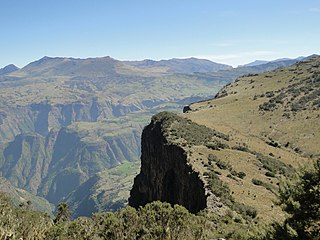
Dashen is one of the woredas in the Amhara Region of Ethiopia. Located at the northeastern point of the Semien Gondar Zone, dashen is bordered on the south by Jan Amora, on
Beyeda Previously known as Simien, is one of the woredas in the Amhara Region of Ethiopia. Located in the eastern most point of the Semien Gondar Zone, Beyeda is bordered on the south by the Wag Hemra Zone, on the west by Jan Amora, on the north by Tselemt, and on the east by the Tekezé River which separates it from the Tigray Region. The capital of Beyeda is Dil Yibza.
Jan Amora is one of the woredas in the Amhara Region of Ethiopia. Part of the Semien Gondar Zone, Jan Amora is bordered on the south by Misraq Belessa, on the southwest by Wegera, on the west by Debarq, on the north by Addi Arkay and Tselemt, on the east by Beyeda, and on the southeast by Wag Hemra Zone. The administrative center of Jan Amora is Mekane Berhan.
Debarq is one of the woredas in the Amhara Region of Ethiopia. It is named after its largest town, Debarq. Part of the Semien Gondar Zone, Debarq is bordered on the south by Dabat,
Dabat is a woreda in Amhara Region, Ethiopia. Part of the Semien Gondar Zone, Dabat is bordered on the south by Wegera, on the west by Tach Armachiho, on the northwest by Tegeda, and on the northeast by Debarq. Towns in Dabat include Dabat and Wekin.
Wegera or Wogera, is a woreda in Amhara Region, Ethiopia. Wegera is named for the former province Wegera, which was located roughly in the same location, and was later made part of the province of Semien. Part of the Semien Gondar Zone, Wegera is bordered on the south by Mirab Belessa, on the southwest by Gondar Zuria, on the west by Lay Armachiho, on the northwest by Tach Armachiho, on the north by Dabat, on the northeast by Jan Amora, and on the southeast by Misraq Belessa. Towns in Wegera include Amba Giyorgis and Gedegbe.
Gondar Zuria is a woreda in Amhara Region, Ethiopia. Part of the Semien Gondar Zone, Gondar Zuria is bordered on the south by the Debub Gondar Zone, on the southwest by Lake Tana, on the west by Dembiya, on the north by Lay Armachiho, on the northeast by Wegera, and on the southeast by Mirab Belessa. Towns in Gondar Zuria include Azazo, Degoma, Emfraz, Maksenit and Teda. The city and woreda of Gondar is surrounded by Gondar Zuria in the northern part of this woreda.
Chilga also Chelga, Ch'ilga is a woreda in Amhara Region, Ethiopia. It is named after its chief town Chilga, an important stopping point on the historic Gondar-Sudan trade route. Part of the Maekelawi Gondar Zone, Chilga is bordered on the south by Takusa, on the west by Metemma, on the north by Tach Armachiho, on the northeast by Lay Armachiho, and on the east by Dembiya. Other towns in Chilga include Seraba and Wohni.
Gidan is a woreda in the Amhara Region of Ethiopia. Part of the Semien Wollo Zone, Gidan is bordered on the south by Guba Lafto, on the southwest by Meket, on the west by Lasta, on the north by the Tigray Region, and on the east by Kobo. The administrative center of the woreda is Muja town, another small towns in Gidan include Debre Tsehay, Densa, Bekilo Mneqia, Iyella, Dildiy, Asikit, and Wonday.
Meket is a woreda in Amhara Region, Ethiopia. It is named after a former district located approximately in this area. Located on the western side of the Semien Wollo Zone, Meket is bordered on the south by Wadla and Dawunt, on the west by the Debub Gondar Zone, on the northwest by Bugna, on the north by Lasta, on the northeast by Gidan, and on the east by Guba Lafto. The administrative center of Meket is Filakit Gereger; other settlements include Debre Zebit and Weketa.
Wadla is a woreda in Amhara Region, Ethiopia. It is named for the former district which lay roughly in the same area. Part of the Semien Wollo Zone, Wadla is bordered on the southeast by Delanta, on the southwest by Dawunt, on the north by Meket, and on the northeast by Guba Lafto. The major town in Wadla is Gashena. Other towns include Kone and Arbit.
Dawuntna Delant was one of the 105 woredas in the Amhara Region of Ethiopia. Part of the Semien Wollo Zone, Dawuntna Delant was bordered on the south by the Checheho River which separated it from the Debub Wollo Zone, on the west by the Debub Gondar Zone, on the north by Wadla, and on the east by Guba Lafto. The deep valley of the Zhit'a river, which runs through Wadla and along part of the northern border, effectively isolates much of Dawuntna Delant from the rest of Semien Wollo. This woreda was named after two historical districts, Dawunt to the east and Delanta to the west. The major town in Dawuntna Delant was Wegeltena. This woreda was separated for Dawunt and Delanta woredas.
Guba Lafto is one of the woredas in the Amhara Region of Ethiopia. Part of the Semien Wollo Zone, Guba Lafto is bordered on the south by the Debub Wollo Zone, on the west by Delanta and Wadla, on the northwest by Meket, on the north by Gidan, on the northeast by the Logiya River which separates it from Kobo, and on the southeast by Habru. Weldiya is an enclave inside this woreda. Towns in this woreda include Hara.
Habru is a woreda in the Amhara Region of Ethiopia. Part of the Semien Wollo Zone, Habru is bordered on the south by the Mille River which separates it from the Debub Wollo Zone, on the west by Guba Lafto, on the north by the Alewuha River which separates it from Kobo, and on the east by the Afar Region. Towns in Habru include Mersa and Wurgessa.
Achefer was a woreda in Amhara Region, Ethiopia. It was named for the historic district of Achefer, which was first mentioned in the 16th century. Part of the Mirab Gojjam Zone, Achefer was bordered on the south by the Agew Awi Zone, on the west by the Semien Gondar Zone, on the north by Lake Tana, on the northeast by Bahir Dar Zuria, and on the southeast by Merawi; the Lesser Abay River defined the woreda's eastern boundary. The woreda included Dek Island. The administrative center was Yesmala; other towns in Achefer included Durbete, Liben, Kunzela, Chiba and Wandege. Acheref was divided for Debub Achefer and Semien Achefer woredas.
Bahir Dar Zuria is a woreda in Amhara Region, Ethiopia. Part of the Mirab Gojjam Zone, this woreda is bordered on the south by Yilmana Densa, on the southwest by Mecha, on the northwest by the Gilgel Abay River which separates it from Semien Achefer, on the north by Lake Tana, on the shores of Lake Tana situates the city and special zone of Bahir Dar, and on the east by the Abay River which separates it from the Debub Gondar Zone.
Nole Kaba is one of the woredas in the Oromia region of Ethiopia. Part of the West Welega Zone, Nole Kaba is bordered on the south by the Illubabor Zone, on the west by Kelem Welega Zone, on the northwest by Yubdo, and on the northeast by Haru. Towns in Nole Kaba include Bube. Sayo Nole woreda was separated from Nole Kaba.
Abichuna Gne'a is a woreda in Oromia Region, Ethiopia. This woreda is named in part for the Abichu Oromo. Part of the Kaba Shewa Zone, Abichu woreda is bordered on the south by Kembibit, on the west by Wuchalena Jido, and on the north and east by the Amhara Region. The major town in Abichu is Mendida.