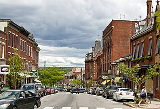
Belfast is a city in Waldo County, Maine, in the United States. As of the 2010 census, the city population was 6,668. Located at the mouth of the Passagassawakeag River estuary on Belfast Bay and Penobscot Bay. Belfast is the county seat of Waldo County. The seaport has a wealth of antique architecture in several historic districts, and remains popular with tourists.

Northport is a town on Penobscot Bay in Waldo County, Maine, United States. The population was 1,520 at the 2010 census.

The Maine Central Railroad Company was a former U. S. Class I railroad in central and southern Maine. It was chartered in 1856 and began operations in 1862. By 1884, Maine Central was the longest railroad in New England. Maine Central had expanded to 1,358 miles (2,185 km) when the United States Railroad Administration assumed control in 1917. The main line extended from South Portland, Maine, east to the Canada–United States border with New Brunswick, and a Mountain Division extended west from Portland to Vermont and north into Quebec. The main line was double track from South Portland to Royal Junction, where it split into a "lower road" through Brunswick and Augusta and a "back road" through Lewiston which converged at Waterville into single track to Bangor and points east. Branch lines served the industrial center of Rumford, a resort hotel on Moosehead Lake, and coastal communities from Bath to Eastport.

Penobscot Bay is an inlet of the Gulf of Maine and Atlantic Ocean in south central Maine. The bay originates from the mouth of Maine's Penobscot River, downriver from Belfast. Penobscot Bay has many working waterfronts including Rockland, Rockport, and Stonington, and Belfast upriver. Penobscot Bay is between Muscongus Bay and Blue Hill Bay, just west of Acadia National Park.
USS Belfast (PF-35), the only ship of the name, was a United States Navy Tacoma-class frigate in commission from 1943 to 1945. She then served in the Soviet Navy as EK-3.

The Belfast & Moosehead Lake Railroad was a standard-gauge shortline railroad that operated from 1871 to 2007 over a single-track grade from Belfast to Burnham Junction in Maine.

Penobscot Island Air is a small regional airline based at Knox County Regional Airport, Maine, United States (RKD) operating from a private terminal. The airline operates scheduled service to the islands in Maine's Penobscot Bay and offers private charter land and seaplane flights throughout the region.
Abiel Wood was a U.S. Representative from Massachusetts.
John Wilson was a U.S. Representative from Massachusetts.

The Passagassawaukeag River is a 16-mile-long (26 km) river in Waldo County, Maine in the United States. From the outlet of Lake Passagassawakeag in Brooks, it runs south and east to its estuary in Belfast, Maine. The river empties into Belfast Bay, an inlet of Penobscot Bay, where it passes under US Route 1.
U.S. Route 1 in the U.S. state of Maine is a major north–south state highway serving the eastern part of the state. It parallels the Atlantic Ocean from New Hampshire north through Portland, Brunswick, and Belfast to Calais, and then the St. Croix River and the rest of the Canada–US border via Houlton to Fort Kent. The portion along the ocean, known as the Coastal Route, provides a scenic alternate to Interstate 95 (I-95).

William George Crosby was an American politician and the 23rd Governor of Maine. A Whig, Crosby served two single-year terms as governor from 1853 to 1855.
Belfast Bay may refer to:

The Goose River is a river in Waldo County, Maine. From the outflow of Swan Lake in Swanville, the river runs 9.3 miles (15.0 km) south to the city of Belfast and its mouth at Belfast Bay, an arm of Penobscot Bay.
The Little River is a short river in Waldo County, Maine. From its source in Belmont, the river runs 8.0 miles (12.9 km) east to Belfast Bay, on the border between Belfast and Northport.

Moose Point State Park is a day-use public recreation area overlooking Penobscot Bay in Searsport, Maine, located off U.S. Route 1 near the Belfast town line. The state park features panoramic views, hiking trails, tidal pools, and picnicking facilities.

The Belfast Commercial Historic District encompasses two blocks of the central business district of Belfast, Maine. This area includes the best-preserved and most architecturally interesting commercial buildings of the city's mid-to-late 19th century development, when it was the leading port on Penobscot Bay. It extends along Main Street from the major intersection and Church Street north to Washington Street. It was listed on the National Register of Historic Places in 1980, and is entirely contained within the larger Belfast Historic District.

The James P. White House is a historic house at 1 Church Street in Belfast, Maine. Built in 1840, it is one of the city's most elaborate examples of Greek Revival architecture. It was listed on the National Register of Historic Places in 1973, and is included in Belfast's Church Street Historic District. In recent years it has served as a bed and breakfast inn but, as of 2015, is a private residence once again.


