Birch Bay is a census-designated place (CDP) in Whatcom County, Washington, United States. Birch Bay is a protected bay located between Semiahmoo Bay and Lummi Bay. It is also commonly referred to as the community near and around this body of water, but is actually not its own town. Birch Bay is approximately 100 miles (160 km) north of Seattle and 35 miles (56 km) south of Vancouver, BC, Canada. The population was 8,413 at the 2010 census, a 69.6% increase over the 2000 census.

The Costa Daurada is an area on the coast of Catalonia, Spain, between Cunit and Alcanar on the Mediterranean Sea. It is entirely included in the province of Tarragona.
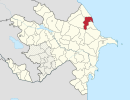
This is a list of the extreme points of Estonia: the points that are farther north, south, east or west than any other location.

The Musée d'Art et d'Histoire, is a museum located in the historical city of Saint-Denis, France, in the northern outskirts of Paris.

Gola is a village in the administrative district of Gmina Prusice, within Trzebnica County, Lower Silesian Voivodeship, in south-western Poland. Prior to 1945 it was in Germany.
Brochocin is a village in the administrative district of Gmina Zagrodno, within Złotoryja County, Lower Silesian Voivodeship, in south-western Poland. Prior to 1945 it was in Germany.
Gapa is a village in the administrative district of Gmina Kowalewo Pomorskie, within Golub-Dobrzyń County, Kuyavian-Pomeranian Voivodeship, in north-central Poland.
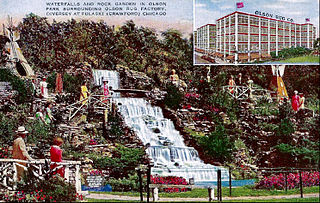
Olson Park and Waterfall was a heavily visited park and waterfall complex that was located in the Avondale community area of Chicago. It was built by Walter E. Olson, the owner of the Olson Rug Company, next to his factory and headquarters on the northwest corner of Diversey and Pulaski, and was a popular landmark for Chicago families. Built during the Great Depression the park was open to the public until it was closed in 1971 after Marshall Field bought the complex in 1965. The Chicago Tribune named Olson Park as the first of "Chicago's Seven Lost Wonders". The park's opening was famous for the fact that during its opening, the park was symbolically "deeded" back to Native Americans, observing the hundred year anniversary of the expulsion of Indians across the Mississippi River after the Blackhawk War. Today the site is occupied by a parking lot for the former Olson Rug factory and headquarters which is now occupied by the retailer Macy's.
Balin is a village in the administrative district of Gmina Poddębice, within Poddębice County, Łódź Voivodeship, in central Poland. It lies approximately 12 kilometres (7 mi) west of Poddębice and 48 km (30 mi) west of the regional capital Łódź.
Prospect is a small suburb of Launceston.
Szlasy-Umiemy is a village in the administrative district of Gmina Krasne, within Przasnysz County, Masovian Voivodeship, in east-central Poland.
Puc is a village in the administrative district of Gmina Kościerzyna, within Kościerzyna County, Pomeranian Voivodeship, in northern Poland. It lies approximately 7 kilometres (4 mi) east of Kościerzyna and 44 km (27 mi) south-west of the regional capital Gdańsk.
Osówek is a village in the administrative district of Gmina Osieczna, within Starogard County, Pomeranian Voivodeship, in northern Poland. It lies approximately 5 kilometres (3 mi) west of Osieczna, 34 km (21 mi) south-west of Starogard Gdański, and 73 km (45 mi) south-west of the regional capital Gdańsk.
Jerutki is a village in the administrative district of Gmina Świętajno, within Szczytno County, Warmian-Masurian Voivodeship, in northern Poland. It lies approximately 6 kilometres (4 mi) north-west of Świętajno, 11 km (7 mi) east of Szczytno, and 48 km (30 mi) south-east of the regional capital Olsztyn.
Trentham Racecourse is the main thoroughbred horse racecourse for the Wellington city area in New Zealand.
Holikachuk or Huligachagat is an abandoned village on the Innoko River in the U.S. state of Alaska.

Klisura is a village in the municipality of Višegrad, Bosnia and Herzegovina.
Galilee is an unincorporated community in Wayne County, in the U.S. state of Pennsylvania.

Salem Center is an unincorporated community in Salem Township, Steuben County, in the U.S. state of Indiana.