Shimamaki is a district located in Shiribeshi Subprefecture, Hokkaido, Japan.

Tokoro is a district located in Okhotsk Subprefecture, Hokkaido, Japan.

Gornja Stubica is a village and municipality in Krapina-Zagorje County, Croatia. According to the 2011 census, it has 5,284 inhabitants. An absolute majority of them are Croats.

Boreczek is a village in the administrative district of Gmina Borów, within Strzelin County, Lower Silesian Voivodeship, in south-western Poland.

Mrgavet, is a town in the Ararat Province of Armenia.

Szembruk is a village in the administrative district of Gmina Rogóźno, within Grudziądz County, Kuyavian-Pomeranian Voivodeship, in north-central Poland. It lies approximately 8 kilometres (5 mi) north-east of Rogóźno, 19 km (12 mi) north-east of Grudziądz, and 66 km (41 mi) north-east of Toruń.
Brzustowa is a village in the administrative district of Gmina Bobrowniki, within Lipno County, Kuyavian-Pomeranian Voivodeship, in north-central Poland. It lies approximately 6 kilometres (4 mi) east of Bobrowniki, 14 km (9 mi) south-west of Lipno, and 41 km (25 mi) south-east of Toruń.

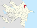
Bargyushad is a village in the Barda Rayon of Azerbaijan.

The National Archives of Hungary were created in 1756. They were first located in Pressburg. In 1784, they were transferred to Buda.

Mincivan, in Armenian Mijnavan is a town in the Kashatagh Region of the de facto independent Republic of Artsakh. However, it is a de jure part of the Republic of Azerbaijan, with the status of an administrative division of the surrounding Zangilan Rayon. Its population as of 2010 is 324.

The Saleina Glacier is a 6 km (3.7 mi) long glacier (2002) situated on the north-eastern edge of the Mont Blanc Massif in the canton of Valais in Switzerland. It flows in a roughly north-easterly direction from the Aiguille d'Argentière, down towards the Val Ferret. The Saleina Hut sits above its right bank at an altitude of 2,691 meters above sea level.

Tai Tong Road is an at-grade MTR Light Rail stop located at the junction of Castle Peak Road and Tai Tong Road in Yuen Long District. It began service on 18 September 1988 and belongs to Zone 5. This stop used to be known as "大棠道" in Chinese but it was renamed to "大棠路" on 13 June 2010; its English name remains unchanged.
Różnowo is a village in the administrative district of Gmina Miłakowo, within Ostróda County, Warmian-Masurian Voivodeship, in northern Poland. It lies approximately 4 kilometres (2 mi) north-west of Miłakowo, 37 km (23 mi) north of Ostróda, and 41 km (25 mi) north-west of the regional capital Olsztyn.

Hoppaw is an unincorporated community in Del Norte County, California. It is located on Hoppaw Creek 3 miles (4.8 km) east-southeast of the mouth of the Klamath River, at an elevation of 36 feet. It appears in the Requa U.S. Geological Survey Map.
Moonstone is an unincorporated community in Humboldt County, California. It is located 2.5 miles (4.0 km) southeast of Trinidad, at an elevation of 121 feet. For census purposes, it is aggregated in Westhaven-Moonstone, California. The area is sited adjacent to Pacific Ocean beach and the mouth of the Little River with views of the rugged coastline.
Sidi Ali Ben Aoun is a town and commune in the Sidi Bou Zid Governorate, Tunisia. As of 2004 it had a population of 7,403.
Chhapi is a village in Gujarat, India.

Sweileh (صويلح) is district number sixteen in Amman out of twenty-seven. It lies in Jordan to the north of Amman with a population of over 151,016.
El Marsa is a town and commune in Skikda Province in north-eastern Algeria.
Alazon is an extinct town in Elko County, in the U.S. state of Nevada. The GNIS classifies it as a populated place.