Dříteč is a village in the Pardubice Region of the Czech Republic. It has 348 (30.5.2008) inhabitants.

Makowice is a village in the administrative district of Gmina Świdnica, within Świdnica County, Lower Silesian Voivodeship, in south-western Poland. Prior to 1945 it was in Germany.

Karnut is a village in the Shirak Province of Armenia.
Putnowice-Kolonia is a village in the administrative district of Gmina Wojsławice, within Chełm County, Lublin Voivodeship, in eastern Poland.

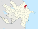
Pirəqanım is a village in the Ismailli Rayon of Azerbaijan. The village forms part of the municipality of Müdrəsə. According to Azerbaijan's State Statistics Committee, only two people lived in the village as of 2014.

Kənzə is a village in the Ismailli Rayon of Azerbaijan. The village forms part of the municipality of Qoşakənd. According to Azerbaijan's State Statistics Committee, only three people lived in the village as of 2014.
Kirk is a village in the Ismailli Rayon of Azerbaijan. The village forms part of the municipality of Kəlbənd.
Borek Lipiński is a village in the administrative district of Gmina Warta, within Sieradz County, Łódź Voivodeship, in central Poland. It lies approximately 13 kilometres (8 mi) east of Warta, 13 km (8 mi) north of Sieradz, and 47 km (29 mi) west of the regional capital Łódź.
Adamów is a village in the administrative district of Gmina Opatów, within Opatów County, Świętokrzyskie Voivodeship, in south-central Poland. It lies approximately 3 kilometres (2 mi) east of Opatów and 60 km (37 mi) east of the regional capital Kielce.
Zasiadały is a village in the administrative district of Gmina Miastków Kościelny, within Garwolin County, Masovian Voivodeship, in east-central Poland.
Dębie is a village in the administrative district of Gmina Grójec, within Grójec County, Masovian Voivodeship, in east-central Poland.
Trzylatków Mały is a village in the administrative district of Gmina Błędów, within Grójec County, Masovian Voivodeship, in east-central Poland. It lies approximately 14 kilometres (9 mi) south-west of Grójec and 50 km (31 mi) south-west of Warsaw.
Jelonki is a village in the administrative district of Gmina Ostrów Mazowiecka, within Ostrów Mazowiecka County, Masovian Voivodeship, in east-central Poland. It lies approximately 12 kilometres (7 mi) north-west of Ostrów Mazowiecka and 93 km (58 mi) north-east of Warsaw.
Cisze is a village in the administrative district of Gmina Chodzież, within Chodzież County, Greater Poland Voivodeship, in west-central Poland. It lies approximately 7 kilometres (4 mi) west of Chodzież and 67 km (42 mi) north of the regional capital Poznań.
Franciszkowo is a village in the administrative district of Gmina Poniec, within Gostyń County, Greater Poland Voivodeship, in west-central Poland.
Zawada is a village in the administrative district of Gmina Gubin, within Krosno Odrzańskie County, Lubusz Voivodeship, in western Poland, close to the German border. It lies approximately 7 kilometres (4 mi) east of Gubin, 24 km (15 mi) south-west of Krosno Odrzańskie, and 48 km (30 mi) west of Zielona Góra.
Knybawa is a village in the administrative district of Gmina Tczew, within Tczew County, Pomeranian Voivodeship, in northern Poland. It lies approximately 8 kilometres (5 mi) south-east of Tczew and 37 km (23 mi) south of the regional capital Gdańsk.
Dworzec is a village in the administrative district of Gmina Biskupiec, within Olsztyn County, Warmian-Masurian Voivodeship, in northern Poland.
Szymonówko is a village in the administrative district of Gmina Małdyty, within Ostróda County, Warmian-Masurian Voivodeship, in northern Poland. It lies approximately 11 kilometres (7 mi) south-east of Małdyty, 19 km (12 mi) north-west of Ostróda, and 46 km (29 mi) west of the regional capital Olsztyn.
Pałowo is a village in the administrative district of Gmina Postomino, within Sławno County, West Pomeranian Voivodeship, in north-western Poland. It lies approximately 9 kilometres (6 mi) south-east of Postomino, 12 km (7 mi) north-east of Sławno, and 185 km (115 mi) north-east of the regional capital Szczecin.