Sarvan, Shabran

Last updated

Coordinates: 41°16′58″N49°01′16″E / 41.28278°N 49.02111°E / 41.28278; 49.02111

Geographic coordinate system Coordinate system

A geographic coordinate system is a coordinate system that enables every location on Earth to be specified by a set of numbers, letters or symbols. The coordinates are often chosen such that one of the numbers represents a vertical position and two or three of the numbers represent a horizontal position; alternatively, a geographic position may be expressed in a combined three-dimensional Cartesian vector. A common choice of coordinates is latitude, longitude and elevation. To specify a location on a plane requires a map projection.

Sarvan
Azerbaijan adm location map.svg
Red pog.svg
Sarvan
Coordinates: 41°16′58″N49°01′16″E / 41.28278°N 49.02111°E / 41.28278; 49.02111
CountryFlag of Azerbaijan.svg  Azerbaijan
Rayon Davachi
Municipality Xəlilli
Time zone AZT (UTC+4)
  Summer (DST) AZT (UTC+5)

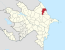
Sarvan (also, Sarven”) is a village in the Davachi Rayon of Azerbaijan. The village forms part of the municipality of Xəlilli. [1]

Azerbaijan Republic in Western Asia and Eastern Europe

Azerbaijan, officially the Republic of Azerbaijan, is a landlocked country in the South Caucasus region of Eurasia at the crossroads of Eastern Europe and Western Asia. It is bounded by the Caspian Sea to the east, Russia to the north, Georgia to the northwest, Armenia to the west and Iran to the south. The exclave of Nakhchivan is bound by Armenia to the north and east, Iran to the south and west, and has an 11 km long border with Turkey in the northwest.

Xəlilli, Davachi Municipality in Davachi, Azerbaijan

Xəlilli is a village and municipality in the Davachi Rayon of Azerbaijan. It has a population of 433. The municipality consists of the villages of Xələlli, Liman, and Sarvan.

Related Research Articles

Siyəzən Municipality in Siazan, Azerbaijan

Siyəzən is a city and municipality in, and the capital of, the Siazan Rayon of Azerbaijan. It has a population of 24,900.

Zuygaghbyur Place in Shirak, Armenia

Zuygaghbyur is a village in the Shirak Province of Armenia.

Rük Place in Quba, Azerbaijan

Rük is a village in the Quba Rayon of Azerbaijan. The village forms part of the municipality of Söhüb.

Agasibeyli Place in Siazan, Azerbaijan

Agasibeyli is a village in the Siazan Rayon of Azerbaijan.

Müşkülqazma Place in Siazan, Azerbaijan

Müşkülqazma is a village in the Siazan Rayon of Azerbaijan. The village forms part of the municipality of Sədan.

Kolanı, Siazan Place in Siazan, Azerbaijan

Kolanı is a village in the Siazan Rayon of Azerbaijan. The village forms part of the municipality of Yenikənd.

Mürsəlliqışlaq Place in Khachmaz, Azerbaijan

Mürsəlliqışlaq is a village in the Khachmaz Rayon of Azerbaijan. The village forms part of the municipality of Qobuqıraq.

Kiçik Baraxum Place in Khachmaz, Azerbaijan

Kiçik Baraxum is a village in the Khachmaz Rayon of Azerbaijan. The village forms part of the municipality of Dədəli.

Zeyxuroba Place in Khachmaz, Azerbaijan

Zeyxuroba is a village in the Khachmaz Rayon of Azerbaijan. The village forms part of the municipality of Yalama.

Sarvan, Salyan Municipality in Salyan, Azerbaijan

Sarvan is a village and municipality in the Salyan Rayon of Azerbaijan. It has a population of 2,508.

Şərifoba Place in Khachmaz, Azerbaijan

Şərifoba is a village in the Khachmaz Rayon of Azerbaijan. The village forms part of the municipality of Uzunoba.

Berlanga, Badajoz Place in Extremadura, Spain

Berlanga is a Spanish municipality in the province of Badajoz, Extremadura. It has a population of 2,546 (2007) and an area of 127.8 km².

Ağbaş is a village and municipality in the Davachi Rayon of Azerbaijan. It has a population of 1,751.

Józefowo is a former village in the administrative district of Gmina Wronki, within Szamotuły County, Greater Poland Voivodeship, in west-central Poland.

Łodzierz Village in Pomeranian, Poland

Łodzierz is a village in Gmina Miastko, Bytów County, Pomeranian Voivodeship, in northern Poland. It lies approximately 38 kilometres (24 mi) south-west of Bytów and 116 km (72 mi) south-west of Gdańsk.

Ostrów, Myszków County Village in Silesian, Poland

Ostrów is a village in the administrative district of Gmina Żarki, within Myszków County, Silesian Voivodeship, in southern Poland. It lies approximately 7 kilometres (4 mi) west of Żarki, 8 km (5 mi) north of Myszków, and 49 km (30 mi) north-east of the regional capital Katowice.

Staňkovice is a village and municipality in Kutná Hora District in the Central Bohemian Region of the Czech Republic.

Happy Valley No. 10 is a rural municipality in the Canadian province of Saskatchewan. It is located in southeastern Saskatchewan and is within SARM Division No. 2 and Census Division No. 2. Its population was 174 as of the 2006 Census. The southern boundary of the RM is the United States border with Daniels County and Sheridan County, both in Montana.

Belanovce (Leskovac) Village in Jablanica District, Serbia

Belanovce is a village in the municipality of Leskovac, Serbia. According to the 2002 census, the village has a population of 600 people.

Hamri (Algeria) Commune and town in Relizane Province, Algeria

Hamri is a town and commune in Relizane Province, Algeria.

References

  1. "Belediyye Informasiya Sistemi" (in Azerbaijani). Archived from the original on September 24, 2008.