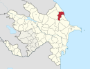
Qızılqazma, Shabran

Last updated

Coordinates: 40°57′50″N48°50′00″E / 40.96389°N 48.83333°E / 40.96389; 48.83333

Geographic coordinate system Coordinate system

A geographic coordinate system is a coordinate system that enables every location on Earth to be specified by a set of numbers, letters or symbols. The coordinates are often chosen such that one of the numbers represents a vertical position and two or three of the numbers represent a horizontal position; alternatively, a geographic position may be expressed in a combined three-dimensional Cartesian vector. A common choice of coordinates is latitude, longitude and elevation. To specify a location on a plane requires a map projection.

Qızılqazma
Azerbaijan adm location map.svg
Red pog.svg
Qızılqazma
Coordinates: 40°57′50″N48°50′00″E / 40.96389°N 48.83333°E / 40.96389; 48.83333
CountryFlag of Azerbaijan.svg  Azerbaijan
Rayon Shabran
Municipality Çuxurazəmi
Time zone AZT (UTC+4)
  Summer (DST) AZT (UTC+5)

Qızılqazma (also, Kyzylkazma) is a village in the Shabran Rayon of Azerbaijan. The village forms part of the municipality of Çuxurazəmi. [1]

Azerbaijan Country in the South Caucasus

Azerbaijan, officially the Republic of Azerbaijan, is a country in the South Caucasus region of Eurasia at the crossroads of Eastern Europe and Western Asia. It is bounded by the Caspian Sea to the east, Russia to the north, Georgia to the northwest, Armenia to the west and Iran to the south. The exclave of Nakhchivan is bounded by Armenia to the north and east, Iran to the south and west, and has an 11 km long border with Turkey in the northwest.

Çuxurazəmi Municipality in Davachi, Azerbaijan

Çuxurazəmi is a village and municipality in the Davachi Rayon of Azerbaijan. It has a population of 287. The municipality consists of the villages of Çuxurəzəmi, Qızılqazma, Qəriblik, Dəhnə, Covrurah, and Zöhrabkənd.

Related Research Articles

Shabran District District in Azerbaijan

Shabran is a district of Azerbaijan. Şabran city is its administrative center.

Sumay-ye Beradust District district in Iran

Sumay-ye Beradust District is a district (bakhsh) in Urmia County, West Azerbaijan Province, Iran. It is west of Lake Urmia, between the city of Urmia and the border with Turkey. Its administrative seat is the town of Serow. At the 2006 census, its population was 39,802, in 6,760 families. The District has one city: Serow. The District has three rural districts (dehestan): Beradust Rural District, Sumay-ye Jonubi Rural District, and Sumay-ye Shomali Rural District.

Şabran City & Municipality in Azerbaijan

Şabran is a city in and the capital of the Şabran Rayon of Azerbaijan.

Güləh Place in Davachi District, Azerbaijan

Güləh is a village in the Shabran District of Azerbaijan. The village forms part of the municipality of Çaraq.

Aydinlar, Shabran Place in Davachi, Azerbaijan

Aydinlar is a village in the Shabran District of Azerbaijan.

Gömür, Shabran Place in Davachi, Azerbaijan

Gömür is a village in the Davachi Rayon of Azerbaijan.

Yeləkəsən Place in Şabran, Azerbaijan

Yeləkəsən is a village in the Shabran District of Azerbaijan. The village forms part of the municipality of Xəlfələr.

Allahyarlı, Shabran Place in Davachi, Azerbaijan

Allahyarlı is a village in the Davachi Rayon of Azerbaijan.

Sarvan, Shabran Place in Davachi, Azerbaijan

Sarvan is a village in the Davachi Rayon of Azerbaijan. The village forms part of the municipality of Xəlilli.

Namazgah, Azerbaijan Place in Ismailli, Azerbaijan

Namazgah is a village in the Ismailli Rayon of Azerbaijan. The village forms part of the municipality of Ərəkit.

İkinci Yalama Place in Khachmaz, Azerbaijan

İkinci Yalama is a village in the Khachmaz Rayon of Azerbaijan.

Qızılqazma, Khizi Place in Khizi, Azerbaijan

Qızılqazma is a village in the Khizi Rayon of Azerbaijan. The village forms part of the municipality of Altıağac.

Shykhly Place in Davachi, Azerbaijan

Shykhly is a village in the Shabran District of Azerbaijan.

Zarat, Shabran Place in Davachi, Azerbaijan

Zarat is a village in the Davachi Rayon of Azerbaijan.

Səfalı Place in Shamakhi, Azerbaijan

Səfalı is a village in the Shamakhi Rayon of Azerbaijan. The village forms part of the municipality of Dəmirçi.

Kamocka Wola Village in Łódź, Poland

Kamocka Wola is a village in the administrative district of Gmina Aleksandrów, within Piotrków County, Łódź Voivodeship, in central Poland. It lies approximately 3 kilometres (2 mi) north-west of Aleksandrów, 24 km (15 mi) south-east of Piotrków Trybunalski, and 65 km (40 mi) south-east of the regional capital Łódź.

Kankandi is a village and rural commune in Niger.

Shirvanshahs bath houses

The palatial bath houses of the Shirvanshahs are dated back to the 15th century and are a part of the Shirvanshahs’ Palace Complex. It is in the eastern part of a lower yard.

Shabran – was a historical town and district which existed from the 5th to the 18th centuries. It was in what is now the eastern part of the Azerbaijani Republic, within the borders of Greater Caucasus pass, located between Baku and Quba. It was completely destroyed in 1723.

References

  1. "Belediyye Informasiya Sistemi" (in Azerbaijani). Archived from the original on September 24, 2008.