The Ter is a river in Catalonia, Spain, that rises in Ulldeter at an approximate elevation of 2,400 metres (7,900 ft), at the foot of a glacial cirque delimited by the nearby peaks of el Bastiments, el Gra de Fajol, or el Pic de la Dona. It runs through the comarques of Ripollès, Osona, Selva, Gironès, and Baix Empordà, discharging into the Mediterranean Sea at l'Estartit.

Saha District is a gu in western Busan, South Korea. It has an area of 40.89 km², and a population of about 375,000. About a third of the area is forest land. Saha-gu became a gu of Busan in 1983. It is home to the Seunghak Campus of Dong-A University.
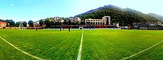
Gandzasar Stadium, also known as Kapan City Stadium, is a multi-purpose stadium in Kapan, the capital of Syunik Province, Armenia. It is currently used mostly for football matches and is the home ground of Gandzasar. With a capacity of 3,500, Gandzasar Stadium is located at the centre of the town of Kapan, on the left bank of Voghji River, between Aram Manukian and Hovhannes Tumanyan streets. Kapan town hall is located at the eastern edge of the stadium

Drzonowo is a village in the administrative district of Gmina Lisewo, within Chełmno County, Kuyavian-Pomeranian Voivodeship, in north-central Poland. It lies approximately 5 kilometres (3 mi) south of Lisewo, 22 km (14 mi) south-east of Chełmno, and 26 km (16 mi) north of Toruń.
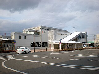
Jinryō Station is a railway station in Kasugai, Aichi Prefecture, Japan.
Gabrylewszczyzna is a village in the administrative district of Gmina Janów, within Sokółka County, Podlaskie Voivodeship, in north-eastern Poland.

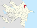
Xallanlı is a village in the Kalbajar Rayon of Azerbaijan.
Qarğalıq is a village in the Khachmaz Rayon of Azerbaijan. The village forms part of the municipality of İlxıçı.
Zwódne is a village in the administrative district of Gmina Zamość, within Zamość County, Lublin Voivodeship, in eastern Poland. It lies approximately 5 kilometres (3 mi) south of Zamość and 80 km (50 mi) south-east of the regional capital Lublin.
Wielobłota is a village in the administrative district of Gmina Zabór, within Zielona Góra County, Lubusz Voivodeship, in western Poland. It lies approximately 4 kilometres (2 mi) north-west of Zabór and 13 km (8 mi) east of Zielona Góra.

Harleigh is a census-designated place (CDP) in Hazle Township, Luzerne County, Pennsylvania, United States, north of the city of Hazleton. The CDP population was 1,104 at the 2010 census.

Öresundsparken is a park in Malmö, Sweden. The park was built in the 1920s to fill the area beside the railway line. It was opened in 1924 and consists mainly of three ponds.

Ouled Mansour is a town and commune in M'Sila Province, Algeria. According to the 1998 census it has a population of 4,896.

Miokovci is a village in the municipality of Čačak, Serbia. According to the 2011 census, the village has a population of 969 people.
Männiku is a village in Märjamaa Parish, Rapla County in western Estonia.

Krušev Do is a village in the municipality of Srebrenica, Bosnia and Herzegovina.
The Veveno River is a river in eastern South Sudan. It is a tributary of the Lotilla River, which it joins southwest of Pibor.
Kalak is a village in Miandorud-e Kuchak Rural District, in the Central District of Sari County, Mazandaran Province, Iran. At the 2006 census, its population was 58, in 18 families.

Fitz-Greene Halleck is an outdoor bronze sculpture of Fitz-Greene Halleck by James Wilson Alexander MacDonald, located in Central Park in Manhattan, New York. Commissioned by William Cullen Bryant and James Grant Wilson following Halleck's death in 1867, the statue was cast in 1876 and installed in 1877, becoming the first in Central Park depicting an American. An estimated 10,000 people attended its dedication on May 15, 1877.

Belenkeşlik Castle is a medieval castle in Mersin Province, Turkey. At 36°58′20″N34°33′12″E, it is situated to the north of Soğucak belde (town) of Mersin. Its distance to Mersin centreum is about 20 kilometres (12 mi).