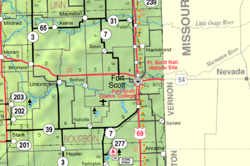
Berlin, Kansas

Last updated

Berlin, Kansas
Map of Bourbon Co, Ks, USA.png
Coordinates: 37°55′17″N94°53′46″W / 37.92139°N 94.89611°W / 37.92139; -94.89611 [1]
Country United States
State Kansas
County Bourbon
Named for Berlin, Georgia
Elevation
[1]
909 ft (277 m)
Time zone UTC-6 (CST)
  Summer (DST) UTC-5 (CDT)
Area code 620
FIPS code 20-06240
GNIS ID 474538 [1]

Berlin is an unincorporated community in Bourbon County, Kansas, United States. [1]

Contents

History

A post office was opened in Berlin in 1879, and remained in operation until it was discontinued in 1903. [2] The community has most likely been named in the honor of Berlin, Georgia.

Related Research Articles

<span class="mw-page-title-main">Linn County, Kansas</span> County in Kansas, United States

Linn County is a county in the U.S. state of Kansas, located in along the eastern edge of Kansas, and is part of the Kansas City metropolitan area. Its county seat is Mound City, and its most populous city is Pleasanton. As of the 2020 census, the county population was 9,591. The county was named for Lewis Linn, a U.S. Senator from Missouri.

<span class="mw-page-title-main">Bourbon County, Kansas</span> County in Kansas, United States

Bourbon County is a county located in Southeast Kansas. Its county seat and most populous city is Fort Scott. As of the 2020 census, the county population was 14,360. The county was named after Bourbon County, Kentucky, the former home of many early settlers.

<span class="mw-page-title-main">Mapleton, Kansas</span> City in Kansas, United States

Mapleton is a city in Bourbon County, Kansas, United States. As of the 2020 census, the population of the city was 96.

<span class="mw-page-title-main">Xenia, Kansas</span> Unincorporated community in Kansas, United States

Xenia is a unincorporated in Franklin Township, Bourbon County, Kansas, United States.

<span class="mw-page-title-main">St. Joseph, Kansas</span> Unincorporated community in Cloud County, Kansas

St. Joseph is an unincorporated community in Cloud County, Kansas, United States.

<span class="mw-page-title-main">Marmaton Township, Bourbon County, Kansas</span> Township in Kansas, United States

Marmaton Township is a township in Bourbon County, Kansas, USA. As of the 2000 census, its population was 815.

<span class="mw-page-title-main">Shirley Township, Cloud County, Kansas</span> Township in Kansas, United States

Shirley Township is a township in Cloud County, Kansas, USA. As of the 2000 census, its population was 178.

<span class="mw-page-title-main">National Register of Historic Places listings in Bourbon County, Kansas</span>

This is a list of the National Register of Historic Places listings in Bourbon County, Kansas.

<span class="mw-page-title-main">Garland, Kansas</span> Unincorporated community and Census designated place in Kansas, United States

Garland is an unincorporated community in Bourbon County, Kansas, United States. As of the 2020 census, the population of the community and nearby areas was 31. It is located along the Missouri state line 8.5 miles (13.7 km) southeast of Fort Scott.

<span class="mw-page-title-main">Hiattville, Kansas</span> Unincorporated community in Kansas, United States

Hiattville is an unincorporated community in Bourbon County, Kansas, United States.

<span class="mw-page-title-main">Marmaton, Kansas</span> Unincorporated community in Kansas, United States

Marmaton is an unincorporated community in Bourbon County, Kansas, United States. The community is located three miles east of Redfield, and two miles south of U.S. Route 54, at the intersection of 155th Street and Limestone Road.

<span class="mw-page-title-main">Devon, Kansas</span> Unincorporated community and Census designated place in Kansas, United States

Devon is an unincorporated community in Bourbon County, Kansas, United States. As of the 2020 census, the population of the community and nearby areas was 71.

<span class="mw-page-title-main">Pawnee Station, Kansas</span> Unincorporated community in Kansas, United States

Pawnee Station is an unincorporated community in Bourbon County, Kansas, United States.

<span class="mw-page-title-main">Hammond, Kansas</span> Unincorporated community in Kansas, United States

Hammond is an unincorporated community in Bourbon County, Kansas, United States.

<span class="mw-page-title-main">Barnesville, Kansas</span> Unincorporated community in Kansas, United States

Barnesville is an unincorporated community in Bourbon County, Kansas, United States.

<span class="mw-page-title-main">Porterville, Kansas</span> Unincorporated community in Kansas, United States

Porterville is an unincorporated community in Bourbon County, Kansas, United States.

<span class="mw-page-title-main">Godfrey, Kansas</span> Unincorporated community in Kansas, United States

Godfrey is an unincorporated community in Bourbon County, Kansas, United States.

<span class="mw-page-title-main">Harding, Kansas</span> Unincorporated community in Kansas, United States

Harding is an unincorporated community in Bourbon County, Kansas, United States.

<span class="mw-page-title-main">Bourbon virus</span> Species of virus

Bourbon virus is an RNA virus in the genus Thogotovirus of the family Orthomyxoviridae, which is similar to Dhori virus and Batken virus. It was first identified in 2014 in a man from Bourbon County, Kansas, United States, who died after being bitten by ticks. The case is the eighth report of human disease associated with a thogotovirus globally, and the first in the Western hemisphere. As of May 2015, a case was discovered in Stillwater, Oklahoma and relatively little is known about the virus. No specific treatment or vaccine is available. The virus is suspected to be transmitted by ticks or insects, and avoidance of bites is recommended to reduce risk of infection. In June 2017 a 58-year-old female Missouri State Park employee died from an infection of the Bourbon virus after it had been misdiagnosed for a significant period of time.

Bourbon is an unincorporated community in northern Boone County, in the U.S. state of Missouri. The community was located on Benson Road just east of U.S. Route 63 and about one mile west of Sturgeon.

References

  1. 1 2 3 4 U.S. Geological Survey Geographic Names Information System: Berlin, Kansas
  2. "Kansas Post Offices, 1828-1961". Kansas Historical Society. Retrieved August 2, 2014.

Further reading