
Neosho County is a county located in Southeast Kansas. Its county seat is Erie. As of the 2020 census, the county population was 15,904. The county was named for the Neosho River, which passes through the county.
Crawford County is a county located in Southeast Kansas. Its county seat is Girard, and its most populous city is Pittsburg. As of the 2020 census, the county population was 38,972. The county was named in honor of Samuel Crawford, the 3rd governor of Kansas. Pittsburg State University is located in Crawford County.

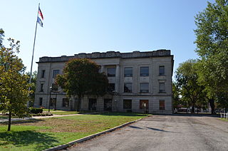
Bourbon County is a county located in Southeast Kansas. Its county seat and most populous city is Fort Scott. As of the 2020 census, the county population was 14,360. The county was named after Bourbon County, Kentucky, the former home of many early settlers.

Allen County is a county located in the southeast portion of the U.S. state of Kansas. Its county seat and most populous city is Iola. As of the 2020 census, the population was 12,526. The county was named for William Allen, a U.S. Senator from Ohio and prominent supporter of westward expansion.

Kansas' 2nd congressional district is a congressional district in the U.S. state of Kansas that covers most of the eastern part of the state, except for the core of the Kansas City Metropolitan Area. The district encompasses less than a quarter of the state. The state capital of Topeka, the cities of Emporia, Junction City and Leavenworth and most of Kansas City are located within this district. The district is currently represented by Republican Jake LaTurner.

Xenia is an unincorporated community in Franklin Township, Bourbon County, Kansas, United States.

St. Joseph is an unincorporated community in Cloud County, Kansas, United States.

Pawnee Township is a township in Bourbon County, Kansas, United States. As of the 2000 census, its population was 308.

LeLoup is an unincorporated community in Franklin County, Kansas, United States. It is located a mile and half north of Interstate 35 on Tennessee Road, 11 miles northeast of Ottawa, 7 miles southwest of Wellsville.
Garland is an unincorporated community in Bourbon County, Kansas, United States. As of the 2020 census, the population of the community and nearby areas was 31. It is located along the Missouri state line 8.5 miles (13.7 km) southeast of Fort Scott.
Marmaton is an unincorporated community in Bourbon County, Kansas, United States. The community is located three miles east of Redfield, and two miles south of U.S. Route 54, at the intersection of 155th Street and Limestone Road.
Devon is an unincorporated community in Bourbon County, Kansas, United States. As of the 2020 census, the population of the community and nearby areas was 71.
Pawnee Station is an unincorporated community in Bourbon County, Kansas, United States.
Hammond is an unincorporated community in Bourbon County, Kansas, United States.
Berlin is an unincorporated community in Bourbon County, Kansas, United States.
Barnesville is an unincorporated community in Bourbon County, Kansas, United States.
Porterville is an unincorporated community in Bourbon County, Kansas, United States.
Godfrey is an unincorporated community in Bourbon County, Kansas, United States.
Harding is an unincorporated community in Bourbon County, Kansas, United States.

