Hammond, Kansas

Last updated

Hammond, Kansas
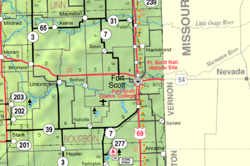
Map of Bourbon Co, Ks, USA.png
Coordinates: 37°56′08″N94°41′43″W / 37.93556°N 94.69528°W / 37.93556; -94.69528 [1]
Country United States
State Kansas
County Bourbon
Elevation
[1]
869 ft (265 m)
Time zone UTC-6 (CST)
  Summer (DST) UTC-5 (CDT)
Area code 620
FIPS code 20-29750 [1]
GNIS ID 474572 [1]

Hammond is an unincorporated community in Bourbon County, Kansas, United States. [1]

Contents

History

A post office was established at Hammond in 1877, and remained in operation until it was discontinued in 1968. [2] The community was named for a family of early settlers. [3]

Education

The community is served by Fort Scott USD 234 public school district.

Related Research Articles

<span class="mw-page-title-main">Bourbon County, Kansas</span> County in Kansas, United States

Bourbon County is a county located in Southeast Kansas. Its county seat and most populous city is Fort Scott. As of the 2020 census, the county population was 14,360. The county was named after Bourbon County, Kentucky, the former home of many early settlers.

<span class="mw-page-title-main">Bronson, Kansas</span> City in Kansas, United States of America

Bronson is a city in Bourbon County, Kansas, United States. As of the 2020 census, the population of the city was 304.

<span class="mw-page-title-main">Fort Scott, Kansas</span> City and County seat in Kansas, United States

Fort Scott is a city in and the county seat of Bourbon County, Kansas, United States. As of the 2020 census, the population of the city was 7,552. It is named for Gen. Winfield Scott. The city is located 88 miles (142 km) south of Kansas City on the Marmaton River. It is the home of the Fort Scott National Historic Site and the Fort Scott National Cemetery.

<span class="mw-page-title-main">Fulton, Kansas</span> City in Kansas, United States

Fulton is a city in Bourbon County, Kansas, United States. As of the 2020 census, the population of the city was 165.

<span class="mw-page-title-main">Mapleton, Kansas</span> City in Kansas, United States

Mapleton is a city in Bourbon County, Kansas, United States. As of the 2020 census, the population of the city was 96.

<span class="mw-page-title-main">Fort Scott National Historic Site</span> National Historic Site of the United States

Fort Scott National Historic Site is a historical area under the control of the United States National Park Service in Bourbon County, Kansas, United States. Named after General Winfield Scott, who achieved renown during the Mexican–American War, during the middle of the 19th century the fort served as a military base for US Army action in what was the edge of settlement in 1850. For the next quarter century, it was used as a supply base and to provide security in turbulent areas during the opening of the West to settlement, a period which included Bleeding Kansas and the American Civil War.

<span class="mw-page-title-main">Little Osage River</span> River in Missouri, United States

The Little Osage River is an 88-mile-long (142 km) tributary of the Osage River in eastern Kansas and western Missouri in the United States. Via the Osage and Missouri rivers, it is part of the watershed of the Mississippi River.

<span class="mw-page-title-main">Fort Scott National Cemetery</span> Historic veterans cemetery in Bourbon County, Kansas

Fort Scott National Cemetery is a United States National Cemetery located in Fort Scott, in Bourbon County, Kansas. Administered by the United States Department of Veterans Affairs, it encompasses 21.8 acres (8.8 ha), and as of 2021, had more than 8,000 interments. It is one of three national cemeteries in Kansas.

<span class="mw-page-title-main">Xenia, Kansas</span> Unincorporated community in Kansas, United States

Xenia is an unincorporated community in Franklin Township, Bourbon County, Kansas, United States.

<span class="mw-page-title-main">Garland, Kansas</span> Unincorporated community in Kansas, United States

Garland is an unincorporated community in Bourbon County, Kansas, United States. As of the 2020 census, the population of the community and nearby areas was 31. It is located along the Missouri state line 8.5 miles (13.7 km) southeast of Fort Scott.

<span class="mw-page-title-main">Marmaton, Kansas</span> Unincorporated community in Kansas, United States

Marmaton is an unincorporated community in Bourbon County, Kansas, United States. The community is located three miles east of Redfield, and two miles south of U.S. Route 54, at the intersection of 155th Street and Limestone Road.

<span class="mw-page-title-main">Devon, Kansas</span> Unincorporated community in Kansas, United States

Devon is an unincorporated community in Bourbon County, Kansas, United States. As of the 2020 census, the population of the community and nearby areas was 71.

<span class="mw-page-title-main">Pawnee Station, Kansas</span> Unincorporated community in Kansas, United States

Pawnee Station is an unincorporated community in Bourbon County, Kansas, United States.

<span class="mw-page-title-main">Berlin, Kansas</span> Unincorporated community in Kansas, United States

Berlin is an unincorporated community in Bourbon County, Kansas, United States.

<span class="mw-page-title-main">Barnesville, Kansas</span> Unincorporated community in Kansas, United States

Barnesville is an unincorporated community in Bourbon County, Kansas, United States.

<span class="mw-page-title-main">Porterville, Kansas</span> Unincorporated community in Kansas, United States

Porterville is an unincorporated community in Bourbon County, Kansas, United States.

<span class="mw-page-title-main">Godfrey, Kansas</span> Unincorporated community in Kansas, United States

Godfrey is an unincorporated community in Bourbon County, Kansas, United States.

<span class="mw-page-title-main">Harding, Kansas</span> Unincorporated community in Kansas, United States

Harding is an unincorporated community in Bourbon County, Kansas, United States.

Fulton School was a public school in Fulton in northeastern Bourbon County, Kansas. It was the school of Fulton School District 27, which was unified into Fort Scott USD 234 in 1965. Before unification, the school had kindergarten through high school.

Shiloh Branch is a stream in Bourbon County, Kansas and Vernon County, Missouri. The stream is a tributary to the Marmaton River.

References

  1. 1 2 3 4 5 "Hammond, Kansas", Geographic Names Information System , United States Geological Survey, United States Department of the Interior
  2. "Kansas Post Offices, 1828-1961". Kansas Historical Society. Retrieved August 2, 2014.
  3. "Many Towns Have Disappeared". The Fort Scott Tribune. July 16, 1976. pp. 2C. Retrieved May 16, 2015.

Further reading