Marmaton, Kansas

Last updated
Marmaton, Kansas
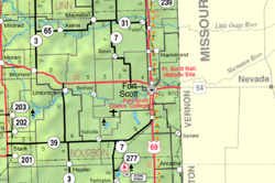
Map of Bourbon Co, Ks, USA.png
Coordinates: 37°49′55″N94°49′29″W / 37.83194°N 94.82472°W / 37.83194; -94.82472 Coordinates: 37°49′55″N94°49′29″W / 37.83194°N 94.82472°W / 37.83194; -94.82472 [1]
Country United States
State Kansas
County Bourbon
Township Marmaton
Incorporated 1858
Elevation
[1]
853 ft (260 m)
Time zone UTC-6 (CST)
  Summer (DST) UTC-5 (CDT)
Area code 620
FIPS code 20-44875 [1]
GNIS ID 474764 [1]

Marmaton is an unincorporated community in Bourbon County, Kansas, United States. [1] The community is located three miles east of Redfield, and two miles south of U.S. Route 54, at the intersection of 155th Street and Limestone Road.

Contents

History

Marmaton was incorporated in 1858. It was named for the Marmaton River, which crosses the township. Marmaton is a corruption of Marmiton, a French name given by fur traders meaning "scullion". [2]

The mailing address for residents of Marmaton is Fort Scott, Kansas.

Geography

The community is located three miles east of Redfield, and two miles south of U.S. Route 54, at the intersection of 155th Street and Limestone Road.

Related Research Articles

<span class="mw-page-title-main">Miami County, Kansas</span> County in Kansas, United States

Miami County is a county located in east-central Kansas and is part of the Kansas City metropolitan area. As of the 2020 census, the county population was 34,191. Its county seat and most populous city is Paola.

<span class="mw-page-title-main">Bourbon County, Kansas</span> County in Kansas, United States

Bourbon County is a county located in Southeast Kansas. As of the 2020 census, the county population was 14,360. Its county seat and most populous city is Fort Scott.

<span class="mw-page-title-main">Allen County, Kansas</span> County in Kansas, United States

Allen County is a county located in the southeast portion of the U.S. state of Kansas. It is 504 square miles, or 322,560 acres in size. As of the 2020 census, the population was 12,526. Its county seat and most populous city is Iola.

<span class="mw-page-title-main">Redfield, Kansas</span> City in Kansas, United States

Redfield is a city in Bourbon County, Kansas, United States. As of the 2020 census, the population of the city was 90.

<span class="mw-page-title-main">U.S. Route 40</span> Highway in the United States

U.S. Route 40 or U.S. Highway 40 (US 40), also known as the Main Street of America, is a major east–west United States Highway traveling across the United States from the Mountain States to the Mid-Atlantic States. As with most routes whose numbers end in a zero, US 40 once traversed the entire United States. It is one of the first U.S. Highways created in 1926 and its original termini were in San Francisco, California, and Atlantic City, New Jersey. US 40 currently ends at a junction with I-80 in Silver Summit, Utah, just outside Salt Lake City. West of this point US 40 was functionally replaced with I-80, and as these segments of I-80 were constructed the western portion of US 40 was truncated several times.

<span class="mw-page-title-main">U.S. Route 281</span> Highway in the United States

U.S. Route 281 (US 281) is a north–south United States Numbered Highway. At 1,875 miles (3,018 km) it is the longest continuous three-digit U.S. Route.

<span class="mw-page-title-main">U.S. Route 54</span> Highway in the United States

U.S. Route 54 is an east–west United States Highway that runs northeast–southwest for 1,197 miles (1,926 km) from El Paso, Texas, to Griggsville, Illinois. The Union Pacific Railroad's Tucumcari Line runs parallel to US 54 from El Paso to Pratt, Kansas, which comprises about two-thirds of the route.

<span class="mw-page-title-main">U.S. Route 56</span>

U.S. Route 56 is an east–west United States highway that runs for approximately 640 miles (1,030 km) in the Midwestern United States. US 56's western terminus is at Interstate 25 Business, US 412 and New Mexico State Road 21 in Springer, New Mexico and the highway's eastern terminus is at US 71 in Kansas City, Missouri. Much of it follows the Santa Fe Trail.

<span class="mw-page-title-main">Pennsylvania Route 54</span> State highway in Pennsylvania, US

Pennsylvania Route 54 is a state highway which runs for 82 miles (132 km) in eastern Pennsylvania. It runs from U.S. Route 15 (US 15), which is three miles (5 km) west of Montgomery, Lycoming County, in the west, to US 209 in Nesquehoning, Carbon County, in the east.

<span class="mw-page-title-main">Lake Afton</span> Body of water

Lake Afton is a 258-acre (104 ha) man-made recreational lake in Sedgwick County, Kansas, United States, and within the 720-acre (2.9 km2) Lake Afton Park. It is located east of the intersection of Viola Rd and MacArthur Rd, between the communities of Goddard, Garden Plain, Schulte, Viola.

<span class="mw-page-title-main">Little Osage River</span> River in Missouri, United States

The Little Osage River is an 88-mile-long (142 km) tributary of the Osage River in eastern Kansas and western Missouri in the United States. Via the Osage and Missouri rivers, it is part of the watershed of the Mississippi River.

<span class="mw-page-title-main">Marmaton River</span> River in Missouri, United States

The Marmaton River (MAR-muh-tuhn) is a 102-mile-long (164 km) tributary of the Little Osage River in southeastern Kansas and western Missouri in the United States. Via the Little Osage, Osage and Missouri rivers, it is part of the watershed of the Mississippi River.

<span class="mw-page-title-main">K-3 (Kansas highway)</span> Highway in Kansas

K-3 is a 43.262-mile-long (69.623 km) state highway in southeastern Kansas that runs through Crawford, Bourbon and Linn counties from K-47 near Girard to K-31 near Blue Mound. It was designated around 1932, and the entire route was paved by 1958. The road is maintained by the Kansas Department of Transportation (KDOT), and is a two-lane road for its entire length. The route's concurrency with U.S. Route 54 (US-54) is a part of the National Highway System.

<span class="mw-page-title-main">Marmaton Township, Bourbon County, Kansas</span> Township in Kansas, United States

Marmaton Township is a township in Bourbon County, Kansas, USA. As of the 2000 census, its population was 815.

<span class="mw-page-title-main">U.S. Route 54 in Kansas</span> Section of U.S. Highway in Kansas

U.S. Route 54 (US-54) is a part of the U.S. Highway System that runs from El Paso, Texas, to Interstate 72 (I-72) in Griggsville, Illinois. In the U.S. state of Kansas, US 54 is a main east–west highway that runs from the Oklahoma border east to the Missouri border.

There are 34 routes assigned to the "S" zone of the California Route Marker Program, which designates county routes in California. The "S" zone includes county highways in Imperial, Orange, Riverside, San Diego, and Santa Barbara counties.

<span class="mw-page-title-main">Aulne, Kansas</span> Unincorporated community in Marion County, Kansas

Aulne is an unincorporated community in Marion County, Kansas, United States. The Aulne name was suggested by officials of the railroad when it was built through Aulne during the 19th century. It is located southwest of Marion at the intersection of Pawnee Road and 140th Street next to the Union Pacific Railroad.

<span class="mw-page-title-main">Milberger, Kansas</span> Unincorporated community in Russell County, Kansas

Milberger is an unincorporated community in Lincoln Township, Russell County, Kansas, United States. It is located about 10.5 miles south of Russell and 3.5 miles west of U.S. Route 281 on Michaelis Rd.

<span class="mw-page-title-main">U.S. Route 59 in Kansas</span>

U.S. Route 59 (US-59) is a part of the U.S. Highway System that runs from the Mexico–US border in Laredo, Texas, as a continuation of Mexican Federal Highway 85D north to the Lancaster–Tolstoi Border Crossing on the Canada–US border, where it continues as Manitoba Highway 59. In the U.S. state of Kansas, US-59 is a main north–south highway that travels from Chetopa to Atchison.

<span class="mw-page-title-main">K-31 (Kansas highway)</span>

K-31 is a 134-mile (216 km) long state highway in the U.S. state of Kansas. K-31 is signed as east–west from US-69 in Fulton to US-59 west of Kincaid and is signed as north–south from US-59 west of Kincaid to K-99 west of Harveyville. K-31 runs diagonally southeast–northwest, connecting small towns in east-central Kansas.

References

  1. 1 2 3 4 5 "Marmaton, Kansas", Geographic Names Information System , United States Geological Survey, United States Department of the Interior
  2. Robley, T. F. (1894). History of Bourbon County, Kansas: To the Close of 1865. Press of the Monitor book & printing Company. pp.  98.

Further reading