Harding, Kansas

Last updated

Harding, Kansas
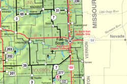
Map of Bourbon Co, Ks, USA.png
Coordinates: 37°59′38″N94°49′11″W / 37.99389°N 94.81972°W / 37.99389; -94.81972 [1]
Country United States
State Kansas
County Bourbon
Elevation
[1]
853 ft (260 m)
Time zone UTC-6 (CST)
  Summer (DST) UTC-5 (CDT)
Area code 620
FIPS code 20-29975 [1]
GNIS ID 474557 [1]

Harding is an unincorporated community in Bourbon County, Kansas, United States. [1]

Contents

History

A post office was established at Harding in 1888, and remained in operation until it was discontinued in 1933. [2] The community was named for Russell Harding, a railroad official. [3]

Related Research Articles

<span class="mw-page-title-main">Neosho County, Kansas</span> County in Kansas, United States

Neosho County is a county located in Southeast Kansas. Its county seat is Erie. As of the 2020 census, the county population was 15,904. The county was named for the Neosho River, which passes through the county.

<span class="mw-page-title-main">Linn County, Kansas</span> County in Kansas, United States

Linn County is a county in the U.S. state of Kansas, located in along the eastern edge of Kansas, and is part of the Kansas City metropolitan area. Its county seat is Mound City, and its most populous city is Pleasanton. As of the 2020 census, the county population was 9,591. The county was named for Lewis Linn, a U.S. Senator from Missouri.

<span class="mw-page-title-main">Crawford County, Kansas</span> County in Kansas, United States

Crawford County is a county located in Southeast Kansas. Its county seat is Girard, and its most populous city is Pittsburg. As of the 2020 census, the county population was 38,972. The county was named in honor of Samuel Crawford, the 3rd governor of Kansas. Pittsburg State University is located in Crawford County.

<span class="mw-page-title-main">Bourbon County, Kansas</span> County in Kansas, United States

Bourbon County is a county located in Southeast Kansas. Its county seat and most populous city is Fort Scott. As of the 2020 census, the county population was 14,360. The county was named after Bourbon County, Kentucky, the former home of many early settlers.

<span class="mw-page-title-main">Anderson County, Kansas</span> County in Kansas, United States

Anderson County is a county located in East Central Kansas, in the Central United States. Its county seat and most populous city is Garnett. As of the 2020 census, the county population was 7,836. The county was named for Joseph C. Anderson, a Kansas territorial legislator and border ruffian during the "Bleeding Kansas" era.

<span class="mw-page-title-main">Mapleton, Kansas</span> City in Kansas, United States

Mapleton is a city in Bourbon County, Kansas, United States. As of the 2020 census, the population of the city was 96.

<span class="mw-page-title-main">Xenia, Kansas</span> Unincorporated community in Kansas, United States

Xenia is an unincorporated community in Franklin Township, Bourbon County, Kansas, United States.

<span class="mw-page-title-main">St. Joseph, Kansas</span> Unincorporated community in Cloud County, Kansas

St. Joseph is an unincorporated community in Cloud County, Kansas, United States.

<span class="mw-page-title-main">National Register of Historic Places listings in Bourbon County, Kansas</span>

This is a list of the National Register of Historic Places listings in Bourbon County, Kansas.

<span class="mw-page-title-main">Garland, Kansas</span> Unincorporated community in Kansas, United States

Garland is an unincorporated community in Bourbon County, Kansas, United States. As of the 2020 census, the population of the community and nearby areas was 31. It is located along the Missouri state line 8.5 miles (13.7 km) southeast of Fort Scott.

<span class="mw-page-title-main">Hiattville, Kansas</span> Unincorporated community in Kansas, United States

Hiattville is an unincorporated community in Bourbon County, Kansas, United States.

<span class="mw-page-title-main">Marmaton, Kansas</span> Unincorporated community in Kansas, United States

Marmaton is an unincorporated community in Bourbon County, Kansas, United States. The community is located three miles east of Redfield, and two miles south of U.S. Route 54, at the intersection of 155th Street and Limestone Road.

<span class="mw-page-title-main">Devon, Kansas</span> Unincorporated community in Kansas, United States

Devon is an unincorporated community in Bourbon County, Kansas, United States. As of the 2020 census, the population of the community and nearby areas was 71.

<span class="mw-page-title-main">Pawnee Station, Kansas</span> Unincorporated community in Kansas, United States

Pawnee Station is an unincorporated community in Bourbon County, Kansas, United States.

<span class="mw-page-title-main">Hammond, Kansas</span> Unincorporated community in Kansas, United States

Hammond is an unincorporated community in Bourbon County, Kansas, United States.

<span class="mw-page-title-main">Berlin, Kansas</span> Unincorporated community in Kansas, United States

Berlin is an unincorporated community in Bourbon County, Kansas, United States.

<span class="mw-page-title-main">Barnesville, Kansas</span> Unincorporated community in Kansas, United States

Barnesville is an unincorporated community in Bourbon County, Kansas, United States.

<span class="mw-page-title-main">Porterville, Kansas</span> Unincorporated community in Kansas, United States

Porterville is an unincorporated community in Bourbon County, Kansas, United States.

<span class="mw-page-title-main">Godfrey, Kansas</span> Unincorporated community in Kansas, United States

Godfrey is an unincorporated community in Bourbon County, Kansas, United States.

<span class="mw-page-title-main">1920 United States presidential election in Kansas</span> Election in Kansas

The 1920 United States presidential election in Kansas was held on November 2, 1920 as part of the 1920 United States presidential election. Kansas voters chose ten electors to the Electoral College, who voted for president and vice president.

References

  1. 1 2 3 4 5 "Harding, Kansas", Geographic Names Information System , United States Geological Survey, United States Department of the Interior
  2. "Kansas Post Offices, 1828-1961". Kansas Historical Society. Retrieved August 2, 2014.
  3. "Many Towns Have Disappeared". The Fort Scott Tribune. July 16, 1976. pp. 3C. Retrieved May 16, 2015.

Further reading