Berlin Township, Steele County, Minnesota

Last updated

Berlin Township, Minnesota
USA Minnesota location map.svg
Red pog.svg
Berlin Township, Minnesota
Location within the state of Minnesota
Usa edcp location map.svg
Red pog.svg
Berlin Township, Minnesota
Berlin Township, Minnesota (the United States)
Coordinates: 43°54′11″N93°19′35″W / 43.90306°N 93.32639°W / 43.90306; -93.32639
Country United States
State Minnesota
County Steele
Area
  Total35.4 sq mi (91.7 km2)
  Land35.1 sq mi (91.0 km2)
  Water0.3 sq mi (0.7 km2)
Elevation
1,224 ft (373 m)
Population
 (2000)
  Total508
  Density14.5/sq mi (5.6/km2)
Time zone UTC-6 (Central (CST))
  Summer (DST) UTC-5 (CDT)
FIPS code 27-05374 [1]
GNIS feature ID0663575 [2]

Berlin Township is a township in Steele County, Minnesota, United States. The population was 508 at the 2000 census.

Contents

Berlin Township was organized in 1857 and named after Berlin, Wisconsin. [3]

Geography

According to the United States Census Bureau, the township has a total area of 35.4 square miles (92 km2), of which 35.1 square miles (91 km2) is land and 0.3 square miles (0.78 km2) (0.76%) is water.

Demographics

As of the census [1] of 2000, there were 508 people, 189 households, and 150 families residing in the township. The population density was 14.5 inhabitants per square mile (5.6/km2). There were 268 housing units at an average density of 7.6 per square mile (2.9/km2). The racial makeup of the township was 99.41% White, 0.20% Asian, and 0.39% from two or more races. Hispanic or Latino of any race were 1.38% of the population.

There were 189 households, out of which 31.2% had children under the age of 18 living with them, 70.9% were married couples living together, 2.6% had a female householder with no husband present, and 20.6% were non-families. 18.0% of all households were made up of individuals, and 7.9% had someone living alone who was 65 years of age or older. The average household size was 2.69, and the average family size was 3.05.

In the township, the population was spread out, with 26.2% under the age of 18, 5.9% from 18 to 24, 28.5% from 25 to 44, 26.6% from 45 to 64, and 12.8% who were 65 years of age or older. The median age was 40 years. For every 100 females, there were 119.9 males. For every 100 females age 18 and over, there were 115.5 males.

The median income for a household in the township was $47,083, and the median income for a family was $55,000. Males had a median income of $32,500 versus $25,714 for females. The per capita income for the township was $18,764. About 6.3% of families and 10.7% of the population were below the poverty line, including 12.3% of those under age 18 and 7.5% of those age 65 or over.

Related Research Articles

Burlington Township is a civil township of Lapeer County in the U.S. state of Michigan. The population was 1,478 at the 2010 Census.

Mahtowa Township is a township in Carlton County, Minnesota, United States. The population was 494 as of the 2000 census. The name Mahtowa was derived from a Native American term meaning "bear" or "grass lands".

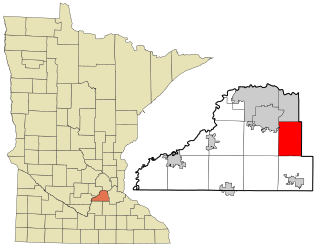
Havelock Township is a township in Chippewa County, Minnesota, United States. The population was 189 at the 2000 census.

Rose Hill Township is a township in Cottonwood County, Minnesota, United States. The population was 166 at the 2010 census.

Bay Lake Township is a township in Crow Wing County, Minnesota, United States. The population was 923 at the 2000 census. This township took its name from Bay Lake.

Hokah Township is a township in Houston County, Minnesota, United States. The population was 545 at the 2000 census.

Bearville Township is a township in Itasca County, Minnesota, United States. The population was 205 at the 2010 census.

Culdrum Township is a township in Morrison County, Minnesota, United States. The population was 505 at the 2000 census.

Green Prairie Township is a township in Morrison County, Minnesota, United States. The population was 665 at the 2000 census.

Swan River Township is a township in Morrison County, Minnesota, United States. The population was 755 at the 2000 census.

Farmington Township is a township in Olmsted County, Minnesota, United States. The population was 516 at the 2000 census.

Effington Township is a township in Otter Tail County, Minnesota, United States. The population was 297 at the 2000 census.

Cedar Lake Township is a township in Scott County, Minnesota, United States. The population was 2,197 at the 2000 census.

<span class="mw-page-title-main">Credit River, Minnesota</span> City in Minnesota, United States

Credit River is a city in Scott County, Minnesota, United States. The population was 5,493 at the 2020 census.

Helena Township is a township in Scott County, Minnesota, United States. The population was 1,440 at the 2000 census.

Jackson Township is a township in Scott County, Minnesota, United States. Organized in 1858, Jackson Township's population was 1,361 at the 2000 census. While the origin of its name is not recorded, it is most likely named after President Andrew Jackson.

Louisville Township is a township in Scott County, Minnesota, United States. The population was 1,359 at the 2000 census.

Van Buren Township is a township in Saint Louis County, Minnesota, United States. It was named for Martin Van Buren, the eighth President of the United States. The population was 189 at the 2010 census.

Deerfield Township is a township in Steele County, Minnesota, United States. The population was 693 at the 2000 census.

Medford Township is a township in Steele County, Minnesota, United States. The population was 681 at the 2000 census.

References

  1. 1 2 "U.S. Census website". United States Census Bureau . Retrieved January 31, 2008.
  2. "US Board on Geographic Names". United States Geological Survey. October 25, 2007. Retrieved January 31, 2008.
  3. Upham, Warren (1920). Minnesota Geographic Names: Their Origin and Historic Significance. Minnesota Historical Society. p.  531.