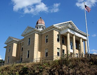
Steele County is a county in the U.S. state of Minnesota. As of the 2010 United States Census, the population was 36,576. Its county seat is Owatonna.

Hennepin County is a county in the U.S. state of Minnesota. As of the 2010 census the population was 1,152,425. It is the most populous county in Minnesota and the 32nd-most populous county in the United States; more than one in five Minnesotans live in Hennepin County. Its county seat is Minneapolis, the state's most populous city. The county is named in honor of the 17th-century explorer Father Louis Hennepin. Hennepin County is included in the Minneapolis-St. Paul-Bloomington Metropolitan Statistical Area. The center of population of Minnesota is in Hennepin County, in the city of Minneapolis.

Dodge County is a county in the U.S. state of Minnesota. The population was 20,087 as of the 2010 United States Census. Its county seat is Mantorville.

Owatonna is a city in Steele County, Minnesota, United States. The population was 25,599 at the 2010 census. It is the county seat of Steele County. Owatonna is home to the Steele County Fairgrounds, which hosts the Steele County Free Fair in August.

Fort Snelling, originally known as Fort Saint Anthony, is a United States military fortification located at the confluence of the Minnesota and Mississippi rivers in Hennepin County, Minnesota. The Mississippi National River and Recreation Area, a National Park Service unit, includes historic Fort Snelling.
The Steele County Free Fair is an annual week-long summer county fair held in Owatonna, Minnesota, United States, the county seat of Steele County. It is the largest free county fair in Minnesota, displaying over 2,000 animals each year and hosting over 450 vendors who sell food, commercial goods and services, and arts and crafts.

Pratt is an unincorporated community in Steele County, Minnesota, United States.

The Straight River is a tributary of the Cannon River, 55.6 miles (89.5 km) long, in southeastern Minnesota in the United States. Via the Cannon River, it is part of the watershed of the Mississippi River, draining an area of approximately 450 square miles (1,200 km2) in an agricultural region.

Moland is an unincorporated community in Rice and Steele counties in the U.S. state of Minnesota.

Rice Lake is a ghost town in Dodge and Steele counties in the U.S. state of Minnesota. It is located east of Owatonna, and just north of Rice Lake State Park. The nearest community is the city of Claremont, to the southeast. The Dodge County portion lies in the southwest corner of Ellington Township, while the Steele County portion lies in the southeast corner of Merton Township.

Hope is an unincorporated community in Somerset Township, Steele County, Minnesota, United States. Although it is unincorporated, Hope has a post office with ZIP code 56046.

Bixby is an unincorporated community in Aurora Township, Steele County, Minnesota, United States.

Clinton Falls is an unincorporated community in Clinton Falls Township, Steele County, Minnesota, United States.

Saco is an unincorporated community in Somerset Township, Steele County, Minnesota, United States, near Owatonna and Hope. The community is located near the junction of Steele County Roads 31 and 32.

Merton is an unincorporated community in Merton Township, Steele County, Minnesota, United States, near Medford and Owatonna. The community is located near the junction of Steele County Roads 8 and 9. Other nearby routes include Steele County Roads 10, 12, and 37. Medford Creek and Rush Creek both flow nearby.

Meriden is an unincorporated community in Meriden Township, Steele County, Minnesota, United States, near Owatonna and Waseca. The community is located along SW 92nd Avenue near SW 13th Street.

Litomysl is an unincorporated community in Somerset Township, Steele County, Minnesota, United States. The community is located near the junction of Steele County Roads 4 and 27. Nearby places include Hope, Bixby, and Owatonna.

Lemond is an unincorporated community in Lemond Township, Steele County, Minnesota, United States, near Owatonna and Ellendale. The community is located near the junction of Steele County Roads 4 and 7, and SW 89th Avenue.

Havana is an unincorporated community in Havana Township, Steele County, Minnesota, United States, near Owatonna. The community is located along SE 44th Avenue near SE 18th Street.

Deerfield is an unincorporated community in Deerfield Township, Steele County, Minnesota, United States, near Medford and Owatonna. The community is located along NW 66th Street near NW 73rd Avenue. Mackenzies Creek and Mud Creek both flow nearby.


