Havana, Minnesota

Last updated

Havana
USA Minnesota location map.svg
Red pog.svg
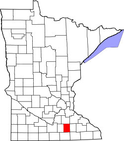
Havana
Location of the community of Havana
within Havana Township, Steele County
Usa edcp location map.svg
Red pog.svg
Havana
Havana (the United States)
Coordinates: 44°03′59″N93°08′47″W / 44.06639°N 93.14639°W / 44.06639; -93.14639
Country United States
State Minnesota
County Steele
Township Havana Township
Elevation
1,224 ft (373 m)
Time zone UTC-6 (Central (CST))
  Summer (DST) UTC-5 (CDT)
ZIP code
55060
Area code 507
GNIS feature ID644729 [1]

Havana is an unincorporated community in Havana Township, Steele County, Minnesota, United States, near Owatonna. The community is located along SE 44th Avenue near SE 18th Street.

History

Havana was platted in 1867, when the Winona and St. Peter Railroad was extended to that point. [2] The community was named after Havana, Illinois. [3] A post office was established at Havanna in 1869, and remained in operation until 1911. [4]

Related Research Articles

<span class="mw-page-title-main">Byron, Minnesota</span> City in Minnesota, United States

Byron is a city in Olmsted County, Minnesota, United States, approximately five miles (8 km) west of Rochester on U.S. Route 14. It is surrounded by Kalmar Township. The population was 6,312 at the 2020 census.

Viola is an unincorporated community in Viola Township, Olmsted County, Minnesota, United States. It is the site of a yearly Gopher Count festival, which began in 1874.

Pratt is an unincorporated community in Steele County, Minnesota, United States.

Verdi is an unincorporated community located in Verdi Township, Lincoln County, Minnesota, United States. The altitude is 1,762 feet. Verdi is seen on the Verdi US Geological Survey Map.

Douglas is an unincorporated community in Olmsted County, Minnesota, United States. The community is located along 75th Street NW near its junction with County Road 3. Douglas is located within Kalmar Township and New Haven Township. Nearby places include Oronoco, Rochester, and the Douglas State Trail. The community is about two miles from the city of Rochester.

Ash Creek is an unincorporated community in Clinton Township, Rock County, Minnesota, United States. The community took its name from nearby Ash Creek, a tributary of the Rock River.

Brill is an unincorporated community located in Barron County, Wisconsin, United States. Brill is east of Haugen, in the town of Oak Grove.

Essig is an unincorporated community in Brown County, Minnesota, United States. Essig is located on U.S. Route 14, 7 miles (11 km) west of New Ulm. Essig has a post office with ZIP code 56030.

Hope is an unincorporated community in Somerset Township, Steele County, Minnesota, United States. Hope has a post office with ZIP code 56046.

<span class="mw-page-title-main">Bluff Siding, Wisconsin</span> Unincorporated community in Wisconsin, United States

Bluff Siding or Atlanta Station is an unincorporated community located in the town of Buffalo, in Buffalo County, Wisconsin, United States.

<span class="mw-page-title-main">Miloma, Minnesota</span> Unincorporated community in Minnesota, United States

Miloma is an unincorporated community located in Jackson County, Minnesota, United States at latitude 43.763 and longitude -95.368. The elevation is 1,427 feet. Miloma appears on the Heron Lake U.S. Geological Survey Map.

<span class="mw-page-title-main">Lime Creek, Minnesota</span> Unincorporated community in Minnesota, United States

Lime Creek is an unincorporated community in Belfast Township, Murray County, Minnesota, United States. It is located two miles northeast of Fulda.

<span class="mw-page-title-main">Marshland, Wisconsin</span> Unincorporated community in Wisconsin, United States

Marshland is an unincorporated community located in the town of Buffalo, in Buffalo County, Wisconsin, United States. Marshland is located on Wisconsin Highway 35 and Wisconsin Highway 54 8.5 miles (13.7 km) east-southeast of Fountain City.

Hersey is an unincorporated community located in the town of Springfield, St. Croix County, Wisconsin, United States. Hersey is located along the Union Pacific Railroad 2 miles (3.2 km) north-northwest of Wilson.

Chester is an unincorporated community in Marion Township, Olmsted County, Minnesota, United States. It is located immediately east of Rochester along U.S. Highway 14 near Olmsted County Roads 19 and 119. Chester Woods Park is nearby.

Claybank is an unincorporated community in Goodhue Township, Goodhue County, Minnesota, United States.

Blakeley is an unincorporated community in Blakeley Township, Scott County, Minnesota, United States, along the Minnesota River. The community is located west-southwest of Belle Plaine near the junction of Scott County Roads 1, 6, and 60.

Amiret is an unincorporated community in Lyon County, in the U.S. state of Minnesota.

Meriden is an unincorporated community in Meriden Township, Steele County, Minnesota, United States, near Owatonna and Waseca. The community is located along SW 92nd Avenue near SW 13th Street.

Smiths Mill is an unincorporated community in Blue Earth and Waseca counties in the U.S. state of Minnesota. The community is located along 631st Avenue near 206th Street and U.S. Highway 14. Smiths Mill is located within Le Ray Township in Blue Earth County; and also located within Janesville Township in Waseca County. Nearby places include Janesville and Eagle Lake.

References

  1. "Havana, Minnesota". Geographic Names Information System . United States Geological Survey, United States Department of the Interior.
  2. Upham, Warren (1920). Minnesota Geographic Names: Their Origin and Historic Significance. Minnesota Historical Society. p. 532.
  3. Chicago and North Western Railway Company (1908). A History of the Origin of the Place Names Connected with the Chicago & North Western and Chicago, St. Paul, Minneapolis & Omaha Railways. p. 82.
  4. "Steele County". Jim Forte Postal History. Retrieved March 20, 2015.