Bixby, Minnesota

Last updated

Bixby
USA Minnesota location map.svg
Red pog.svg
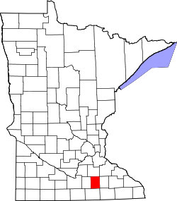
Bixby
Location of the community of Bixby
within Aurora Township, Steele County
Usa edcp location map.svg
Red pog.svg
Bixby
Bixby (the United States)
Coordinates: 43°56′40″N93°05′50″W / 43.94444°N 93.09722°W / 43.94444; -93.09722
Country United States
State Minnesota
County Steele
Township Aurora Township
Elevation
1,302 ft (397 m)
Time zone UTC-6 (Central (CST))
  Summer (DST) UTC-5 (CDT)
ZIP code
55917
Area code 507
GNIS feature ID654606 [1]

Bixby is an unincorporated community in Aurora Township, Steele County, Minnesota, United States.

Contents

Geography

Bixby is located between Blooming Prairie and Owatonna along U.S. Highway 218 near its intersection with Steele County Road 4.

Nearby places include Blooming Prairie, Owatonna, Hope, Claremont, and Oak Glen Lake. County Roads 16 and 26 are also in the immediate area.

History

Bixby was laid out in about 1890. [2] The community is named in honor of John Bixby (1814–1890), a pioneer who settled near the town site. [2] A post office was established at Bixby in 1889, and remained in operation until 1982. [3]

Related Research Articles

<span class="mw-page-title-main">Steele County, Minnesota</span> County in Minnesota, United States

Steele County is a county in the U.S. state of Minnesota. As of the 2020 census, the population was 37,406. Its county seat is Owatonna.

Blooming Prairie Township is a township in Steele County, Minnesota, United States. The population was 519 at the 2000 census.

<span class="mw-page-title-main">Owatonna, Minnesota</span> City in Minnesota, United States

Owatonna is a city in Steele County, Minnesota, United States. The population was 26,420 at the 2020 census. It is the county seat of Steele County. Owatonna is home to the Steele County Fairgrounds, which hosts the Steele County Free Fair in August.

<span class="mw-page-title-main">Blooming Prairie, Minnesota</span> City in Minnesota, United States

Blooming Prairie is a city in Dodge and Steele counties in the U.S. state of Minnesota. The population was 1,996 at the 2010 census. Most of the city is located within Steele County; only a small part of the city extends into Dodge County.

Blooming Prairie can refer to a location in the United States:

<span class="mw-page-title-main">U.S. Route 218</span> Highway in the United States

U.S. Highway 218 (US 218) is an original United States Highway that was created in 1926. Although technically a spur of US 18, US 218 neither begins nor ends at US 18, but overlaps US 18 for eight miles (13 km) near Charles City, Iowa. US 218 begins at U.S. 136 in downtown Keokuk and ends 319 miles (513 km) away at Interstate 35 (I-35) and US 14 at Owatonna, Minnesota. A large portion of US 218 in Iowa is part of the Avenue of the Saints, which connects St. Louis, Missouri, and Saint Paul, Minnesota.

Pratt is an unincorporated community in Steele County, Minnesota, United States.

<span class="mw-page-title-main">Straight River (southern Minnesota)</span> River in Minnesota, United States

The Straight River is a tributary of the Cannon River, 55.6 miles (89.5 km) long, in southeastern Minnesota, United States. Via the Cannon River, it is part of the watershed of the Mississippi River, draining an area of approximately 450 square miles (1,200 km2) in an agricultural region.

Hope is an unincorporated community in Somerset Township, Steele County, Minnesota, United States. Hope has a post office with ZIP code 56046.

<span class="mw-page-title-main">National Register of Historic Places listings in Steele County, Minnesota</span>

This is a list of the National Register of Historic Places listings in Steele County, Minnesota. It is intended to be a complete list of the properties and districts on the National Register of Historic Places in Steele County, Minnesota, United States. The locations of National Register properties and districts for which the latitude and longitude coordinates are included below, may be seen in an online map.

<span class="mw-page-title-main">Maple Island, Freeborn County, Minnesota</span> Unincorporated community in Minnesota, United States

Maple Island is an unincorporated community in Freeborn County, Minnesota, United States. It is located within Newry Township and Moscow Township.

Clinton Falls is an unincorporated community in Clinton Falls Township, Steele County, Minnesota, United States.

Steele Center is an unincorporated community in Somerset Township, Steele County, Minnesota, United States. The community is located south of Owatonna near the junction of Steele County Roads 3 and 45, and 68th Street.

Saco is an unincorporated community in Somerset Township, Steele County, Minnesota, United States, near Owatonna and Hope. The community is located near the junction of Steele County Roads 31 and 32.

Merton is an unincorporated community in Merton Township, Steele County, Minnesota, United States, near Medford and Owatonna. The community is located near the junction of Steele County Roads 8 and 9. Other nearby routes include Steele County Roads 10, 12, and 37. Medford Creek and Rush Creek both flow nearby.

Meriden is an unincorporated community in Meriden Township, Steele County, Minnesota, United States, near Owatonna and Waseca. The community is located along SW 92nd Avenue near SW 13th Street.

Litomysl is an unincorporated community in Somerset Township, Steele County, Minnesota, United States. The community is located near the junction of Steele County Roads 4 and 27. Nearby places include Hope, Bixby, and Owatonna.

Lemond is an unincorporated community in Lemond Township, Steele County, Minnesota, United States, near Owatonna and Ellendale. The community is located near the junction of Steele County Roads 4 and 7, and SW 89th Avenue.

Havana is an unincorporated community in Havana Township, Steele County, Minnesota, United States, near Owatonna. The community is located along SE 44th Avenue near SE 18th Street.

Deerfield is an unincorporated community in Deerfield Township, Steele County, Minnesota, United States, near Medford and Owatonna. The community is located along NW 66th Street near NW 73rd Avenue. Mackenzies Creek and Mud Creek both flow nearby.

References

  1. "Bixby, Minnesota". Geographic Names Information System . United States Geological Survey, United States Department of the Interior.
  2. 1 2 Upham, Warren (1920). Minnesota Geographic Names: Their Origin and Historic Significance. Minnesota Historical Society. p.  532.
  3. "Steele County". Jim Forte Postal History. Retrieved August 9, 2015.