Bhavanipuram

Last updated

Bhavanipuram
Neighbourhood
Bhavani Puram.webp
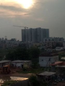
View of Bhavanipuram
India Andhra Pradesh location map (current).svg
Red pog.svg
Bhavanipuram
Location in Andhra Pradesh, India
Coordinates: 16°30′40″N80°38′24″E / 16.511°N 80.64°E / 16.511; 80.64
CountryFlag of India.svg  India
State Andhra Pradesh
District NTR
Mandal Vijayawada West
City Vijayawada
Metro Andhra Pradesh Capital Region
Government
  Type Mayor–Council
  Body Vijayawada Municipal Corporation
Languages
  Official Telugu
Time zone UTC+5:30 (IST)
PIN
520012
Telephone code0866
Vehicle registration AP16
Lok Sabha constituency Vijayawada

Bhavanipuram is a residential hub located to the West Central of Vijayawada in Andhra Pradesh, India. The locality shares its borders with Vijayawada Bypass Road and National Highway 65. Though consisting of vacant plots till a few years back, the area now consists of commercial and residential establishments. Popular areas located close to Bhavanipuram include Undavalli, Krishna Lanka, Gollapudi, Jakkampudi, Vidyadarapuram, Chitti Nagar, and Kabela. [1] [2]

Contents

Transport

Bhavanipuram is well connected to other parts of the city by City buses run by APSRTC 23H Penamaluru to BhavaniPuram H.B colony.

History

Until the early 1990s, the area mostly consisted of vacant plots, estates and roadside restaurants to serve the traffic along NH9 headed to Bombay. Commercial activity first shifted here from the center of the city in the 1990s with the expansion of the western suburbs of Vijayawada due to ongoing construction activity in the area and its surrounding areas.

Related Research Articles

<span class="mw-page-title-main">Vijayawada</span> Metropolis in Andhra Pradesh, India

Vijayawada, formerly known as Bezawada, is the second largest city in the Indian state of Andhra Pradesh. It is located on the banks of the Krishna River surrounded by the hills of the Eastern Ghats, known as the Indrakeeladri Hills. The city is home to the important Hindu shrine of Kanaka Durga Temple. It geographically lies on the center spot of Andhra Pradesh. The city has been described as the commercial, political, cultural and educational capital of Andhra Pradesh. It is the administrative headquarters of NTR district. The Prakasam Barrage across the Krishna River connects the NTR and Guntur districts.

A residential community is a community, usually a small town or city, that is composed mostly of residents, as opposed to commercial businesses and/or industrial facilities, all three of which are considered to be the three main types of occupants of the typical community.

<span class="mw-page-title-main">Hintonburg</span> Neighbourhood in Ottawa, Ontario, Canada

Hintonburg is a neighbourhood in Kitchissippi Ward in Ottawa, Ontario, Canada, located west of the Downtown core. It is a historically working-class, predominantly residential neighbourhood, with a commercial strip located along Wellington Street West. It is home to the Parkdale Farmer's Market, located along Parkdale Avenue, just north of Wellington. It is considered to be one of Ottawa's most "hipster" neighbourhoods.

<span class="mw-page-title-main">Nazimabad</span> Neighborhood of Karachi

Nazimabad is a suburb of Karachi, Pakistan. It was established in 1952, and is named after the second Governor General of Pakistan Khawaja Nazimuddin. Nazimabad is located in Nazimabad Town. One of the largest government own hospitals in Karachi namely Abbasi Shaheed Hospital also situated in Nazimabad. The Abbasi Shaheed Hospital has 24/7 emergency/trauma facility. The Karachi Matriculation Board is also located in Nazimabad. The highly populated colony Paposh Nagar is also located in Nazimabad.

<span class="mw-page-title-main">The Highlands, Louisville</span>

The Highlands is an area in Louisville, Kentucky which contains a high density of nightclubs, eclectic businesses, and many upscale and fast food restaurants. It is centered along a three-mile (5 km) stretch of Bardstown Road and Baxter Avenue and is so named because it sits atop a ridge between the middle and south forks of Beargrass Creek. The commercial area extends from the intersection of Bardstown Road and Taylorsville Road/Trevillian Way in the south, to the intersection of Baxter Avenue and Lexington Road in the north, a length of 3.2 miles (5.1 km). A 12-mile (800 m) section of the nearby Barret Avenue also contains many similar businesses. The residential area is separated from other adjacent areas like Germantown and Crescent Hill by the south and north forks of Beargrass Creek. The middle fork runs through Cherokee Park, and the south fork divides Germantown from Tyler Park, after flowing past several cemeteries and undeveloped forests downstream from Joe Creason Park. Due to its large collection of night clubs and restaurants, it is locally known as "Restaurant Row".

Garden Town is a residential neighborhood and union council located in Gulberg Tehsil of Lahore, Punjab, Pakistan.

<span class="mw-page-title-main">Museum Planning Area</span> Planning Area in Central Region ----, Singapore

The Museum Planning Area is a planning area located in the Central Area of the Central Region of Singapore. The area plays a "bridging role" between the Orchard area and the Downtown Core, which necessitates proper transport networks for vehicles, pedestrians and public transport. Due to the sheer size of green areas in the district, the Urban Redevelopment Authority (URA) has designated it a 'green lung' in the Central Area. However, the Museum Planning Area is also home to cultural and commercial activities. Around 65% of the area is available for future development, making it a hotbed for new infrastructure and buildings.

<span class="mw-page-title-main">Downtown Norfolk, Virginia</span> Central Business District

Downtown Norfolk serves as the traditional center of commerce, government, and culture in the Hampton Roads region. Norfolk, Virginia's downtown waterfront shipping and port activities historically played host to numerous and often noxious port and shipping-related uses. With the advent of containerized shipping in the mid-19th century, the shipping uses located on Norfolk's downtown waterfront became obsolete as larger and more modern port facilities opened elsewhere in the region. The vacant piers and cargo warehouses eventually became a blight on downtown and Norfolk's fortunes as a whole. But in the second half of the century, Norfolk had a vibrant retail community in its suburbs; companies like Smith & Welton, High's, Colonial Stores, Goldman's Shoes, Lerner Shops, Hofheimer's, Giant Open Air, Dollar Tree and K & K Toys were regional leaders in their respective fields. Norfolk was also the birthplace of Econo-Travel, now Econo Lodge, one of the nation's first discount motel chains.

<span class="mw-page-title-main">Ameerpet</span> Neighbourhood in Hyderabad District, Telangana, India

Ameerpet is a residential hub located in the north-west part of Hyderabad, Telangana. Ameerpet is also a Mandal in Hyderabad District. The locality shares its borders with Sardar Patel Road and the National Highway 65. Though consisting of vacant plots till a few years back, the area is now bustling with some commercial and residential establishments.

<span class="mw-page-title-main">Dubai Maritime City</span>

Dubai Maritime City (DMC) is a multipurpose maritime zone. It is a member of the DP World group of companies. Maritime city was expected to be fully operational by 2012, and by January 2021 had completed 80% of the first phase's infrastructure works. In February 2022 it was announced that DP World would launch a major project to develop DMC's infrastructure at a cost of Dh140 million. The industrial part of Dubai Maritime City is fully operational, with a large number of business partners operating from DMC. The industrial precinct is active and consists of marine services primarily dealing with ship lifts, ship repair plots, warehouses, workshops, as well as supporting retail and showrooms.

<span class="mw-page-title-main">Runnymede, Toronto</span> Neighbourhood in Toronto, Ontario, Canada

Runnymede is a neighbourhood in Toronto, Ontario, Canada located north of Bloor Street West between Jane Street and Runnymede Road north to Dundas Street West. It is located directly north of the former village of Swansea and west of the High Park North neighbourhood. The immediate area around Bloor Street is commonly known as Bloor West Village after the shopping area along Bloor Street, whereas the area to the north is considered the Runnymede neighbourhood.

<span class="mw-page-title-main">Madhurawada</span> Neighbourhood in Visakhapatnam, Andhra Pradesh, India

Madhurawada is a major business and residential area of Visakhapatnam in the state of Andhra Pradesh. It is located on the Visakhapatnam-Vizianagaram stretch of National Highway 16 around 16 km from the city center of Visakhapatnam.

Police Line Area, also known as PLA is a residential and commercial suburb located in Hisar city of Haryana, India. The planning of the area is administered by Haryana Urban Development Authority (HUDA).

Castaic Union School District is a public school district serving unincorporated Castaic, portions of unincorporated Valencia, and a very small portion of the city of Santa Clarita within Los Angeles County, California, offering elementary and secondary instruction, grades pre-K through eighth. Until 1890, it was known as the "Castec School District."

<span class="mw-page-title-main">Mogalrajapuram</span> City Centre in Andhra Pradesh, India

Mogalrajapuram is a major residential and commercial area in Vijayawada. It is one of the shopping district of the city. It is located at centre of Vijayawada beside low range hills.The area consists of many shopping malls.The area is well connected to the other places of city Suryaraopet, Governorpet, Beasent Road, Gunadala, Benz circle Ramavarappadu

<span class="mw-page-title-main">Vijayawada Municipal Corporation</span> Local civic body in Vijayawada, Andhra Pradesh, India

Vijayawada Municipal Corporation (VMC) is the civic body that governs the city of Vijayawada, second largest city in the Indian state of Andhra Pradesh.

<span class="mw-page-title-main">New Borg El Arab</span> City in Alexandria, Egypt

New Borg El Arab is a new Egyptian city of the first generation, located in Alexandria Governorate, and administratively affiliated to the New Urban Communities Authority. It was established by decree of the President of the Arab Republic of Egypt No. 506 dated December 5, 1979 under the name" New Amria City", and it remained in that name until the decision of the Chairman of the council was issued. Ministers No. 1532 dated July 31, 1989 amending its name to become the New Borg El Arab city, with a total area of 47,403 acres (191 km2), about 55 km away from Alexandria, about 8 km from the Mediterranean coast and the Alexandria Matrouh coastal road, and about 3 km from Borg El Arab.

<span class="mw-page-title-main">World Trade Center Chennai</span> Skyscraper office buildings in Chennai

The Brigade World Trade Center, Chennai is a 28-storeyed commercial and residential centre in Chennai, India. Located at Perungudi, it was made operational in March 2020. The centre consists of 170,000 square metres (1,800,000 sq ft) of office space. The complex also includes a conference/exhibition centre. The towers are IGBC LEED Platinum and USGBC LEED Gold certified. The centre is a member of the World Trade Centers Association (WTCA). The Tower A of the WTC complex is the tallest commercial establishment in the city.

<span class="mw-page-title-main">Northland (Columbus, Ohio)</span> Neighborhood in Columbus, Ohio

Northland is a residential and commercial area in northeast Columbus, Ohio. The area is served by the Northland Community Council, which oversees land east of Worthington, roughly north of Morse Road, south of I-270, and west of New Albany, including the neighborhood Forest Park and the independent village of Minerva Park.

References

  1. Ameen, Md (17 January 2022). "Vijayawada: Commercial activity on rise in Bhavanipuram". www.thehansindia.com. Retrieved 30 October 2022.
  2. "Census" (PDF).