Bigelow, Kansas

Last updated
Bigelow, Kansas
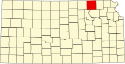
Map of Marshall Co, Ks, USA.png
USA Kansas location map.svg
Red pog.svg
Bigelow
Usa edcp location map.svg
Red pog.svg
Bigelow
Coordinates: 39°38′0″N96°30′16″W / 39.63333°N 96.50444°W / 39.63333; -96.50444 [1]
Country United States
State Kansas
County Marshall
Founded1881
Named for Alfred Bigelow
Elevation
[1]
1,175 ft (358 m)
Population
  Total0
Time zone UTC-6 (CST)
  Summer (DST) UTC-5 (CDT)
Area code 785
GNIS ID 481833 [1]

Bigelow is a ghost town in Marshall County, Kansas, United States. [1] It was located six and a half miles southwest of Frankfort.

Contents

History

It was founded in 1881 [2] and named for General Alfred Bigelow. [3] It was known for its limestone quarries and peaked in population in 1910 at 200. [4]

The post office closed in 1960 and the town was demolished during the construction of Tuttle Creek Lake. All that remains is a historical marker at the intersection of 17th and Zenith Roads and Antioch Cemetery.

Related Research Articles

<span class="mw-page-title-main">Marshall County, Kansas</span> County in Kansas, United States

Marshall County is a county located in the U.S. state of Kansas. Its county seat and largest city is Marysville. As of the 2020 census, the county population was 10,038. The county was named after Frank J. Marshall, a state representative who operated the first ferry over the Big Blue River.

<span class="mw-page-title-main">Gove County, Kansas</span> County in Kansas, United States

Gove County is a county in the U.S. state of Kansas. Its county seat is Gove City, and its most populous city is Quinter. As of the 2020 census, the county population was 2,718. The county was named for Granville Gove, a captain of Company G of the 11th Kansas Cavalry Regiment Volunteer Cavalry, who died from battle wounds during the American Civil War.

<span class="mw-page-title-main">Kansas's 1st congressional district</span> U.S. House district for Kansas

Kansas's 1st congressional district is a congressional district in the U.S. state of Kansas. Commonly known as "The Big First", the district encompasses all or part of 60 counties spanning more than half of the state, making it the seventh-largest district in the nation that does not cover an entire state.

<span class="mw-page-title-main">Doniphan, Kansas</span> Unincorporated community in Doniphan County, Kansas

Doniphan is an unincorporated community in Doniphan County, Kansas, United States.

<span class="mw-page-title-main">Lillis, Kansas</span> Unincorporated community in Marshall County, Kansas

Lillis is an unincorporated community in Marshall County, Kansas, United States.

<span class="mw-page-title-main">Asherville, Kansas</span> Unincorporated community in Mitchell County, Kansas

Asherville is an unincorporated community in Mitchell County, Kansas, United States. As of the 2020 census, the population of the community and nearby areas was 19.

Cofachique is a ghost town situated along the Neosho River near the present-day city of Iola in Allen County, Kansas, United States. Being the first town established in Allen County in 1855, it was the original county seat. However, within five years the greater part of the town was moved to the new town of Iola, while the old site of Cofachique became farm land. The town was named in honor of an Osage chief known as Cofachique, who is said to have been particularly helpful to early settlers, bringing aid to the distressed and homeless. The name "Cofachique" appears to have origins with the Cofachiqui tribe in South Carolina, who were Siouan speakers, and the Osage who settled this area were closely affiliated with the Siouan.

<span class="mw-page-title-main">Iowa Point, Kansas</span> Unincorporated community in Doniphan County, Kansas

Iowa Point is an unincorporated community in northeastern Doniphan County, Kansas, United States.

<span class="mw-page-title-main">Galt, Kansas</span> Ghost town in Kansas, United States

Galt is a ghost town in central Galt Township, Rice County, Kansas, United States. It was located near the Little Arkansas River, 6 miles (9.7 km) southeast of Geneseo and 14 miles (23 km) northeast of Lyons.

<span class="mw-page-title-main">Irving, Kansas</span> Ghost town in Marshall County, Kansas

Irving is a ghost town in Marshall County, Kansas, United States, located six miles southeast of the city of Blue Rapids along the Big Blue River. Irving was one of the many towns affected by "Big Dam Foolishness" during the construction of Tuttle Creek Lake about ten miles to the south. Although the lake never reached the town, the federal government forced remaining residents to vacate the town.

White Rock is a ghost town in Republic County, Kansas, United States. It is located 6 miles (9.7 km) north of Courtland.

<span class="mw-page-title-main">Black Wolf, Kansas</span> Unincorporated community in Ellsworth County, Kansas

Black Wolf is an unincorporated community in Ellsworth County, Kansas, United States. It is approximately 6 miles (9.7 km) west of Ellsworth.

<span class="mw-page-title-main">Farmington, Kansas</span> Unincorporated community in Kansas, United States

Farmington is an unincorporated community in Atchison County, Kansas, United States.

Bayneville is an unincorporated community in Ohio Township, Sedgwick County, Kansas, United States. It is located on S 87th W between W 71st S and W 79st S.

<span class="mw-page-title-main">Marietta, Kansas</span> Unincorporated community in Marshall County, Kansas

Marietta is an unincorporated community in Marshall County, Kansas, United States.

<span class="mw-page-title-main">Vliets, Kansas</span> Unincorporated community in Marshall County, Kansas

Vliets is an unincorporated community in Marshall County, Kansas, United States. It is located at the southern terminus of Kansas Highway 87.

<span class="mw-page-title-main">Ewell, Kansas</span> Ghost town in Kansas, U.S.

Ewell is a ghost town in Sumner County, Kansas, United States. It is located about 3.5 miles southwest of Conway Springs at 0.25 mile southeast of the intersection of N Bluff Rd and W 60th Ave N, next to an abandoned railroad.

Mount Pleasant is a ghost town in Atchison County, Kansas, United States. It was located approximately 1.5 miles north of Potter along Rawlins Rd.

<span class="mw-page-title-main">Comiskey, Kansas</span> Ghost town in Morris County, Kansas

Comiskey is a ghost town in Morris County, Kansas, United States. It was located approximately 6 miles (9.7 km) east of Council Grove, next to the county line.

References

  1. 1 2 3 4 "Bigelow, Kansas", Geographic Names Information System , United States Geological Survey, United States Department of the Interior
  2. Blackmar, Frank Wilson (1912). Kansas: A Cyclopedia of State History, Embracing Events, Institutions, Industries, Counties, Cities, Towns, Prominent Persons, Etc. Standard Publishing Company. pp.  180.
  3. Foster, Emma Elizabeth Calderhead (1917). History of Marshall County, Kansas: Its People, Industries, and Institutions. B.F. Bowen. pp.  162.
  4. Faded Dreams: More Ghost Towns of Kansas by Daniel Fitzgerald. University Press of Kansas. Lawrence, Kansas. 1994

Further reading