
Washington County is the name of 30 counties and one parish in the United States of America, all named after George Washington, revolutionary war general and first President of the United States. It is the most common county name in the United States. The following 32 states and one district have or had a Washington County:

Native American gaming comprises casinos, bingo halls, and other gambling operations on Indian reservations or other tribal lands in the United States. Because these areas have tribal sovereignty, states have limited ability to forbid gambling there, as codified by the Indian Gaming Regulatory Act of 1988. As of 2011, there were 460 gambling operations run by 240 tribes, with a total annual revenue of $27 billion.

Washington County is a county located in the U.S. state of Maine. As of the 2010 census, its population was 31,095, making it the third-least populous county in Maine. Its county seat is Machias. The county was established on June 25, 1789. It borders the Canadian province of New Brunswick.

Aroostook County is a county in the U.S. state of Maine along the Canada–U.S. border. As of the 2020 census, the population was 67,105. Its county seat is Houlton, with offices in Caribou and Fort Kent.
The District of Maine was the governmental designation for what is now the U.S. state of Maine from October 25, 1780 to March 15, 1820, when it was admitted to the Union as the 23rd state. The district was a part of the Commonwealth of Massachusetts and before American independence had been part of the British province of Massachusetts Bay.

UTC−05:00 is an identifier for a time offset from UTC of −05:00. In North America, it is observed in the Eastern Time Zone during standard time, and in the Central Time Zone during the other eight months. The western Caribbean uses it year round.
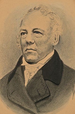
Albion Keith Parris was the 5th Governor of Maine, a United States representative from the District of Maine, Massachusetts, a United States senator from Maine, a United States district judge of the United States District Court for the District of Maine, an associate justice of the Maine Supreme Judicial Court and the 2nd Comptroller of the Currency for the United States Department of the Treasury.
Seminole Tribe of Florida v. Florida, 517 U.S. 44 (1996), was a United States Supreme Court case which held that Article One of the U.S. Constitution did not give the United States Congress the power to abrogate the sovereign immunity of the states that is further protected under the Eleventh Amendment. Such abrogation is permitted where it is necessary to enforce the rights of citizens guaranteed under the Fourteenth Amendment as per Fitzpatrick v. Bitzer. The case also held that the doctrine of Ex parte Young, which allows state officials to be sued in their official capacity for prospective injunctive relief, was inapplicable under these circumstances, because any remedy was limited to the one that Congress had provided.

The secretary of state is an official in the state governments of 47 of the 50 states of the United States, as well as Puerto Rico and other U.S. possessions. In Massachusetts, Pennsylvania, and Virginia, this official is called the secretary of the commonwealth. In states that have one, the secretary of state is the chief clerk of the state and is often the primary custodian of important state records. In the states of Alaska, Hawaii, and Utah, there is no secretary of state; in those states many duties that a secretary of state might normally execute fall within the domain of the lieutenant governor. Like the lieutenant governor, in most states, the secretary of state is in the line of succession to succeed the governor, in most cases immediately behind the lieutenant governor. In three states with no lieutenant governor as well as the U.S. territory of Puerto Rico, the secretary of state is first in the line of succession in the event of a gubernatorial vacancy.

Maine's 2nd congressional district is a congressional district in the U.S. state of Maine. Covering 27,326 square miles (70,770 km2), it comprises nearly 80% of the state's total land area. The district comprises most of the land area north of the Portland and Augusta metropolitan areas. It includes the cities of Lewiston, Bangor, Auburn, and Presque Isle. The district is represented by Democrat Jared Golden, who took office in 2019.

The 2000 United States presidential election in Maine took place on November 7, 2000, and was part of the 2000 United States presidential election. Maine is one of two states in the U.S. that instead of all of the state's four electors of the Electoral College to vote based upon the statewide results of the voters, two of the individual electors vote based on their congressional district because Maine has two congressional districts. The other two electors vote based upon the statewide results.
The West Branch Narraguagus River is a river in Maine. From its source in Maine Township 22, MD, Hancock County, the river runs 25.2 miles (40.6 km) southeast to its confluence with the Narraguagus River in Cherryfield, Washington County.

The 2012 United States presidential election in Maine took place on November 6, 2012, as part of the 2012 United States presidential election in which all 50 states plus the District of Columbia participated. Maine voters chose four electors to represent them in the Electoral College via a popular vote pitting incumbent Democratic President Barack Obama and his running mate, Vice President Joe Biden, against Republican challenger and former Massachusetts Governor Mitt Romney and his running mate, Congressman Paul Ryan. Obama and Biden carried Maine with 56.27% of the popular vote to Romney's and Ryan's 40.98%, thus winning the state's four electoral votes.

The 1992 United States presidential election in Maine took place on November 3, 1992, as part of the 1992 United States presidential election. Voters chose four representatives, or electors to the Electoral College, who voted for president and vice president.

Waysons Corner is an unincorporated community in Anne Arundel County, Maryland, United States, 2.6 miles (4.2 km) east of Upper Marlboro. Waysons Corner is located at the junction of Maryland routes 4 and 408, where the former changes names to Pennsylvania Avenue.

The 1968 United States presidential election in Maine took place on November 5, 1968, as part of the 1968 United States presidential election, which was held throughout all fifty states and D.C. Voters chose four representatives, or electors to the Electoral College, who voted for president and vice president.

The 1852 United States presidential election in Maine took place on November 2, 1852, as part of the 1852 United States presidential election. Voters chose eight representatives, or electors to the Electoral College, who voted for President and Vice President.

The 1936 United States presidential election in Maine was held on November 3, 1936 as part of the 1936 United States presidential election. The state voters chose five electors to the Electoral College, who voted for president and vice president.
Legal forms of gambling in the U.S. state of Maine include parimutuel wagering on horse races, the Maine Lottery, two casinos, and charitable gaming.

