Beals, Maine

Last updated

Beals, Maine
USA Maine relief location map.svg
Red pog.svg
Beals
Usa edcp relief location map.png
Red pog.svg
Beals
Coordinates: 44°30′19″N67°36′14″W / 44.50528°N 67.60389°W / 44.50528; -67.60389
Country United States
State Maine
County Washington
Area
[1]
  Total
48.33 sq mi (125.17 km2)
  Land5.62 sq mi (14.56 km2)
  Water42.71 sq mi (110.62 km2)
Elevation
30 ft (9 m)
Population
 (2020)
  Total
443
  Density79/sq mi (30.4/km2)
Time zone UTC-5 (Eastern (EST))
  Summer (DST) UTC-4 (EDT)
ZIP code
04611
Area code 207
FIPS code 23-03670
GNIS feature ID0582344

Beals is a town in Washington County, Maine, United States, located on an island opposite Jonesport. The town was named after Manwarren Beal, an early settler. [2] The population was 443 at the 2020 census. [3]

Contents

Geography

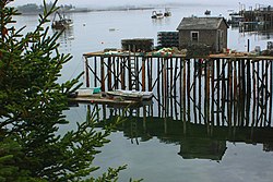
Pier at low tide A312, Beals Island, Maine, USA, 2009.JPG
Pier at low tide

According to the United States Census Bureau, the town has a total area of 48.33 square miles (125.17 km2), of which 5.62 square miles (14.56 km2) is land and 42.71 square miles (110.62 km2) is water. [1] The main settlement of Beals is located on Beals Island, which is connected by a bridge across Moosabec Reach to Jonesport on the mainland. Beals Island is connected to the southeast by a short bridge to Great Wass Island, also within the town of Beals and which comprises the Great Wass Island Preserve.

Demographics

Historical population
CensusPop.Note
1830 55
1930 524
1940 513−2.1%
1950 59015.0%
1960 6408.5%
1970 6633.6%
1980 6954.8%
1990 667−4.0%
2000 618−7.3%
2010 508−17.8%
2020 443−12.8%
U.S. Decennial Census [4]

2010 census

As of the census [5] of 2010, there were 508 people, 228 households, and 147 families living in the town. The population density was 90.4 inhabitants per square mile (34.9/km2). There were 361 housing units at an average density of 64.2 per square mile (24.8/km2). The racial makeup of the town was 97.8% White, 0.8% African American, 0.8% Native American, and 0.6% from two or more races.

There were 228 households, of which 23.2% had children under the age of 18 living with them, 54.4% were married couples living together, 6.6% had a female householder with no husband present, 3.5% had a male householder with no wife present, and 35.5% were non-families. 28.1% of all households were made up of individuals, and 12.3% had someone living alone who was 65 years of age or older. The average household size was 2.23 and the average family size was 2.69.

The median age in the town was 48.1 years. 16.9% of residents were under the age of 18; 9.2% were between the ages of 18 and 24; 18.8% were from 25 to 44; 32.6% were from 45 to 64; and 22.2% were 65 years of age or older. The gender makeup of the town was 51.2% male and 48.8% female.

2000 census

As of the census [6] of 2000, there were 618 people, 237 households, and 188 families living in the town. The population density was 108.7 inhabitants per square mile (42.0/km2). There were 370 housing units at an average density of 65.1 per square mile (25.1/km2). The racial makeup of the town was 97.57% White, 1.29% African American, 0.65% Native American, 0.16% Asian, and 0.32% from two or more races. Hispanic or Latino of any race were 2.10% of the population.

There were 237 households, out of which 34.6% had children under the age of 18 living with them, 69.6% were married couples living together, 6.3% had a female householder with no husband present, and 20.3% were non-families. 16.0% of all households were made up of individuals, and 9.3% had someone living alone who was 65 years of age or older. The average household size was 2.55 and the average family size was 2.85.

In the town, the population was spread out, with 24.9% under the age of 18, 5.8% from 18 to 24, 27.5% from 25 to 44, 24.3% from 45 to 64, and 17.5% who were 65 years of age or older. The median age was 40 years. For every 100 females, there were 106.7 males. For every 100 females age 18 and over, there were 104.4 males.

The median income for a household in the town was $29,375, and the median income for a family was $31,458. Males had a median income of $28,125 versus $24,167 for females. The per capita income for the town was $13,133. About 10.6% of families and 16.7% of the population were below the poverty line, including 20.8% of those under age 18 and 11.9% of those age 65 or over.

Related Research Articles

<span class="mw-page-title-main">Washington County, Maine</span> County in Maine, United States

Washington County is a county located in the U.S. state of Maine. As of the 2020 census, its population was 31,095, making it the third-least populous county in Maine. Its county seat is Machias. The county was established on June 25, 1789. It borders the Canadian province of New Brunswick. It is sometimes referred to as "Sunrise County" because it includes the easternmost point in the 48 contiguous United States. Claims have been made that Washington County is where the sun first rises on the 48 contiguous states. Many small seaside communities have small-scale fishing-based economies. Tourism is also important along the county's shoreline, but it is not as important as elsewhere in the state. The blueberry crop plays a major role in the county's economy.

Ridgeway is a census-designated place (CDP) in Kenai Peninsula Borough, Alaska, United States. At the 2020 census the population was 2,136, up from 2,022 in 2010.

<span class="mw-page-title-main">Westbrook, Connecticut</span> Town in Connecticut, United States

Westbrook is a town in Middlesex County, Connecticut, United States. The town is part of the Lower Connecticut River Valley Planning Region. The population was 6,769 at the 2020 census. The town center is classified by the U.S. Census Bureau as a census-designated place (CDP).

<span class="mw-page-title-main">Paragon, Indiana</span> Town in Indiana, United States

Paragon is a town in Ray Township, Morgan County, in the U.S. state of Indiana. The population was 556 at the 2020 census, down from 659 in 2010.

<span class="mw-page-title-main">Dolliver, Iowa</span> City in Iowa, United States

Dolliver is a city in Emmet County, Iowa, United States. The population was 65 at the 2020 census.

<span class="mw-page-title-main">Hersey, Maine</span> Town in the state of Maine, United States

Hersey is a town in Aroostook County, Maine, United States. The population was 73 at the 2020 census.

<span class="mw-page-title-main">Island Falls, Maine</span> Town in the state of Maine, United States

Island Falls is a town in Aroostook County, Maine, United States. The population was 758 at the 2020 census. The primary village of Island Falls in the town is situated at a falls in the West Branch Mattawamkeag River.

Greenwood is a town in Oxford County, Maine, United States. The population was 774 at the 2020 census. The town was named for surveyor Alexander Greenwood. The village of Locke Mills, on State Route 26 in the northern part of Greenwood, is the town's urban center and largest settlement.

Lowell is a town in Penobscot County, Maine, United States. The population was 368 at the 2020 census.

<span class="mw-page-title-main">Burnham, Maine</span> Town in the state of Maine, United States

Burnham is a town in Waldo County, Maine, United States. The population was 1,096 at the 2020 census.

<span class="mw-page-title-main">Monroe, Maine</span> Town in the state of Maine, United States

Monroe is a town in Waldo County, Maine, United States named for President James Monroe. The population was 931 at the 2020 census.

<span class="mw-page-title-main">Addison, Maine</span> Town in the state of Maine, United States

Addison is a town in Washington County, Maine, United States. The town was named after English author Joseph Addison. The population was 1,148 as of the 2020 census.

<span class="mw-page-title-main">Jonesport, Maine</span> Town in Maine, United States

Jonesport is a town in Washington County, Maine, United States. The population was 1,245 at the 2020 census. Jonesport is a fishing and lobstering town. It contains the villages or hamlets of Jonesport, Mason Bay, Monsapec, and West Jonesport.

<span class="mw-page-title-main">Amherst Center, Massachusetts</span> Census-designated place in Massachusetts, United States

Amherst Center is a census-designated place (CDP) in the City of Amherst in Hampshire County, Massachusetts, United States. The CDP covers the primary village in town. The population was 19,065 at the 2010 census, out of a total city population of 37,819. It is part of the Springfield, Massachusetts Metropolitan Statistical Area.

<span class="mw-page-title-main">Hoyt Lakes, Minnesota</span> City in Minnesota, United States

Hoyt Lakes is a city in Saint Louis County, Minnesota. The population was 2,020 at the time of the 2020 census.

<span class="mw-page-title-main">Junior, West Virginia</span> Town in West Virginia, United States

Junior is a town in Barbour County, West Virginia, United States, situated along the Tygart Valley River. The population was 384 at the 2020 census.

<span class="mw-page-title-main">Leon, West Virginia</span> Town in West Virginia, United States

Leon is a town in Mason County, West Virginia, United States, situated along the Kanawha River. The population was 137 at the 2020 census. It is part of the Point Pleasant, WV–OH Micropolitan Statistical Area.

<span class="mw-page-title-main">Davy, West Virginia</span> Town in West Virginia, United States

Davy is a town in McDowell County, West Virginia, United States. The population was 209 at the 2020 census, down from 420 at the 2010 census. Founded in 1873, the town was originally called Hallsville but the name would change to Davy by 1901. Davy was officially incorporated in 1948. It is a mostly residential community in a coal mining district along the main line of the Norfolk Southern Railway.

<span class="mw-page-title-main">Newburg, West Virginia</span> Town in West Virginia, United States

Newburg is a town in western Preston County, West Virginia, United States. The population was 275 at the 2020 census. It is part of the Morgantown metropolitan area.

<span class="mw-page-title-main">Hambleton, West Virginia</span> Town in West Virginia, United States

Hambleton is a town in Tucker County, West Virginia, United States. The population was 216 at the 2020 census. Hambleton was established in 1889, but not incorporated until 1905. It was named by then United States Senator Stephen B. Elkins in honor of a stockholder by this name in the West Virginia Central Railroad Company. The town was previously known as Hulings.

References

  1. 1 2 "US Gazetteer files 2010". United States Census Bureau . Retrieved December 16, 2012.
  2. "Remember the day when..." (PDF). moosabec.org. Beals Historical Society. 2007. Retrieved October 30, 2018.
  3. "Census - Geography Profile: Beals town, Washington County, Maine". United States Census Bureau . Retrieved February 26, 2022.
  4. "Census of Population and Housing". Census.gov. Retrieved June 4, 2015.
  5. "U.S. Census website". United States Census Bureau . Retrieved December 16, 2012.
  6. "U.S. Census website". United States Census Bureau . Retrieved January 31, 2008.

44°31′11″N67°36′54″W / 44.51972°N 67.61500°W / 44.51972; -67.61500