Birampur Upazila

Last updated • 3 min readFrom Wikipedia, The Free Encyclopedia
Birampur
বিরামপুর
Birampur New Station.jpg
Birampur Railway Station
"Dhaka Morr" The main point of Birampur Upazilla.
Birampur in Rangpur division (Bangladesh).svg
Coordinates: 25°23′29″N88°59′32″E / 25.391479°N 88.992111°E / 25.391479; 88.992111
Country Flag of Bangladesh.svg  Bangladesh
Division Rangpur
District Dinajpur
Government
  Chief Executive Officer Nujhat Tasnim Ayon
Area
  Total
212.88 km2 (82.19 sq mi)
Population
 (2022) [1]
  Total
184,144
  Density870/km2 (2,200/sq mi)
Time zone UTC+6 (BST)
Postal code
5266 [2]
Website birampur.dinajpur.gov.bd

Birampur (Bengali : বিরামপুর) is an upazilla of Dinajpur District [3] in the Division of Rangpur, Bangladesh. Birampur is an important city near India Border. This upazila is 256 km away from Capital Dhaka and nearly 56 km away from Dinajpur City. In spite of being far from Capital this north Bengal city is flourishing economically and culturally. A branch of the Jamuna River flows through Birampur Upazila.

Contents

Geography

Birampur has 42,140 households and total area 212.88 km2. It is an upazila of Dinajpur.

Sohed Minar of Birampur Sohed Minar of Birampur.JPG
Sohed Minar of Birampur

Birampur Upazilla is bounded by Fulbari and Nawabganj Upazillas on the north, Nawabganj and Hakimpur Upazillas on the east, Hakimpur Upazila and Hili CD Block in Dakshin Dinajpur district, West Bengal, India, on the south and Kumarganj CD Block in Dakshin Dinajpur district, West Bengal, India, on the west. [3] [4] [5]

Rivers and lakes

Demographics

Religions in Birampur Upazila (2022) [6]
ReligionPercent
Islam
90.01%
Hinduism
6.76%
Christianity
2.95%
Ethnic religion
0.27%

According to the 2011 Census of Bangladesh, Birampur Upazila had 42,140 households and a population of 170,806. 34,329 (20.10%) were under 10 years of age. Birampur had a literacy rate (age 7 and over) of 51.64%, compared to the national average of 51.8%, and a sex ratio of 977 females per 1000 males. 47,539 (27.83%) lived in urban areas. [7] Ethnic population was 7,855 (4.60%), of which Santal were 5,605. [8]

As of the 1991 Bangladesh census, Birampur has a population of 134778. Males constitute 51.12% of the population, and females 48.88%. This Upazilla's eighteen up population is 68878. Literacy rate and educational institutions Average literacy 46.9%; male 51.7%, female 42%. [9] In 2001, The Population of Birampur was 150620; male 77517, female 73103; Muslim 134654, Hindu 8142, Christian 3689, Buddhist 40 and others 4095. The Density of Forestry in Birampur is approximately 18.5%.

Administration

UNO : Nuzhat Tasneem Awon. [10]

Birampur Thana was formed on 17 June 1981, and it was turned into an upazila in 1983. [3]

Birampur Upazilla is divided into Birampur Municipality and seven union parishads: Benail, Dior, Jotbani, Katla, Khanpur, Mukundapur, and Pali Prayagpur. The union parishads are subdivided into 171 mauzas and 169 villages. [7]

Birampur Municipality was formed in 1995. It was subdivided into 9 wards and 26 mahallas. [7]

Birampur Upzilla Porishad.jpg

Md. Khairul Alam Raju is now the Upazila Chairman in the Upazila Chairman election. Election held on 18 March 2019. And so on Md. Liakat Ali Sarker Tutul is working as Mayor of Birampur Pouroshova.

Unions of Birampur
SerialName of UnionChairman
01DiorAbul Hossain
02BenailNazir Hossen
03JotbaniEyakub
04KatlaHafizur Rahman
05KhanpurShahidul Islam
06MukundapurAbdur Razzaq
07Pali PrayagpurRahmat Ali

Economy

The main sources of income Agriculture 68.37%, non-agricultural labourer 2.92%, industry 0.86%, commerce 13.08%, transport and communication 2.64%, service 5.1%, construction 0.67%, religious service 0.16%, rent and remittance 0.17% and others 6.03%. Ownership of agricultural land landowner 57.24%, landless 42.76%; agricultural landowner: urban 44.34% and rural 61.34%. The main crops of Birampur are paddy, wheat, corn, jute, potato, vegetables. Mustard, sugarcane and sesame are near extinction. The main fruits are mango, banana, jackfruit, and blackberry. There are 17 fisheries, dairies and poultries.

Contributions

Liberation War 1971

History of the War of Liberation On 20 April 1971, the Pak army killed a few hundred innocent people at Charar Hat of Birampur. Seven Pakistani soldiers and 16 freedom fighters were killed in a direct encounter between the freedom fighters and the Pakistan army at Ketra Hat. On 4 December the general public of the upazila attacked a military vehicle of the Pak army at Beparitola and killed a number of Pak soldiers.

Education

The upazila has 5 colleges, 1 textile institute, 38 secondary schools, 162 primary schools, 28 madrasas. There is also a digital school in the upazila named Birampur ICT School.

Educational institutions

See also

Related Research Articles

<span class="mw-page-title-main">Dinajpur District, Bangladesh</span> District of Rangpur Division in Bangladesh

Dinajpur District is a district in the Rangpur Division of northern Bangladesh. Dinajpur is the largest district among all sixteen northern districts of Bangladesh.

<span class="mw-page-title-main">Golapganj Upazila</span> Upazila of Sylhet, Bangladesh

Golapganj Upazila, previously known as Gulabganj, is an upazila of Sylhet District in Sylhet Division, Bangladesh.

<span class="mw-page-title-main">Daulatpur Upazila, Manikganj</span> Upazila in Dhaka, Bangladesh

Daulatpur is an upazila of Manikganj District in the Division of Dhaka, Bangladesh.

<span class="mw-page-title-main">Nandail Upazila</span> Upazila in Mymensingh, Bangladesh

Nandail is an upazila of Mymensingh District in the division of Mymensingh, Bangladesh, and roughly 46 kilometers from Mymensingh City.

<span class="mw-page-title-main">Bochaganj Upazila</span> Upazila in Rangpur, Bangladesh

Bochaganj is an upazila of Dinajpur District in the division of Rangpur, Bangladesh. Setabganj town is the headquarter of Bochaganj Upazila unlike many other Upazila and district of Bangladesh. Setabganj town is the closest in location to district headquarters among other Upazila headquarters of Dinajpur.

<span class="mw-page-title-main">Chirirbandar Upazila</span> Upazila in Rangpur, Bangladesh

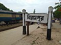
Chirirbandar is an upazila of Dinajpur District in the Division of Rangpur, Bangladesh.

<span class="mw-page-title-main">Fulbari Upazila</span> Upazila in Rangpur, Bangladesh

Fulbari is an upazila of Dinajpur District in the Division of Rangpur Division, Bangladesh.

<span class="mw-page-title-main">Ghoraghat Upazila</span> Upazila in Dinajpur District, Bangladesh

Ghoraghat, is an upazila of Dinajpur District in the Division of Rangpur, Bangladesh.

<span class="mw-page-title-main">Hakimpur Upazila</span> Upazila in Rangpur, Bangladesh

Hakimpur is an upazila of Dinajpur District in the Division of Rangpur, Bangladesh.

<span class="mw-page-title-main">Dinajpur Sadar Upazila</span> Upazila in Rangpur, Bangladesh

Dinajpur Sadar is an upazila of Dinajpur District in the Division of Rangpur, Bangladesh.

<span class="mw-page-title-main">Nawabganj Upazila, Dinajpur</span> Upazila in Rangpur, Bangladesh

Nawabganj is an upazila of Dinajpur District in the Division of Rangpur, Bangladesh.

<span class="mw-page-title-main">Joypurhat Sadar Upazila</span> Upazila in Rajshahi, Bangladesh

Joypurhat Sadar is an upazila of Joypurhat District in the Division of Rajshahi, Bangladesh.

<span class="mw-page-title-main">Panchbibi Upazila</span> Upazila in Rajshahi, Bangladesh

Panchbibi is an upazila of Joypurhat District in the Division of Rajshahi, Bangladesh.

<span class="mw-page-title-main">Dhamoirhat Upazila</span> Upazila in Rajshahi, Bangladesh

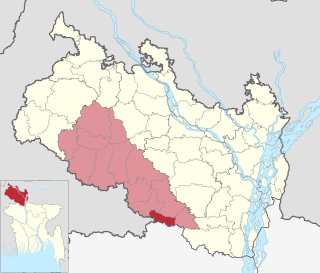
Dhamoirhat is an upazila of Naogaon District in the Division of Rajshahi, Bangladesh. The main river of the Dhamoirhat Upazila is the Atrai.

<span class="mw-page-title-main">Patnitala Upazila</span> Upazila in Rajshahi, Bangladesh

Patnitala is an Upazila of Naogaon District in the Division of Rajshahi, Bangladesh.

<span class="mw-page-title-main">Sapahar Upazila</span> Upazila in Rajshahi, Bangladesh

Sapahar is an upazila of Naogaon District in the Division of Rajshahi, Bangladesh.

<span class="mw-page-title-main">Baliadangi Upazila</span> Upazila in Rangpur, Bangladesh

Baliadangi is an Upazila of Thakurgaon District in the Division of Rangpur, Bangladesh.

<span class="mw-page-title-main">Pirganj Upazila, Thakurgaon</span> Upazila in Thakurgaon District, Bangladesh

Pirganj is an Upazila of Thakurgaon District in the Division of Rangpur, Bangladesh.

<span class="mw-page-title-main">Ranisankail Upazila</span> Upazila in Rangpur, Bangladesh

Ranisankail is an Upazila of Thakurgaon District in the Division of Rangpur, Bangladesh.

<span class="mw-page-title-main">Hili (community development block)</span> Community development block in West Bengal, India

Hili is a community development block that forms an administrative division in Balurghat subdivision of Dakshin Dinajpur district in the Indian state of West Bengal.

References

  1. National Report (PDF). Population and Housing Census 2022. Vol. 1. Dhaka: Bangladesh Bureau of Statistics. November 2023. p. 402. ISBN   978-9844752016.
  2. "Bangladesh Postal Code". Dhaka: Bangladesh Postal Department under the Department of Posts and Telecommunications of the Ministry of Posts, Telecommunications and Information Technology of the People's Republic of Bangladesh. 21 October 2024.
  3. 1 2 3 Shamsuzzaman (2012). "Birampur Upazila". In Sirajul Islam and Ahmed A. Jamal (ed.). Banglapedia: National Encyclopedia of Bangladesh (Second ed.). Asiatic Society of Bangladesh.
  4. "District Census Handbook 2011 Dakshin Dinajpur" (PDF). Map of Dakshin Dinajpur showing CD Blocks on the fourth page. Directorate of Census Operations. Retrieved 8 December 2018.
  5. "District Human Development Report". Uttar Dinajpur. Page 14: Map showing locational setting of Uttar Dinajpur district (includes Dakshin Dinajpur district). Department of Planning, Statistics and Programme Implementation, Government of West Bengal. Archived from the original on 19 January 2018. Retrieved 8 December 2018.
  6. Population and Housing Census 2022 - District Report: Dinajpur (PDF). District Series. Dhaka: Bangladesh Bureau of Statistics. June 2024. ISBN   978-984-475-270-2.
  7. 1 2 3 "Bangladesh Population and Housing Census 2011 Zila Report – Dinajpur" (PDF). bbs.gov.bd. Bangladesh Bureau of Statistics.
  8. "Community Tables: Dinajpur district" (PDF). bbs.gov.bd. Bangladesh Bureau of Statistics. 2011.
  9. "Population Census Wing, BBS". Archived from the original on 2005-03-27. Retrieved November 10, 2006.
  10. উপজেলা নির্বাহী অফিসার. 2024-08-27. Archived from the original on 2024-08-27.