
Zinder, formerly also spelled Sinder, is the third largest city in Niger, with a population of 235,605 as by the 2012 census. It is situated 861 km (535 mi) east of the capital Niamey and 240 km (150 mi) north of the Nigerian city of Kano.
Birni-N'Konni is a town in the Tahoua Region of Niger, lying immediately north of the border of Nigeria and west of seasonal Maggia River. It is an important market town and transport hub and as of the 2012 census had a population of 63,169. The town is the historic centre of the small pre-colonial Hausa state of Konni. The name comes from the Hausa for "Walled Town of Konni", and many Hausa towns designate the old citadel neighbourhood the "Birni".

Tahoua is one of eight Regions of Niger. The capital of the region is the commune of Tahoua. The region covers 106,677 km².
Birni N'Gaouré is a town located in the Dosso Region in southwest Niger. A town of over ten thousand, it is the departmental seat of Boboye Department, and is the main town of the fertile farming region in which it is located. "Birni", in the name of the town, derives from the Hausa language word for a walled city.
Karimama is a town, arrondissement and commune in the Alibori Department of northeastern Benin. The commune covers an area of 6102 square kilometers and as of 2013 had a population of 66,675 people. The town lies on the border with Niger.
Bouza is a town in southwestern Niger. A town of eight thousand, it is the administrative center of Bouza Department, part of Tahoua Region.
Dabnou is a town in southwestern Niger. It is near the city of Tahoua. It is located in the Department of Illela, in Tahoua region, municipality of Badaguichiri. It has two districts, Angoua Gabas and Angoua Yamma . The head of Angouas Gabas is Elhadji Gado Nahantchi. The head of Angouas Yamma is Mourtala Aboubacar Nabirni The population is about 13,000 people. Almost all them are Hausa people. There are some Fulani in the town. It has four primary schools, one college school and a health center. The population practice agriculture, livestock and trade. A market takes place every Saturday. The town is crossed by the highway RN2, which connects Birni N'Konni in Tahoua.
The following outline is provided as an overview of and topical guide to Niger:

Niger is divided into seven regions, each of which is named after its capital. Additionally, the national capital, Niamey, comprises a capital district.

Boboye is a department of the Dosso Region in Niger. Its capital lies at the city of Birni N'Gaouré. As of 2011, the department had a total population of 372,904 people.

Bouza is a department of the Tahoua Region in Niger. Its capital lies at the city of Bouza, and also includes the town of Déoulé. As of 2011, the department had a total population of 386,093 people.
Konni is a traditional Hausa state in what is today south central Maradi Region Niger and north Sokoto State Nigeria. It continues to exist as a ceremonial polity centered on the Nigerien city of Birni-N'Konni.

Niger is governed through a four layer, semi-decentralised series of administrative divisions. Begun 1992, and finally approved with the formation of the Fifth Republic of Niger on 18 July 1999, Niger has been enacting a plan for decentralisation of some state powers to local bodies. Prior to the 1999-2006 project, Niger's subdivisions were administered via direct appointment from the central government in Niamey. Beginning with Niger's first municipal elections of 2 February 1999, the nation started electing local officials for the first time. Citizens now elect local committee representatives in each commune, chosen by subdivisions of the commune: "quarters" in towns and "villages" in rural areas, with additional groupings for traditional polities and nomadic populations. These officials choose mayors, and from them are drawn representatives to the department level. The departmental council, prefect, and representatives to the regional level are chosen here using the same procedure. The system is repeated a regional level, with a regional prefect, council, and representatives to the High Council of Territorial Collectives. The HCCT has only advisory powers, but its members have some financial, planning, educational and environmental powers. The central government oversees this process through the office of the Minister of State for the Interior, Public Safety and Decentralization.
The 1974 Nigerien coup d'état was a largely bloodless military insurrection which overthrew the first postcolonial government of Niger. The government that followed, while plagued by coup attempts of its own, survived until 1991.
The Maouri people are an ethnic group in western Africa. They are one of the major ethnic groups of Niger, and are concentrated around the Dallol Maouri of the Niger River, extending from Matankari, near Niamey, to Gaya. They are a subgroup of the Hausa people, and speak both the Hausa language and the Djerma language. When using the Zarma language, they are known as the Arawa people.
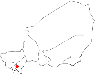
Sabonga is a town of about 10,000 people in Birni-N'Konni Department, Tahoua Region, Niger.

The Niger–Nigeria border is 1,608 kilometres in length and runs from the tripoint with Benin in the west to the tripoint with Chad in the east.
This article lists events from the year 2020 in Niger.
