Blandas

Last updated

Blandas
Blandas Rigalderie 1.jpg
Part of the Rigalderie stone circle in Blandas
Blason de la ville de Blandas (30).svg
Location of Blandas
Blandas
France location map-Regions and departements-2016.svg
Red pog.svg
Blandas
Languedoc-Roussillon-Midi-Pyrenees region location map.svg
Red pog.svg
Blandas
Coordinates: 43°54′49″N3°30′49″E / 43.9136°N 3.5136°E / 43.9136; 3.5136
Country France
Region Occitania
Department Gard
Arrondissement Le Vigan
Canton Le Vigan
Intercommunality Pays Viganais
Government
  Mayor (20202026) Marc Weller [1]
Area
1
37.46 km2 (14.46 sq mi)
Population
 (Jan. 2020) [2]
127
  Density3.4/km2 (8.8/sq mi)
Time zone UTC+01:00 (CET)
  Summer (DST) UTC+02:00 (CEST)
INSEE/Postal code
30040 /30770
Elevation280–953 m (919–3,127 ft)
(avg. 650 m or 2,130 ft)
1 French Land Register data, which excludes lakes, ponds, glaciers > 1 km2 (0.386 sq mi or 247 acres) and river estuaries.

Blandas is a commune in the Gard department in southern France. It is known for its proximity to the Cirque de Navacelles and the town encompasses one of the principal overlooks on the Cirque. It is also known for its exceptional megalithic sites. It is included in the UNESCO world heritage site "The Causses and the Cévennes, Mediterranean agro-pastoral Cultural Landscape" [3] [4]

Contents

Population

Historical population
YearPop.±%
1881528    
1891506−4.2%
1901420−17.0%
1911355−15.5%
1921268−24.5%
1931268+0.0%
1936227−15.3%
1954196−13.7%
1962172−12.2%
1968141−18.0%
1975115−18.4%
1982116+0.9%
1990112−3.4%
1999106−5.4%
2008128+20.8%

History

Prehistoric Finds

La grotte des Pins

In May 1967 a team of speleologists attempted to enlarge a natural opening exposed by erosion. Their work exposed a large hidden room 5m high and on the floor of the room they found fragments of ceramics. Further exploration uncovered tools, objects, and much scattered charcoal, up to 60 cm thick in places possibly from prehistoric torches. Theories at the time suggested that the cave served as a cellar or storage, rather than a habitation, since a lack of air circulation made hearth fires difficult. [5]

Baume du Roc du Midi

In 1979 at Baume du Roc du Midi, a cave which opens out from the cliff on the edge of the causse de Blandas at a lookout with a view over the Cirque de Navacelles, archeologists discovered a walled part of the cave, closed since the Middle Ages, but inhabited continuously from prehistory into protohistoric times. Inside the walled portion, many objects including two copper daggers with serrated blades, a bronze axe, a riveted bronze dagger, bronze sconces, spear-tips, and many other Bronze Age objects [6]

La Baumelle

A discovery was made in 2009 [7] by speleologists in a prehistoric cave which had been blocked for over 5000 years. On August 10, 2009, speleologists, along with Laurent Bruxelles and Philippe Galant, from Institut national de Recherches archéologiques préventives, began a 10-day exploration of the find. The entrance was blocked by a menhir or stele. This sandstone monolith with engraved surface had been moved from a deposit found at Montdardier 5–6 km from the cave. Prehistoric remains were discovered: skulls, some covered in calcite, pieces of water-collecting vessels, ceramic shards, and a furnished hallway. [8]

Megaliths

see also Mégalithes du causse de Blandas (fr)

MonumentTownNoteProtectionCoordinatesPhoto
Cromlech de Lacam de Peyrarines BlandasA prehistoric cromlech of 120m in diameter, including 50 standing stones of up to 1.8m high with a standing center menhir. Considered by many to be among the most impressive in Europe. [9] [10] 43°55′34″N3°31′50″E / 43.9261°N 3.5306°E / 43.9261; 3.5306 (Cromlech de Lacam de Peyrarines) Peyrarines 1.jpg
Cromlech de Lacam de la Rigalderie BlandasA cromlech of approximately 90m in diameter with 36 stones, 20 of which are still upright, but lacking a central pillar. One menhir stands 2.5m high [11] 43°55′38″N3°29′29″E / 43.9272°N 3.4914°E / 43.9272; 3.4914 (Cromlech de Lacam de la Rigalderie) Blandas Rigalderie 1.jpg
Cromlech de Lacam de Rogues Blandas 43°53′39″N3°33′50″E / 43.8942°N 3.5638°E / 43.8942; 3.5638 (Cromlech de Lacam de Rogues)
Dolmen d'Arques Blandas 43°56′16″N3°30′12″E / 43.9377°N 3.5032°E / 43.9377; 3.5032 (Dolmen d'Arques)
Dolmen de Barral Blandas 43°54′46″N3°33′15″E / 43.9127°N 3.5541°E / 43.9127; 3.5541 (Dolmen de Barral)
Dolmen de la Borie d'Arre Blandas 43°53′37″N3°32′12″E / 43.8936°N 3.5367°E / 43.8936; 3.5367 (Dolmen de la Borie d'Arre)
Dolmen de Planas Blandas 43°55′42″N3°32′12″E / 43.9282°N 3.5366°E / 43.9282; 3.5366 (Dolmen de Planas)
Dolmen de Regos Blandas 43°55′15″N3°32′34″E / 43.9207°N 3.5427°E / 43.9207; 3.5427 (Dolmen de Regos)
Dolmen du Château d'Assas Blandas 43°54′41″N3°32′15″E / 43.9115°N 3.5374°E / 43.9115; 3.5374 (Dolmen du Château d'Assas)
Menhir d'Avernat Blandas 43°56′09″N3°29′36″E / 43.9357°N 3.4934°E / 43.9357; 3.4934 (Menhirs d'Avernat)
Menhir des Combes Blandas 43°56′09″N3°29′45″E / 43.9359°N 3.4958°E / 43.9359; 3.4958 (Menhir des Combes)
Menhir de Planas Blandasother name Menhir du Serre de la Gleisa 43°55′36″N3°32′21″E / 43.9266°N 3.5391°E / 43.9266; 3.5391 (Menhir de Planas)
Menhir du Sotch des Genièvres Blandas 43°55′34″N3°31′17″E / 43.9262°N 3.5215°E / 43.9262; 3.5215 (Menhir du Sotch des Genièvres)
Menhirs de Landre Blandas3 menhirs 43°56′11″N3°30′58″E / 43.9365°N 3.5162°E / 43.9365; 3.5162 (Menhir de Landre)
Menhirs du Travers des Noyers Blandas2 menhirs 43°54′02″N3°31′15″E / 43.9006°N 3.5207°E / 43.9006; 3.5207 (Menhir du Travers des Noyers)
Gard department relief location map.jpg
X solid black 17.gif
1
X solid black 17.gif
2
X solid black 17.gif
3
X solid black 17.gif
4
X solid black 17.gif
5
X solid black 17.gif
6
X solid black 17.gif
7
X solid black 17.gif
8
X solid black 17.gif
9
X solid black 17.gif
10
X solid black 17.gif
11
X solid black 17.gif
12
X solid black 17.gif
13
X solid black 17.gif
14
X solid black 17.gif
15
map of Megaliths in Blandas (Gard), France

See also

Related Research Articles

<span class="mw-page-title-main">Hérault</span> Department in Occitanie, France

Hérault is a department of the region of Occitania, Southern France. Named after the Hérault River, its prefecture is Montpellier. It had a population of 1,175,623 in 2019.

<span class="mw-page-title-main">Massif Central</span> A highland region in the middle of Southern France

The Massif Central is a highland region in south-central France, consisting of mountains and plateaus. It covers about 15% of mainland France.

<span class="mw-page-title-main">Cévennes</span> Mountain range in France

The Cévennes is a cultural region and range of mountains in south-central France, on the south-east edge of the Massif Central. It covers parts of the départements of Ardèche, Gard, Hérault and Lozère. Rich in geographical, natural, and cultural significance, portions of the region are protected within the Cévennes National Park, the Cévennes Biosphere Reserve (UNESCO), as well as a UNESCO World Heritage Site: Causses and the Cévennes, Mediterranean agro-pastoral Cultural Landscape. The area has been inhabited since 400,000 BCE and has numerous megaliths which were erected beginning around 2500 BCE. As an agriculturally-rich area, but not a suitable location for cities, the Cévennes developed a wide diversity of pastoral systems, including transhumance. The irrigation and road networks put in place in the early Middle Ages for these pastoral systems are still in use today.

<span class="mw-page-title-main">Cévennes National Park</span> French national park in Lozère, Gard, Ardèche and Aveyron

Cévennes National Park is a French national park located in Southern France, in the mountainous area of Cévennes.

<span class="mw-page-title-main">Les Eyzies-de-Tayac-Sireuil</span> Part of Les Eyzies in Nouvelle-Aquitaine, France

Les Eyzies-de-Tayac-Sireuil is a former commune in the Dordogne department in Nouvelle-Aquitaine in southwestern France. On 1 January 2019, it was merged into the new commune Les Eyzies.

<span class="mw-page-title-main">Causses</span> UNESCO World Heritage Site in Massif Central, France

The Causses are a group of limestone plateaux in the Massif Central. They are bordered to the north-west by the Limousin and the Périgord uplands, and to the east by the Aubrac and the Cévennes. Large rivers gorges cut through the plateaux, such as the Tarn, Dourbie, Jonte, Lot the Vis (river) and Aveyron. Causse is an Occitan word meaning "limestone plateau" coming from the latin word calx meaning limestone or chalk.

<span class="mw-page-title-main">Cirque de Navacelles</span>

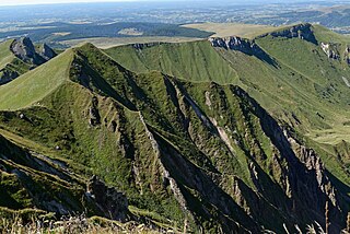
The Cirque de Navacelles is large erosional landform, an incised meander, located towards the southern edge of the Massif Central mountain range in France. It is located near Saint-Maurice-Navacelles and Blandas between the Hérault department and the Gard department.

<span class="mw-page-title-main">Édouard-Alfred Martel</span> Late 19th- to early 20th-century cave explorer

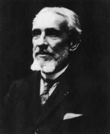
Édouard-Alfred Martel, the 'father of modern speleology', was a world pioneer of cave exploration, study, and documentation. Martel explored thousands of caves in his native France and many other countries, popularised the pursuit of cave exploration, introduced the concept of speleology as a distinct area of scientific study, maintained an extensive archive, and in 1895 founded Société de Spéléologie, the first organisation devoted to cave science in the world.

<span class="mw-page-title-main">Cave of the Trois-Frères</span> Cave in southwestern France famous for its cave paintings

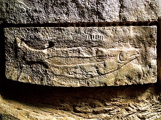
The Cave of the Trois-Frères is a cave in southwestern France famous for its cave paintings. It is located in Montesquieu-Avantès, in the Ariège département. The cave is named for three brothers, Max, Jacques, and Louis Begouën, who, along with their father Comte Henri Begouën, discovered it in 1914. The drawings of the cave were made famous in the publications of the Abbé Henri Breuil. The cave art appears to date to approximately 13,000 BC.

<span class="mw-page-title-main">Prehistory of France</span> Paleolithic to Iron Age prehistory of France

Prehistoric France is the period in the human occupation of the geographical area covered by present-day France which extended through prehistory and ended in the Iron Age with the Roman conquest, when the territory enters the domain of written history.

<span class="mw-page-title-main">Saint-Martin-d'Ardèche</span> Commune in Auvergne-Rhône-Alpes, France

Saint-Martin-d'Ardèche is a commune in the department of Ardèche in Southern France.

<span class="mw-page-title-main">Roc-aux-Sorciers</span> Cave and archaeological site with prehistoric art in France

Roc-aux-Sorciers is an Upper Paleolithic rock shelter site dating to the mid-Magdalenian cultural stage, ca 14,000 yBP, made famous by its relief wall carvings. The site is in the French commune of Angles-sur-l'Anglin, in Vienne. The name 'Sorcerers' Rock', with its suggestions of pagan rendez-vous, was applied to the site long before the wall-carvings were discovered.

<span class="mw-page-title-main">Vis (river)</span> River in southern France

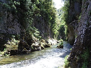
The Vis is a 57.8-kilometre-long (35.9 mi) river in south-central France, in the Occitanie administrative region. It is a right tributary of the Hérault. Its source is in the Cévennes, near the village of Alzon. It flows between the Causse du Larzac and the Causse de Blandas into the Hérault and Gard departments. The Vis flows into the Hérault near Ganges.

<span class="mw-page-title-main">Prehistoric Sites and Decorated Caves of the Vézère Valley</span> UNESCO World Heritage Site of prehistoric decorated caves in the Vézère Valley, France

The Prehistoric Sites and Decorated Caves of the Vézère Valley is a UNESCO World Heritage Site in France since 1979. It specifically lists 15 prehistoric sites in the Vézère valley in the Dordogne department, mostly in and around Les Eyzies-de-Tayac-Sireuil, which has been called the "Capital of Prehistory". This valley is exceptionally rich in prehistoric sites, with more than 150 known sites including 25 decorated caves, and has played an essential role in the study of the Paleolithic era and its art. Three of the sites are the namesakes for prehistoric periods; the Micoquien, Mousterian, and Magdalenian. Furthermore, the Cro-Magnon rock shelter gave its name to the Cro-Magnon, the generic name for the European early modern humans. Many of the sites were discovered or first recognised as significant and scientifically explored by the archaeologists Henri Breuil and Denis Peyrony in the early twentieth century, while Lascaux, which has the most exceptional rock art of these, was discovered in 1940.

<span class="mw-page-title-main">Causse Méjean</span> Plateau in southern France

Causse Méjean is a limestone plateau in the Lozère department, in southern France. It is a part of The Causses and the Cévennes, Mediterranean agro-pastoral Cultural Landscape UNESCO World Heritage Site.

<span class="mw-page-title-main">Henry de Lumley</span>

Henry de Lumley is a French archeologist, geologist and prehistorian. He is director of the Institute of Human Paleontology in Paris, and Professor Emeritus at the Museum of Natural History in Paris. He is also a corresponding member of the Academy of Humanities of the Institute of France and former director of the French National Museum of Natural History. He is best known for his work on archeological sites in France and Spain, notably Arago cave in Tautavel, Southern France, Terra Amata in Nice and Grotte du Lazaret near Nice, and Baume Bonne at Quinson, where some of the earliest evidence of man in Europe were found.

<span class="mw-page-title-main">Causses and Cévennes</span> UNESCO World Heritage Site in France

The Causses and the Cévennes, Mediterranean agro-pastoral Cultural Landscape is a UNESCO World Heritage Site located in the southern part of central France with over three millennia of agro-pastoral history.

<span class="mw-page-title-main">Schmerling Caves</span> Caves and archaeological site in Belgium

The Schmerling Caves are a group of caves located in Wallonia on the right bank of the stream called the Awirs, near the village of Awirs in Flémalle, Belgium. The caves are notable for their past fossil finds, particularly of hominins. They were explored in 1829 by Philippe-Charles Schmerling, who discovered, in the lower cave, the remains of two individuals, one of which, now known as Engis 2, was a fossil of the first Neanderthal ever found; the other was a Neolithic homo sapiens. Also known as Trô Cwaheur or Trou Caheur, this lower cave has since collapsed. A third cave was destroyed because of work on the adjacent quarry, the Ancienne Carrière des Awirs.

<span class="mw-page-title-main">Gabrielle Vallot</span> French speleologist, climber

Gabrielle Vallot was a French climber, mountaineer, and speleologist. She married scientist and mountaineer Joseph Vallot in 1880, and they climbed Mont-Blanc together.

References

  1. "Répertoire national des élus: les maires" (in French). data.gouv.fr, Plateforme ouverte des données publiques françaises. 13 September 2022.
  2. "Populations légales 2020". The National Institute of Statistics and Economic Studies. 29 December 2022.
  3. Centre, UNESCO World Heritage. "The Causses and the Cévennes, Mediterranean agro-pastoral Cultural Landscape". UNESCO World Heritage Centre.
  4. "Accueil". Bienvenue à Blandas !.
  5. J.-L. Roudil et P. Vincent (1972). "La grotte des Pins (Blandas, Gard)". Bulletin de la Société préhistorique française (Etudes et Travaux, fascicule 2). Vol. 69. pp. 570–583.
  6. Documents préhistoriques de la grotte du Roc du Midi (Blandas, Gard) (article) J.-L. Roudil;P. Vincent; Bulletin de la Société préhistorique française Year 1974 vol71 n7 pp.203-209
  7. "Gard. La grotte aux miracles". ladepeche.fr.
  8. Galant, Philippe & Villemejeanne, Richard & Etienne, Aurélien & Bruxelles, Laurent & Boschi, Jean-Yves. (2012). 2015 - Découverte de deux stèles en contexte Néolithique final sur le site de la Baumelle à Blandas (Gard).
  9. https://www.megalithic.co.uk/article.php?sid=6334839
  10. "Cromlech de Perrarines".
  11. https://www.megalithic.co.uk/article.php?sid=6334837