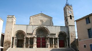
Pouzilhac

Last updated

Pouzilhac
Pouzilhac 30.JPG
A general view of Pouzilhac
Blason de la ville de Pouzilhac (30).svg
Location of Pouzilhac
Pouzilhac
France location map-Regions and departements-2016.svg
Red pog.svg
Pouzilhac
Languedoc-Roussillon-Midi-Pyrenees region location map.svg
Red pog.svg
Pouzilhac
Coordinates: 44°02′31″N4°34′50″E / 44.0419°N 4.5806°E / 44.0419; 4.5806
Country France
Region Occitania
Department Gard
Arrondissement Nîmes
Canton Redessan
Intercommunality Pont du Gard
Government
  Mayor (20202026) Thierry Astier [1]
Area
1
16.04 km2 (6.19 sq mi)
Population
 (2021) [2]
744
  Density46/km2 (120/sq mi)
Time zone UTC+01:00 (CET)
  Summer (DST) UTC+02:00 (CEST)
INSEE/Postal code
30207 /30210
Elevation168–261 m (551–856 ft)
(avg. 230 m or 750 ft)
1 French Land Register data, which excludes lakes, ponds, glaciers > 1 km2 (0.386 sq mi or 247 acres) and river estuaries.

Pouzilhac (French pronunciation: [puzijak] ; Occitan : Posilhac) is a French commune in the Gard department in southern France, formerly Languedoc-Roussillon.

Contents

Geography

Pouzilhac is situated on the right bank of the Rhone next to the route national 86 and its close access to the A7 motorway (Remoulins, Tavel, Bollène). [3] The commune covers 16 km² and has 733 inhabitants since the last population census in 2018. Surrounded by the municipalities of Valliguières, La Capelle-et-Masmolène and Saint-Paul-les-Fonts, Pouzilhac is located 14 km southwest of Bagnols-sur-Cèze, the largest city in the area. Located at 218 meters above sea level, the Ragouse is the main waterway that crosses the town of Pouzilhac.

History

The oldest occupation of the site dates back to the Bronze Age, around 2500 B.C. [3]

The Romans left many traces of their occupation, an inscription in the masonry of the church testifies to the existence of a "villa". [3]

During the medieval period, since the 11th century, a castrum existed, first mentioned in 1121 as Castrum de Posilhac. [4] :171 In 1176 it appeared as Villa de Posiliaco [4] In 1258, the municipal archives of Valliguières mention it as 'Posillanum' and in 1355 as 'Posilhacum'. [4] A Posillac took part in the First Crusade alongside the Count of Toulouse. [3]

It was during the religious wars in Europe in 1662 that the community took strategic importance with the construction of fortifications, and experienced a demographic progression. [3] Pouzilhac belonged to the viguerie of Roquemaure, a viguerie of the diocese of Uzès which included fourteen villages: Les Essarts, Lirac, Montfaucon, Pujaut, Rochefort, Roquemaure, Saint-Geniès-de-comolas, Saint-Hilaire-d'Ozilhan, Saint-Laurent-des-Arbres, Sauveterre, Saze, Tavel, and Valliguières. [4] :188

The 12 th century chapel of Saint-Privat de Pouzilhac appears under the name 'Priory Sainct-Privat de Pouzilhac' in 1620. [4] The chapel occupies a site located along the ancient Roman road linking Nîmes to Alba Augusta, on which ancient inscriptions and epitaphs have been discovered. [5] :525

Population

Historical population
YearPop.±%
1962328    
1968357+8.8%
1975372+4.2%
1982403+8.3%
1990373−7.4%
1999434+16.4%
2008612+41.0%
2010618+1.0%
2014660+6.8%
2018734+11.2%
2020739 [6] +0.7%

Sights

Chateau and eglise de Pouzilhac Chateau et eglise de Pouzilhac.jpg
Chateau and église de Pouzilhac

There is the Château de Pouzilhac and the Église Saint-Privat de Pouzilhac, (both private property) as well as the Chapelle Saint-Privat de Pouzilhac. There are also 4 UNESCO World Heritage Sites within a radius of 30 km around Pouzilhac: Nimes, Orange, Avignon and Pont du Gard.

See also

Related Research Articles

<span class="mw-page-title-main">Gard</span> Department in Occitanie, France

Gard is a department in Southern France, located in the region of Occitanie. It had a population of 748,437 as of 2019; its prefecture is Nîmes.

<span class="mw-page-title-main">Nîmes</span> Prefecture of Gard, Occitanie, France

Nîmes is the prefecture of the Gard department in the Occitanie region of Southern France. Located between the Mediterranean Sea and the Cévennes, the commune of Nîmes had an estimated population of 148,561 in 2019.

<span class="mw-page-title-main">Montfrin</span> Commune in Occitania, France

Montfrin is a commune in the Gard department in southern France.

<span class="mw-page-title-main">Uzès</span> Commune in Occitania, France

Uzès is a commune in the Gard department in the Occitanie region of Southern France. Uzès lies about 25 kilometres north-northeast of Nîmes, 40 kilometres west of Avignon, and 32 kilometres southeast of Alès.

<span class="mw-page-title-main">Saint-Gilles, Gard</span> Commune in Occitania, France

Saint-Gilles or Saint-Gilles-du-Gard is a commune in the Gard department in southern France.

<span class="mw-page-title-main">Roquemaure, Gard</span> Commune in Occitania, France

Roquemaure is a small town and commune in the Gard department of southern France. The town lies 12 kilometres north of Avignon on the right bank of the Rhône. In 2017 the commune had a population of 5,481.

<span class="mw-page-title-main">Arrondissement of Nîmes</span> Arrondissement in Occitania, France

The arrondissement of Nîmes is an arrondissement of France in the Gard department in the Occitanie region. It has 180 communes. Its population is 554,624 (2016), and its area is 3,158.1 km2 (1,219.3 sq mi).

The following is a list of the 23 cantons of the Gard department, in France, following the French canton reorganisation which came into effect in March 2015:

<span class="mw-page-title-main">A9 autoroute</span> Road in France

The A9 autoroute is a motorway in Southern France.

<span class="mw-page-title-main">Sauveterre, Gard</span> Commune in Occitania, France

Sauveterre is a commune in the Gard department in southern France.

<span class="mw-page-title-main">Manduel</span> Commune in Occitania, France

Manduel is a commune in the Gard department in southern France. Nîmes-Pont-du-Gard station, with high speed connections to Paris and Perpignan and regional services to Avignon, Nîmes and Montpellier, is situated in the commune.

<span class="mw-page-title-main">Caveirac</span> Commune in Occitanie, France

Caveirac is a commune and a village in the Gard department in southern France. It is located 8 km (5 mi) west of Nîmes and is the first village in the Vaunage reached when travelling from Nîmes. Its early history is unclear but it was in existence by the year 893. Its main feature is the Chateau of Caveiric, a notable building which now houses the town hall. The surrounding area of plains and low hills is agricultural and there are extensive vineyards.

<span class="mw-page-title-main">Saint-Privat-de-Champclos</span> Commune in Occitania, France

Saint-Privat-de-Champclos is a commune in the Gard department in the Occitania region in southern France. It is part of the canton of Rousson and of the arrondissement of Alès. Saint-Privat-de-Champclos has the INSEE code 30293, and the postal code is 30430. The area of Saint-Privat-de-Champclos is 11.64 km2.

<span class="mw-page-title-main">Saint-Pons-la-Calm</span> Commune in Occitania, France

Saint-Pons-la-Calm is a commune in the Gard department in southern France.

<span class="mw-page-title-main">Goudargues</span> Administrative division in Occitanie, France

Goudargues is a commune in the Gard department in southern France. Known locally as the Venise Gardoise, because of the canal that flows through it centre. This is lined with pavement cafés and shaded by a two rows of mature plane trees.

<span class="mw-page-title-main">Le Cailar</span> Commune in Occitanie, France

Le Cailar is a commune in the Gard department in southern France. It is located at the confluence of the River Vistre and the River Rhôny. It was an important port during the Iron Age at a time when lagoons connected to the Mediterranean Sea covered the adjoining low-lying land.

<span class="mw-page-title-main">Pujaut</span> Commune in Occitania, France

Pujaut is a commune in the Gard department in southern France. The village is situated on the south side of a small hill overlooking a flat plain that once formed the bed of a lake. The lake was drained at the beginning of the 17th century. The village is located 3.5 km west of the Rhône, 4.5 km north of Villeneuve-lès-Avignon and 5 km south of Roquemaure. In 2017 the commune had a population of 4,136.

The following is a timeline of the history of the city of Nîmes, France.

The canton of Redessan is an administrative division of the Gard department, southern France. It was created at the French canton reorganisation which came into effect in March 2015. Its seat is in Redessan.

The canton of Roquemaure is an administrative division of the Gard department, southern France. Its borders were modified at the French canton reorganisation which came into effect in March 2015. Its seat is in Roquemaure.

References

  1. "Répertoire national des élus: les maires" (in French). data.gouv.fr, Plateforme ouverte des données publiques françaises. 4 May 2022.
  2. "Populations légales 2021". The National Institute of Statistics and Economic Studies. 28 December 2023.
  3. 1 2 3 4 5 "Communes - Pont du Gard". 14 January 2015. Archived from the original on 14 January 2015. Retrieved 30 April 2023.
  4. 1 2 3 4 5 Eugène Germer-Durand, 'Dictionnaire topographique du département du Gard, Imprimerie impériale, Paris, 1868
  5. Michel Provost, Carte archéologique de la Gaule (30/2 GARD), Académie des Inscriptions et Belles-Lettres, 1999.
  6. "Populations légales 2006 − Commune de Pouzilhac (30207)". www.insee.fr. Retrieved 30 April 2023.