Saint-Jean-du-Gard

Last updated

Saint-Jean-du-Gard
Pont St Jean du Gard 2007.jpg
Bridge over the Gardon
Blason de la ville de Saint-Jean-du-Gard (30).svg
Location of Saint-Jean-du-Gard
Saint-Jean-du-Gard
France location map-Regions and departements-2016.svg
Red pog.svg
Saint-Jean-du-Gard
Languedoc-Roussillon-Midi-Pyrenees region location map.svg
Red pog.svg
Saint-Jean-du-Gard
Coordinates: 44°06′20″N3°53′13″E / 44.1056°N 3.8869°E / 44.1056; 3.8869
Country France
Region Occitania
Department Gard
Arrondissement Alès
Canton La Grand-Combe
Intercommunality Alès Agglomération
Government
  Mayor (20232026) Pierre Aiguillon [1]
Area
1
41.64 km2 (16.08 sq mi)
Population
 (2021) [2]
2,480
  Density60/km2 (150/sq mi)
Time zone UTC+01:00 (CET)
  Summer (DST) UTC+02:00 (CEST)
INSEE/Postal code
30269 /30270
Elevation168–817 m (551–2,680 ft)
(avg. 189 m or 620 ft)
1 French Land Register data, which excludes lakes, ponds, glaciers > 1 km2 (0.386 sq mi or 247 acres) and river estuaries.

Saint-Jean-du-Gard (Occitan : Sant Joan de Gardonenca) is a commune in the Gard department in southern France.

Contents

History

This city of the Cévennes, first mentioned in a 12th-century papal bull (San Johannis de Gardonnenca cum villa), was very much influenced by Protestantism in the 16th century and became the Mecca of the camisards' resistance.

Thanks to the silk industry, the village experienced a period of prosperity that lasted from the 19th century to the 20th century. This city now owes much of its economy to tourism. A heritage railway runs from Saint-Jean-du-Gard to Anduze with a stop at the Bambouseraie de Prafrance, which attracts 150,000 tourists a year.

The Scottish author Robert Louis Stevenson reached the town on 3 October 1878, as recounted in his book Travels with a Donkey in the Cévennes . Here he sold his donkey Modestine, and took a stagecoach to Alès:

It was a long descent upon St. Jean du Gard, and we met no one but a carter, visible afar off by the glint of the moon on his extinguished lantern. Before ten o'clock we had got in and were at supper; fifteen miles and a stiff hill in little beyond six hours! ... On examination, on the morning of October 4th, Modestine was pronounced unfit for travel. She would need at least two days' repose according to the ostler; but I was now eager to reach Alais for my letters; and, being in a civilised country of stagecoaches, I determined to sell my lady-friend and be off by the diligence that afternoon. Our yesterday's march, with the testimony of the driver who had pursued us up the long hill of St. Pierre, spread a favourable notion of my donkey's capabilities. Intending purchasers were aware of an unrivalled opportunity. Before ten I had an offer of twenty-five francs; and before noon, after a desperate engagement, I sold her, saddle and all, for five-and-thirty. The pecuniary gain is not obvious, but I had bought freedom into the bargain. [3]

The Robert Louis Stevenson Trail (GR 70), a popular long-distance path following Stevenson's approximate route, finishes in the town at a fountain built to commemorate Stevenson's arrival. [4]

Geography

Climate

Saint-Jean-du-Gard has a hot-summer Mediterranean climate (Köppen climate classification Csa). The average annual temperature in Saint-Jean-du-Gard is 13.8 °C (56.8 °F). The average annual rainfall is 1,437.7 mm (56.60 in) with November as the wettest month. The temperatures are highest on average in July, at around 23.1 °C (73.6 °F), and lowest in January, at around 5.8 °C (42.4 °F). The highest temperature ever recorded in Saint-Jean-du-Gard was 43.4 °C (110.1 °F) on 28 June 2019; the coldest temperature ever recorded was −12.4 °C (9.7 °F) on 12 February 2012.

Climate data for Saint-Jean-du-Gard (1991−2020 normals, extremes 1989−present)
MonthJanFebMarAprMayJunJulAugSepOctNovDecYear
Record high °C (°F)22.9
(73.2)
24.3
(75.7)
27.5
(81.5)
31.4
(88.5)
35.4
(95.7)
43.4
(110.1)
39.4
(102.9)
41.7
(107.1)
37.6
(99.7)
32.5
(90.5)
23.9
(75.0)
22.0
(71.6)
43.4
(110.1)
Mean daily maximum °C (°F)10.6
(51.1)
12.3
(54.1)
16.2
(61.2)
18.9
(66.0)
23.0
(73.4)
27.6
(81.7)
30.7
(87.3)
30.5
(86.9)
25.3
(77.5)
19.6
(67.3)
14.3
(57.7)
10.9
(51.6)
20.0
(68.0)
Daily mean °C (°F)5.8
(42.4)
6.6
(43.9)
9.9
(49.8)
12.5
(54.5)
16.3
(61.3)
20.4
(68.7)
23.1
(73.6)
22.8
(73.0)
18.4
(65.1)
14.3
(57.7)
9.4
(48.9)
6.3
(43.3)
13.8
(56.8)
Mean daily minimum °C (°F)1.1
(34.0)
0.9
(33.6)
3.5
(38.3)
6.2
(43.2)
9.7
(49.5)
13.1
(55.6)
15.4
(59.7)
15.0
(59.0)
11.6
(52.9)
8.9
(48.0)
4.6
(40.3)
1.7
(35.1)
7.6
(45.7)
Record low °C (°F)−10.0
(14.0)
−12.4
(9.7)
−11.1
(12.0)
−3.6
(25.5)
0.0
(32.0)
4.9
(40.8)
7.0
(44.6)
6.5
(43.7)
3.8
(38.8)
−3.1
(26.4)
−8.4
(16.9)
−11.5
(11.3)
−12.4
(9.7)
Average precipitation mm (inches)117.9
(4.64)
79.4
(3.13)
97.4
(3.83)
118.4
(4.66)
113.3
(4.46)
60.1
(2.37)
47.6
(1.87)
64.0
(2.52)
173.3
(6.82)
211.9
(8.34)
213.7
(8.41)
140.7
(5.54)
1,437.7
(56.60)
Average precipitation days (≥ 1.0 mm)8.46.15.97.78.15.75.05.16.310.29.58.486.4
Source: Météo-France [5]

Population

Historical population
YearPop.±% p.a.
1793 4,134    
1800 3,105−4.01%
1806 3,755+3.22%
1821 3,862+0.19%
1831 4,128+0.67%
1836 4,296+0.80%
1841 4,192−0.49%
1846 4,193+0.00%
1851 4,487+1.36%
1856 4,450−0.17%
1861 4,240−0.96%
1866 3,957−1.37%
1872 3,885−0.31%
1876 3,978+0.59%
1881 3,659−1.66%
1886 3,712+0.29%
1891 3,586−0.69%
1896 3,290−1.71%
YearPop.±% p.a.
1901 3,228−0.38%
1906 3,582+2.10%
1911 3,308−1.58%
1921 2,804−1.64%
1926 2,757−0.34%
1931 2,577−1.34%
1936 2,445−1.05%
1946 2,437−0.03%
1954 2,442+0.03%
1962 2,437−0.03%
1968 2,427−0.07%
1975 2,378−0.29%
1982 2,423+0.27%
1990 2,441+0.09%
1999 2,563+0.54%
2007 2,655+0.44%
2012 2,696+0.31%
2017 2,433−2.03%
Source: EHESS [6] and INSEE (1968-2017) [7]

Notable residents

Augustine Soubeiran was born here in 1858 and she founded a school and a society in Sydney. [8] Place Augustine Subeiran is named for her. [9]

See also

Related Research Articles

<span class="mw-page-title-main">Aigues-Mortes</span> Commune in Occitanie, France

Aigues-Mortes is a commune in the Gard department in the Occitania region of southern France. The medieval city walls surrounding the city are well preserved. Situated on the junction of the Canal du Rhône à Sète and the Chenal Maritime to Le Grau-du-Roi, the town is a transit center for canal craft and Dutch barges.

Camisards were Huguenots of the rugged and isolated Cévennes region and the neighbouring Vaunage in southern France. In the early 1700s, they raised a resistance against the persecutions which followed Louis XIV's Revocation of the Edict of Nantes, making Protestantism illegal. The Camisards operated throughout the mainly Protestant Cévennes and Vaunage regions including parts of the Camargue around Aigues Mortes. The revolt broke out in 1702, with the worst of the fighting continuing until 1704, then skirmishes until 1710 and a final peace by 1715. The Edict of Tolerance was not finally signed until 1787.

<span class="mw-page-title-main">Cévennes</span> Mountain range in France

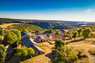
The Cévennes is a cultural region and range of mountains in south-central France, on the south-east edge of the Massif Central. It covers parts of the départements of Ardèche, Gard, Hérault and Lozère. Rich in geographical, natural, and cultural significance, portions of the region are protected within the Cévennes National Park, the Cévennes Biosphere Reserve (UNESCO), as well as a UNESCO World Heritage Site: Causses and the Cévennes, Mediterranean agro-pastoral Cultural Landscape. The area has been inhabited since 400,000 BCE and has numerous megaliths which were erected beginning around 2500 BCE. As an agriculturally-rich area, but not a suitable location for cities, the Cévennes developed a wide diversity of pastoral systems, including transhumance. The irrigation and road networks put in place in the early Middle Ages for these pastoral systems are still in use today.

<span class="mw-page-title-main">Cévennes National Park</span> French national park in Lozère, Gard, Ardèche and Aveyron

Cévennes National Park is a French national park located in Southern France, in the mountainous area of Cévennes.

<span class="mw-page-title-main">Le Vigan, Gard</span> Subprefecture and commune in Occitania, France

Le Vigan is a commune in the Gard department in southern France. It is a sub-prefecture of the department.

<span class="mw-page-title-main">Florac</span> Part of Florac-Trois-Rivières in Occitania, France

Florac is a former commune of the Lozère department in southern France. On 1 January 2016, it was merged into the new commune of Florac-Trois-Rivières.

<span class="mw-page-title-main">Le Pont-de-Montvert</span> Part of Pont-de-Montvert-Sud-Mont-Lozère in Occitania, France

Le Pont-de-Montvert is a former commune in the Lozère département in southern France. On 1 January 2016, it was merged into the new commune of Pont-de-Montvert-Sud-Mont-Lozère.

<i>Travels with a Donkey in the Cévennes</i> Book by Robert Louis Stevenson

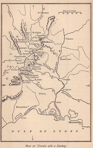
Travels with a Donkey in the Cévennes (1879) is one of Robert Louis Stevenson's earliest published works and is considered a pioneering classic of outdoor literature.

<span class="mw-page-title-main">François Langlade</span> French Catholic abbot (died 1702)

François de Langlade du Chayla was the French Catholic Abbé of Chaila, Archpriest of the Cevennes and Inspector of Missions of the Cevennes. His brutal repression of French (Protestant) Huguenots by means of torture caused his assassination and sparked the War of the Camisards.

<span class="mw-page-title-main">Le Monastier-sur-Gazeille</span> Commune in Auvergne-Rhône-Alpes, France

Le Monastier-sur-Gazeille is a commune in the Haute-Loire department in south-central France.

<span class="mw-page-title-main">Cheylard-l'Évêque</span> Commune in Occitania, France

Cheylard-l'Évêque is a commune in the Lozère department in southern France.

<span class="mw-page-title-main">Saint-Germain-de-Calberte</span> Commune in Occitania, France

Saint-Germain-de-Calberte is a commune in the Lozère department in southern France.

<span class="mw-page-title-main">Saint-Étienne-Vallée-Française</span> Commune in Occitania, France

Saint-Étienne-Vallée-Française is a commune in the Lozère department in southern France.

<span class="mw-page-title-main">Mont Lozère</span> Mountain in southern France

Mont Lozère is the highest peak in the Cévennes, a subrange of the Massif Central in France. It is 1,699 metres (5,574 ft) above sea level and lies within the Cévennes National Park.

<span class="mw-page-title-main">Saint-André-de-Lancize</span> Commune in Occitania, France

Saint-André-de-Lancize is a commune in the Lozère department in southern France.

<span class="mw-page-title-main">Cassagnas</span> Commune in Occitania, France

Cassagnas is a commune in the Lozère department in southern France.

<span class="mw-page-title-main">Saint-Julien-d'Arpaon</span> Former commune in Lozère, France

Saint-Julien-d'Arpaon is a former commune in the Lozère department in southern France. On 1 January 2016, it was merged into the new commune of Cans-et-Cévennes. Its population was 93 in 2019.

<span class="mw-page-title-main">Mialet, Gard</span> Commune in Occitania, France

Mialet is a commune in the Gard department in southern France.

<span class="mw-page-title-main">Le Bouchet-Saint-Nicolas</span> Commune in Auvergne-Rhône-Alpes, France

Le Bouchet-Saint-Nicolas is a commune in the Haute-Loire department in south-central France.

<span class="mw-page-title-main">GR 70</span>

The GR 70, also known as the Chemin de Stevenson or the Robert Louis Stevenson Trail, is a Grande Randonnée that runs for approximately 225 kilometres (140 mi) through the French departments of Haute-Loire, Lozère and Gard in a generally north–south direction from Le Monastier-sur-Gazeille to Saint-Jean-du-Gard. It follows approximately the route taken by Robert Louis Stevenson in 1878, a journey described in his book Travels with a Donkey in the Cévennes.

References

  1. "Répertoire national des élus: les maires" (in French). data.gouv.fr, Plateforme ouverte des données publiques françaises. 30 November 2023.
  2. "Populations légales 2021". The National Institute of Statistics and Economic Studies. 28 December 2023.
  3. Stevenson, Robert Louis (1905) [1879]. "The Country of the Camisards"  . Travels with a Donkey in the Cevennes. New York: Charles Scribner's Sons. p.  195–196  via Wikisource.
  4. Castle, Alan (2007). "Stage 12 – Saint-Germain-de-Calberte to Saint-Jean-du-Gard". The Robert Louis Stevenson Trail (2nd ed.). Cicerone. pp. 171–182. ISBN   978-1-85284-511-7.
  5. "Fiche Climatologique Statistiques 1991-2020 et records" (PDF) (in French). Météo-France . Retrieved 3 September 2022.
  6. Des villages de Cassini aux communes d'aujourd'hui: Commune data sheet Saint-Jean-du-Gard, EHESS (in French).
  7. Population en historique depuis 1968, INSEE
  8. Sherington, G. E., "Augustine Soubeiran (1858–1933)", Australian Dictionary of Biography, Canberra: National Centre of Biography, Australian National University, retrieved 22 March 2024
  9. "Augustine Soubeiran". Alliance Francaise de Sydney. Retrieved 22 March 2024.