Ners

Last updated

Ners
Ners.jpg
A general view of Ners
Blason de la ville de Ners (30).svg
Location of Ners
Ners
France location map-Regions and departements-2016.svg
Red pog.svg
Ners
Languedoc-Roussillon-Midi-Pyrenees region location map.svg
Red pog.svg
Ners
Coordinates: 44°01′38″N4°09′34″E / 44.0272°N 4.1594°E / 44.0272; 4.1594
Country France
Region Occitania
Department Gard
Arrondissement Alès
Canton Quissac
Intercommunality Alès Agglomération
Government
  Mayor (20202026) Patrice Pupet [1]
Area
1
4.96 km2 (1.92 sq mi)
Population
 (Jan. 2020) [2]
712
  Density140/km2 (370/sq mi)
Time zone UTC+01:00 (CET)
  Summer (DST) UTC+02:00 (CEST)
INSEE/Postal code
30188 /30360
Elevation79–181 m (259–594 ft)
(avg. 123 m or 404 ft)
1 French Land Register data, which excludes lakes, ponds, glaciers > 1 km2 (0.386 sq mi or 247 acres) and river estuaries.

Ners is a commune in the Gard department in southern France.

Contents

History

Ners is part of a territory inhabited long before the Roman presence in the region.

The village is located along the ancient road 'voie Régordane' going from Saint-Gilles to Puy-en-Velay. Along this road traders, pilgrims, crusaders and knights crossed the river Gardon.

In 1211 Ners is first time reported as a place of residence with the "castrum nercium" - a watchtower of the twelfth century. This tower was probably constructed as an outpost to the village of Vezenobres as well as to protect the few inhabitants of the village. The tower was gradually expanded and in 1480 it retained its castle walls and is to be considered the oldest building in the village.

Etymology

Etymologically the name can be derived from "Nertius", a Gallo-Roman person with great prestige in ancient times. A manuscript from 1247 mentions the name "Nercium" and in 1547 "Ners".

Population

Historical population
YearPop.±%
1789425    
1856561+32.0%
1901403−28.2%
1954354−12.2%
1962347−2.0%
1968357+2.9%
1975362+1.4%
1982473+30.7%
1990544+15.0%
1999618+13.6%
2008672+8.7%

See also

Related Research Articles

<span class="mw-page-title-main">Aigues-Mortes</span> Commune in Occitanie, France

Aigues-Mortes is a commune in the Gard department in the Occitania region of southern France. The medieval city walls surrounding the city are well preserved. Situated on the junction of the Canal du Rhône à Sète and the Chenal Maritime to Le Grau-du-Roi, the town is a transit center for canal craft and Dutch barges.

<span class="mw-page-title-main">Gard</span> Department in Occitanie, France

Gard is a department in Southern France, located in the region of Occitanie. It had a population of 748,437 as of 2019; its prefecture is Nîmes.

<span class="mw-page-title-main">Uzès</span> Commune in Occitania, France

Uzès is a commune in the Gard department in the Occitanie region of Southern France. In 2017, it had a population of 8,454. Uzès lies about 25 kilometres north-northeast of Nîmes, 40 kilometres west of Avignon, and 32 kilometres south-east of Alès.

<span class="mw-page-title-main">Lunel, Hérault</span> Commune in Occitania, France

Lunel is a commune in the Hérault department in southern France. Lunel is located 21 km (13 mi) east of Montpellier and 28 km (17 mi) southwest of Nîmes (Gard). Lunel station has rail connections to Narbonne, Montpellier, Nîmes and Avignon.

<span class="mw-page-title-main">Sommières</span> Commune in Occitania, France

Sommières is a commune in the Gard department in southern France, located at the border with the Hérault department.

<span class="mw-page-title-main">La Garde, Var</span> Commune in Provence-Alpes-Côte dAzur, France

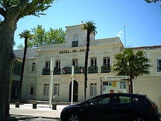
La Garde is a seaside commune in the Var department in the Provence-Alpes-Côte d'Azur region in Southeastern France.

<span class="mw-page-title-main">Ouanne</span> Commune in Bourgogne-Franche-Comté, France

Ouanne is a commune in the Yonne department in Bourgogne-Franche-Comté in north-central France, in the natural region of Forterre.

<span class="mw-page-title-main">Sillegny</span> Commune in Grand Est, France

Sillegny is a commune in the Moselle department in Grand Est in north-eastern France.

<span class="mw-page-title-main">Vers-Pont-du-Gard</span> Commune in Occitania, France

Vers-Pont-du-Gard is a commune in the Gard department in southern France.

<span class="mw-page-title-main">Théziers</span> Commune in Occitania, France

Théziers is a commune in the Gard department in the Occitanie region in southern France.

<span class="mw-page-title-main">Sauveterre, Gard</span> Commune in Occitania, France

Sauveterre is a commune in the Gard department in southern France.

<span class="mw-page-title-main">Pouzilhac</span> Commune in Occitania, France

Pouzilhac is a French commune in the Gard department in southern France, formerly Languedoc-Roussillon.

<span class="mw-page-title-main">Hulluch</span> Commune in Hauts-de-France, France

Hulluch is a commune in the Pas-de-Calais department in the Hauts-de-France region of France.

<span class="mw-page-title-main">Goudargues</span> Administrative division in Occitanie, France

Goudargues is a commune in the Gard department in southern France. Known locally as the Venise Gardoise, because of the canal that flows through it centre. This is lined with pavement cafés and shaded by a two rows of mature plane trees.

Garrigues-Sainte-Eulalie is a commune in the Gard department in southern France. It lies 54 km (34 mi) from Montpellier.

<span class="mw-page-title-main">Fourques, Gard</span> Commune in Occitania, France

Fourques is a commune and a village in the southeastern corner of the Gard department in southern France, some 4 km (2.5 mi) north of Arles. The village is located at the confluence of the Rhone and the Little Rhone and sprang up adjoining a bridge across the latter built by the Romans. A historic suspension bridge was constructed across the Little Rhone early in the nineteenth century.

<span class="mw-page-title-main">Arras-sur-Rhône</span> Commune in Auvergne-Rhône-Alpes, France

Arras-sur-Rhône is a commune in the Ardèche department in the Auvergne-Rhône-Alpes region of southern France.

<span class="mw-page-title-main">Acheux-en-Amiénois</span> Commune in Hauts-de-France, France

Acheux-en-Amiénois is a commune in the Somme department in Hauts-de-France in northern France.

<span class="mw-page-title-main">Sancergues</span> Commune in Centre-Val de Loire, France

Sancergues is a commune in the Cher department in the Centre-Val de Loire region, France.

<span class="mw-page-title-main">Niderviller</span> Commune in Grand Est, France

Niderviller is a commune in the Moselle department in Grand Est in north-eastern France. It is mostly known for the Niderviller pottery, established in 1735 and still producing there.

References

  1. "Répertoire national des élus: les maires". data.gouv.fr, Plateforme ouverte des données publiques françaises (in French). 2 December 2020.
  2. "Populations légales 2020". The National Institute of Statistics and Economic Studies. 29 December 2022.