Blue Waters, Antigua and Barbuda

Last updated
Blue Waters
Village
View From Rock Cottage to Soldiers Bay.jpg
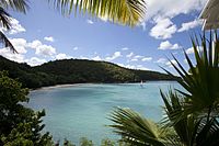
View from the Blue Waters Hotel
CountryFlag of Antigua and Barbuda.svg Antigua and Barbuda
Island Antigua
Parish Saint John
Government
  MP Charles Fernandez
Population
 (2011)
  Total235
Time zone UTC-4 (AST)
Closest airport V.C. Bird International Airport
Constituency St. John's Rural North

Blue Waters is a village in Saint John Parish, Antigua and Barbuda.

Demographics

Blue Waters has one enumeration district, 30600 Blue Waters.

Ethnic [1]
Q48 EthnicCounts%
African descendent4418.78%
Caucasian/White6628.17%
East Indian/India156.57%
Mixed (Black/White)10.47%
Mixed (Other)3615.49%
Hispanic41.88%
Syrian/Lebanese3414.55%
Other2811.74%
Don't know/Not stated62.35%
Total235100.00%
Religion [2]
Q49 ReligionCounts%
Adventist20.94%
Anglican2410.33%
Methodist156.57%
Moravian62.35%
Nazarene10.47%
None/no religion197.98%
Pentecostal93.76%
Roman Catholic10243.19%
Other4519.25%
Don't know/Not stated125.16%
Total235100.00%
Country of birth [3]
Q58. Country of birthCounts%
Other Latin or North American countries10.47%
Antigua and Barbuda5623.94%
Other Caribbean countries72.82%
Canada72.82%
Other Asian countries72.82%
Other European countries177.04%
Dominica20.94%
Dominican Republic10.47%
Guyana72.82%
Jamaica83.29%
Monsterrat41.88%
St. Kitts and Nevis20.94%
St. Vincent and the Grenadines72.82%
Syria135.63%
Trinidad and Tobago31.41%
United Kingdom93.76%
USA7732.86%
USVI United States Virgin Islands10.47%
Not Stated72.82%
Total235100.00%
Country of citizenship [4]
Q71 Country of Citizenship 1Counts%
Antigua and Barbuda14461.03%
Other Caribbean countries31.41%
Canada10.47%
Other Asian and Middle Eastern countries31.41%
Monsterrat10.47%
St. Vincent and the Grenadines41.88%
United Kingdom10.47%
USA6226.29%
Other countries104.23%
Not Stated62.35%
Total235100.00%
Country of second/dual citizenship [5]
Q71 Country of Citizenship 2Counts%
Other Caribbean countries44.71%
Canada88.24%
Other Asian and Middle Eastern countries1212.94%
Dominica11.18%
Guyana65.88%
Jamaica77.06%
Monsterrat33.53%
St. Vincent and the Grenadines22.35%
Trinidad and Tobago22.35%
United Kingdom1212.94%
USA2728.24%
Other countries1010.59%
Total94100.00%
NotApp :141

Related Research Articles

<span class="mw-page-title-main">Saint Mary, Antigua and Barbuda</span> Parish in Antigua and Barbuda

Saint Mary, officially the Parish of Saint Mary, is a parish of Antigua and Barbuda on the island of Antigua. Saint Mary borders Saint John to the north, and Saint Paul to the east. Saint Mary is dominated by the Shekerley Mountains, and its northern border is largely defined by the mountains, and by Cooks Creek. The largest city in the parish is Bolans, home to the Jolly Harbour neighbourhood, and the parish church is located in Old Road. Saint Mary was created with the other five original parishes on 11 January 1692. It had a population of 7,341 in 2011, and 8,141 in 2018.

<span class="mw-page-title-main">Saint Paul, Antigua and Barbuda</span> Parish in Antigua and Barbuda

Saint Paul, officially the Parish of Saint Paul, is a parish of Antigua and Barbuda on the island of Antigua. Saint Paul borders Saint Peter and Saint John to the north, Saint Mary to the west, and Saint Philip to the east. Saint Paul is dominated by farmland in the north, with various creeks and Potworks Dam marking its northern border, and low-lying hills to the south, defining its western border with Saint Mary. The largest city fully within the parish is Liberta, the fourth largest city in the country. The parish capital, and the location of the parish church, is Falmouth. The main economic and tourism hub of the parish is English Harbour. Saint Paul was created with the other five original parishes on 11 January 1692. It had a population of 9,004 in 2018.

<span class="mw-page-title-main">Saint Peter, Antigua and Barbuda</span> Parish in Antigua and Barbuda

Saint Peter, officially the Parish of Saint Peter, is a parish of Antigua and Barbuda on the island of Antigua. Saint Peter borders Saint Paul to the south, Saint Philip to the east, and Saint George and Saint John to the west. Saint Peter is dominated by farmland, savanna, and undeveloped fields, and its borders are not well-defined. The largest city fully within the parish is Parham, which is also the capital. However, the portion of the city of All Saints in Saint Peter is significantly larger than Parham. Saint Peter was created with the other five original parishes on 11 January 1692. It had a population of 5,325 in 2011.

Long Island also known as Jumby Bay is an island off the northeast coast of Antigua. It is located off the northern tip of the Parham Peninsula, about 2.5 kilometres (1.6 mi) from Dutchman Bay on Antigua. It is the fifth largest island of Antigua and Barbuda.

<span class="mw-page-title-main">Barbuda-North</span> Village and enumeration district in Barbuda, Antigua and Barbuda

Barbuda North is a village and enumeration district on the island of Barbuda.

<span class="mw-page-title-main">Barbuda-South</span> Village and Enumeration District in Barbuda

Barbuda-South or Barbuda South River Road, is a village and enumeration district on the island of Barbuda.

<span class="mw-page-title-main">Golden Grove, St. John's</span> Village in Antigua

Golden Grove is a village in Saint John Parish, Antigua and Barbuda.

Montpelier is a small village in Saint Philip Parish, Antigua and Barbuda.

<span class="mw-page-title-main">Clarkes Hill, Antigua and Barbuda</span> Town in Antigua, Antigua and Barbuda

Clarkes Hill is a town in Saint John Parish, Antigua and Barbuda.

<span class="mw-page-title-main">Multiracial Antiguans and Barbudans</span>

Multiracial Antiguans and Barbudans are Antiguans and Barbudans of more than one race or ethnicity.

<span class="mw-page-title-main">Barbuda-East</span> Village and enumeration district in Barbuda, Antigua and Barbuda

Barbuda-East is a village and enumeration district on the island of Barbuda.

City Centre is a Major Division/Area within the city of St. John's, Antigua and Barbuda.

McKinnon's is a major city in the Major Division of North Coast, Saint John Parish, Antigua and Barbuda.

Downtown, officially City Center Downtown, is an enumeration district in the Major Division of Upper Fort Road, St. John's, Antigua and Barbuda.

Twenty Hill is a historic site and sparsely populated unincorporated area in southern Parham.

Montclear is a major city in All Saints Northwest, Saint John, Antigua and Barbuda. It had a population of 1,246 in the 2011 census. It has an area of 0.7 square kilometres.

<span class="mw-page-title-main">Housing in Barbuda</span>

On the island of Barbuda, which is part of the nation of Antigua and Barbuda, the housing industry is a major economic sector. The majority of households, or 68.38% of all households, are owner-occupied homes.

<span class="mw-page-title-main">Long Bay, Antigua and Barbuda</span> Coastal settlement in Saint Philip, Antigua

Long Bay is a coastal settlement in Saint Philip, Antigua and Barbuda.

Herberts is a major town in Saint John, Antigua and Barbuda.

References

  1. (PDF) https://redatam.org/binatg/RpWebUtilities.exe/reporte.pdf?LFN=RpBases\Tempo\106329\~tmp_106329151.pdf.{{cite web}}: Missing or empty |title= (help)
  2. (PDF) https://redatam.org/binatg/RpWebUtilities.exe/reporte.pdf?LFN=RpBases\Tempo\106329\~tmp_106329181.pdf.{{cite web}}: Missing or empty |title= (help)
  3. (PDF) https://redatam.org/binatg/RpWebUtilities.exe/reporte.pdf?LFN=RpBases\Tempo\106329\~tmp_106329211.pdf.{{cite web}}: Missing or empty |title= (help)
  4. (PDF) https://redatam.org/binatg/RpWebUtilities.exe/reporte.pdf?LFN=RpBases\Tempo\106329\~tmp_106329241.pdf.{{cite web}}: Missing or empty |title= (help)
  5. (PDF) https://redatam.org/binatg/RpWebUtilities.exe/reporte.pdf?LFN=RpBases\Tempo\106329\~tmp_106329271.pdf.{{cite web}}: Missing or empty |title= (help)