Related Research Articles

Tehama County is a county located in the northern part of the U.S. state of California. As of the 2010 census, the population was 63,463. The county seat and largest city is Red Bluff.
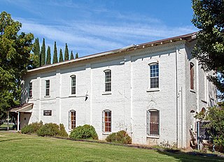
Tehama is a city in Tehama County, California, United States. The population was 418 at the 2010 census, down from 432 at the 2000 census.
Woodson Bridge State Recreation Area is a woodland park located along the Sacramento River in Tehama County, California.
KALF is a commercial radio station licensed to Red Bluff, California, and located in Chico, California, broadcasting to Butte, Shasta, Tehama, and Glenn Counties on 95.7 FM. KALF airs a country music format branded as "New Country 95-7 The Wolf".
Rosewood is an unincorporated community in Tehama County, in the U.S. state of California. Rosewood is situated along State Route 36 at the junction with County Route A5 to Cottonwood.

Kirkwood is an unincorporated community in Tehama County, California. It lies at an elevation of 220 feet.
Dye Creek is an 18.2-mile-long (29.3 km) watercourse in Tehama County, California, United States, that is tributary to the Sacramento River. Dye Creek's watershed is situated in north-central California. The Dye Creek watershed contains rugged terrain areas of oak-studded forest, and also provides habitat for numerous understory flora and fauna. An example forb found in the watershed is the poppy Calochortus luteus, which is at its northern limit around the Dye Creek watershed.
Payne's Creek is a 33.7-mile-long (54.2 km) natural watercourse in Tehama County, California. The creek was apparently originally called Paines Creek according to an 1879 land survey map of the area. The town of Paynes Creek was named after the creek. The creek most likely was named after James S. Payne, the proprietor of a local sawmill.
Rancho Saucos was a 22,212-acre (89.89 km2) Mexican land grant in present-day Tehama County, California given in 1844 by Governor Manuel Micheltorena to Robert H. Thomes. The name means "Ranch of the Elder trees". The grant extended along the west side of the Sacramento River from Elder Creek and Rancho Las Flores on the north to Thomes Creek on the south, and encompassed present-day Tehama.
Beegum Creek is a stream located in Shasta and Tehama counties, in the U.S. state of California. The stream runs 16 miles (26 km) before it empties into Cottonwood Creek.
Antelope Creek is a tributary of the Sacramento River, located in the Lassen National Forest in Tehama County, California. The creek is home to both spring-run Chinook salmon and steelhead trout.
Beegum is an unincorporated community in Shasta and Tehama counties, in the U.S. state of California.
Cold Fork is an unincorporated community in Tehama County, in the U.S. state of California.
Henleyville is an unincorporated community in Tehama County, in the U.S. state of California.
Hooker is an unincorporated community in Tehama County, in the U.S. state of California.
Lowrey is an unincorporated community in Tehama County, in the U.S. state of California.
Lyonsville is an unincorporated community in Tehama County, in the U.S. state of California.
Red Bank is an unincorporated community in Tehama County, in the U.S. state of California.
Skinner Mill Place is an unincorporated community in Tehama County, in the U.S. state of California.
Squaw Hill is an unincorporated community in Tehama County, in the U.S. state of California.
References
- ↑ U.S. Geological Survey Geographic Names Information System: Blunt, California
- ↑ "Place Names" (PDF). Tehama County Department of Education. Archived from the original (PDF) on 8 May 2017. Retrieved 25 March 2018.
Municipalities and communities of Tehama County, California, United States | ||
|---|---|---|
| Cities |  | |
| CDPs | ||
| Unincorporated communities | ||
| Footnotes | ‡This populated place also has portions in an adjacent county or counties | |
Coordinates: 40°14′31″N122°17′28″W / 40.24194°N 122.29111°W
| This Tehama County, California-related article is a stub. You can help Wikipedia by expanding it. |