El Camino, California

Last updated
El Camino
Haystack and barn of Jo Webster, farmer in El Camino district, Tehema County, California.jpg
Haystack and barn in El Camino district farm, 1940
USA California location map.svg
Red pog.svg
El Camino
Location in California
Coordinates: 40°02′28″N122°10′14″W / 40.04111°N 122.17056°W / 40.04111; -122.17056
Country Flag of the United States (23px).png  United States
State Flag of California.svg  California
County Tehama
Elevation
79 m (259 ft)
Website elcaminoirrigation.specialdistrict.org

El Camino (Spanish for "The Path") is a rural community and irrigation district near Gerber in Tehama County, in the U.S. state of California. [1] [2] As a special district, the El Camino Irrigation District is owned by local residents who govern it through locally elected board members. [3] [4] [5]

Contents

Historically, the district was a subdivision, in California law, of what used to be the Finnell Ranch, which in the early 20th century was part of the El Camino Colony. [6] [2]

History

From Mexican land grant to the Finnell Ranch

Finnell Land Company holdings on old Saucos Rancho, near Tehama city, 1903 Saucos-Finnell 1903 01.jpg
Finnell Land Company holdings on old Saucos Rancho, near Tehama city, 1903

The Finnell Ranch was, before the Great Depression, a 48,000 acres (19,000 ha) ranch devoted to beef cattle owned by Simpson Finnell Sr, who bought it in 1910. [7] Finnell's parents had earlier leased the 2,000 acres (810 ha) J. R. Walsh ranch at St John, and later he and they moved to Tacoma and bought land as the Finnell Land Company. [8] At one point Finnell owned 50,000 acres (20,000 ha) for his cattle operations, stretching from Proberta to Corning and including range land in the mountains. [7]

The ranch had its own railroad siding, named Finnell, between Tehama and Richfield later to be the path of the Finnell Road. [9] 4,800 acres (1,900 ha) of the old ranch holding was bought, around 1910, by the Richfield Land Company in order to form the town of Richfield, which contained the old Finnell Ranch headquarters building. [10]

The ranch was originally a 22,095 acres (8,942 ha) land grant to Robert Hasty Thomas called Rancho de Los Saucos or Rancho de Thomes, [11] and the brick house erected by Robert Thomes there somewhere around the late 1860s or early 1870s stood on Finnell Ranch until 1943, when it was destroyed by fire. [6] [8]

Subdivision in the 1920s, irrigation district, and grange

An El Camino Real for Tehama County was created near Corning and Maywood Colony (an orchard district southeast of Thomes Creek ) by early 20th-century community boosters (Corning Daily Observer, 1914) El Camino Real - Tehama County.jpg
An El Camino Real for Tehama County was created near Corning and Maywood Colony (an orchard district southeast of Thomes Creek ) by early 20th-century community boosters (Corning Daily Observer, 1914)
Advertisement for the El Camino subdivision (The Corning Daily Observer, April 9, 1920) Opening El Camino Rancho Formerly Finnell or Elder Creek Rancho.jpg
Advertisement for the El Camino subdivision (The Corning Daily Observer, April 9, 1920)
"Hospitality headquarters at El Camino" image from an ad promising "semi-tropical verdure" and real-estate wealth in Tehama County (Corning Advance, 1927) Hospitality headquarters at El Camino.jpg
"Hospitality headquarters at El Camino" image from an ad promising "semi-tropical verdure" and real-estate wealth in Tehama County (Corning Advance, 1927)

El Camino was laid out as a residential subdivision of 20-acre tracts in 1920. [13] [14] As of 1923, developers claimed that 800 families from southern California and Idaho would soon be moving into the land, which was 8,000 acres (3,200 ha) of the Mexican-era land grant. [15] Twelve houses were under construction and residents were raising cherries, apricots, plums, grapes, and olives. [15] Prune plums were a major product of the district in 1928. [16]

On April 12, 1921, the El Camino Irrigation District was organized under the California Irrigation District Act, [17] and became a political subdivision under California Law in 1926. [2] It took its name from the El Camino Colony, which was a later name for one of the subdivisions of the Finnell Ranch. [18] What remained of the ranch outside of the subdivided Colony and later district became the Elder Creek Ranch, the Gallatin Ranch, and a few other holdings. [6] [8] The Finnell ranch house had stood until 1967, when it burned down in a fire. [7]

Sevillano olive orchard near Corning, California (2015) Corning Sevi Tree Aug15.jpg
Sevillano olive orchard near Corning, California (2015)

The irrigation district is located in the Tehama-Colusa Canal service area. [2] The irrigation itself was constructed by the Baymiller Post Company, which subdivided the El Camino ranch in 1921. [2] The irrigation was, from then until its formal creation as a district, leased from Baymiller Post, which owned the Tehama Canal Company. [2]

The El Camino Grange, the local chapter of the national agricultural advocacy group, was established in 1931, with 63 charter members, at the El Camino community hall. [19]

Late 20th century

As of 1988, the El Camino irrigation district comprised 7,500 acres (3,000 ha), with a population of approximately 400 families. [20] The land was mainly used for dairy and beef farming in the 1970s, changing to orchards and row crops in the 1980s. [20]

Based on 1990 census data, a United States Department of Agriculture report found that the population of the Richfield-El Camino "block group" within Tehama County was 961. [21]

Recent developments

In 2007, a proposal to reclassify the district from composite cropland to valley floor agricultural in an effort to limit further residential growth was a topic of controversy within the El Camino community. [22]

The old El Camino Grange Hall was used until at least 2009 to host meetings and children's activities for the Junior Grange, [23] [24] while also being sublet to a business. [23] The building was demolished in 2020. [25] El Camino continues to have an active 4-H club program. [26] [27]

As of 2022, El Camino United Methodist Church, established in 1927, continued to serve as a polling place. [28] The church has also been used for services by the New Life Baptist Church. [29]

Due to budget limitations, from 2004 to 2014, the El Camino Fire Station was staffed entirely by volunteer firefighters from the local community. [30] In 2014, funding was approved for two paid personnel from the ranks of captain, engineers, and firefighters to augment the volunteer staff. [30] As of 2023, the Fire Station/Company 9 of El Camino, established in 1958, continued to serve the communities of El Camino, Proberta, Gerber, Los Flores, and South Red Bluff. [31]

Related Research Articles

<span class="mw-page-title-main">Tehama County, California</span> County in California, United States

Tehama County is a county located in the northern part of the U.S. state of California. As of the 2020 census, the population was 65,829. The county seat and largest city is Red Bluff.

<span class="mw-page-title-main">Tehama, California</span> City in California, United States

Tehama is a city in Tehama County, California, United States. The population was 418 at the 2010 census, down from 432 at the 2000 census.

<span class="mw-page-title-main">Elizabeth Lake (Los Angeles County, California)</span> Intermittent lake in Elizabeth Lake, California

Elizabeth Lake is a natural sag pond that lies directly on the San Andreas Fault in the northern Sierra Pelona Mountains, in northwestern Los Angeles County, southern California.

Kirkwood was a town in Tehama County, California, which survives only as the Kirkwood school district and Kirkwood cemetery today. It once had a post office and school, and a railway station. The town was not named Kirkwood until the railway arrived; the school originally having been named Montgomery School and the property owned by postmaster William Wallace Watkins. The town grew up around the railway station.

Rancho Rio de los Molinos was a 22,172-acre (89.73 km2) Mexican land grant in present-day Tehama County, California given in 1844 by Governor Manuel Micheltorena to Albert Gallatin Toomes. "Rio de los Molinos" means "River of the Mills". The long narrow grant extended along the east side of the Sacramento River from Dye Creek on the north, to Toomes Creek on the south, and encompassed present-day Los Molinos.

<span class="mw-page-title-main">Rancho Barranca Colorado</span> Mexican land grant in California

Rancho Barranca Colorado was a 17,707-acre (71.66 km2) Mexican land grant in present-day Tehama County, California given in 1844 by Governor Manuel Micheltorena to Josiah Belden. The name means "Ranch of the Red Bluffs". The grant was on the west bank of the Sacramento River and bounded Red Bank Creek on the north, and Coyote Creek and Rancho Las Flores on the south. The grant was about 2 miles (3.2 km) south of present-day Red Bluff.

Rancho Las Flores was a 13,316-acre (53.89 km2) Mexican land grant in present-day Tehama County, California given in 1844 by Governor Manuel Micheltorena to William Chard. The name means "ranch of the flowers". The grant was on the west side of the Sacramento River and was bounded by Rancho Barranca Colorado and Coyote Creek on the north and by Rancho Saucos and Elder Creek on the south, and encompassed present-day Gerber and Proberta.

<span class="mw-page-title-main">Rancho Saucos</span> Mexican land grant in California

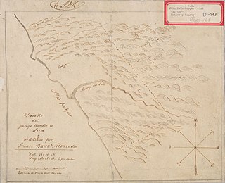
Rancho Saucos was a 22,212-acre (89.89 km2) Mexican land grant in present-day Tehama County, California given in 1844 by Governor Manuel Micheltorena to Robert H. Thomes. The name means "Ranch of the Elder trees". The grant extended along the west side of the Sacramento River from Elder Creek and Rancho Las Flores on the north to Thomes Creek on the south, and encompassed present-day Tehama.

Rancho Primer Cañon o Rio de Los Berrendos was a 26,637-acre (107.80 km2) Mexican land grant in present day Tehama County, California given in 1844 by Governor Manuel Micheltorena to Job Francis Dye. Rio de Los Berrendos means River of the Antelopes. The grant was on the east side of the Sacramento River and was bounded by Antelope Creek on the north and Rancho Rio de los Molinos and Dye Creek on the south.

<span class="mw-page-title-main">Rancho El Sur</span>

Rancho El Sur was a 8,949.06-acre (36.22 km2) Mexican land grant in present-day Monterey County, California, on the Big Sur coast given in 1834 by Governor José Figueroa to Juan Bautista Alvarado. The grant extended from the mouth of Little Sur River inland about 2.5 miles (4.0 km) over the coastal mountains and south along the coast past the mouth of the Big Sur River to Cooper's Point. In about 1892, the rancho land plus an additional 3,000 acres (1,200 ha) of resale homestead land was divided into two major parcels. The southern 4,800 acres (1,900 ha) became the Molera Ranch, later the foundation of Andrew Molera State Park. The northern 7,100 acres (2,900 ha) form the present-day El Sur Ranch.

<span class="mw-page-title-main">Red Bluff Diversion Dam</span> Dam in Tehama County, California

Red Bluff Diversion Dam is a disused irrigation diversion dam on the Sacramento River in Tehama County, California, United States, southeast of the city of Red Bluff. Until 2013, the dam provided irrigation water for two canals that serve 150,000 acres (61,000 ha) of farmland on the west side of the Sacramento Valley. The dam and canals are part of the Sacramento Canals Unit of the Central Valley Project, operated by the U.S. Bureau of Reclamation. In 2013, the dam was decommissioned and the river allowed to flow freely through the site in order to protect migrating fish. A pumping plant constructed a short distance upstream now supplies water to the canal system.

<span class="mw-page-title-main">Thomes Creek</span> River in California, United States

Thomes Creek is a major watercourse on the west side of the Sacramento Valley in Northern California. The creek originates in the Coast Ranges and flows east for about 62 miles (100 km) to join the Sacramento River, at a point about 7 miles (11 km) northeast of Corning in Tehama County.

<span class="mw-page-title-main">Red Bank Creek</span> River in California, United States

Red Bank Creek is a major stream in Tehama County, California, and a tributary of the Sacramento River. About 39 miles (63 km) long, it originates in the foothills of the Coast Ranges, near the boundary of the Mendocino National Forest, and flows east across the Sacramento Valley to join the Sacramento River near Red Bluff. Red Bank Creek, like the other streams draining this part of the western Sacramento Valley, is a highly seasonal stream that flows only during the winter and spring.

Beegum, also known as Bee Gum, is a defunct town which was located in an unincorporated area of Tehama and Shasta counties, in the U.S. state of California. In the early 1900s, it was a mining town in the Harrison Gulch mining district.

<span class="mw-page-title-main">Cold Fork, California</span> Unincorporated community in California, United States

Cold Fork, California is a historical crossroads and small settlement along Cold Fork Creek, a river tributary of the Cottonwood Creek in Tehama County, in the U.S. state of California, recorded on some historical maps as a district. The tributary, which is a fork of the South Fork of Cottonwood Creek, rises on the east slope of North Yolla Bolly Mountain, and flows generally east from there for about 22 miles (35 km) falling from an altitude of 6,000 feet (1,800 m) above sea level to 5,200 feet (1,600 m).

<span class="mw-page-title-main">Lowrey, California</span> Unincorporated community in California, United States

Lowrey's was a settlement in Tehama County, California that was named for George M. Lowrey and located on Elder Creek. What remains of it today are a ranch and a road named Lowrey Road.

Lyonsville in Tehama County, California was the site of the Lyonsville Mill, a major lumber operation which was once the largest sawmill in Northern California. It was located between the north and south forks of Antelope Creek, high above Hogsback Ridge. The mill served logging operations around Antelope Creek, and around it grew a town of the same name, with two saloons, a community hall, a general store, a post office, and machine and blacksmith shops. At its peak, there were more than 1000 people in the town.

<span class="mw-page-title-main">Red Bank, California</span> Rural area in Tehama Co., California, United States

Red Bank is an agricultural district in Tehama County, in the U.S. state of California. The district and nearby Red Bank Creek both take their names from Rancho Barranca Colorado. The red soil in question was said to be on the north bank of the creek. Red Bank was later the name of a post office in the district, previously named Eby, and of a school in the district.

Loybas Hill is an unincorporated community in Tehama County, in the U.S. state of California. According to the Geographic Names Information System, the community is on the west side of the Sacramento River and 4.6 miles southeast of the city of Corning.

<span class="mw-page-title-main">First Seat of Tehama County</span> Historical place in Tehama County, United States

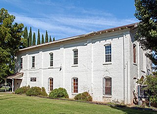
First Seat of Tehama County, First Tehama County Courthouse, is historical site in Tehama, California in Tehama County, California. The First Seat of Tehama County is a California Historical Landmark No. 183 listed on June 20, 1935. First Tehama County Courthouse was held in the a rented room inside the Union Hotel, later called the Heider House. Also meeting in the Union Hotel was the Tehama County's Board of Supervisors and other county officials. The Tehama County seat was in the Union Hotel from May 1856 to March 1857. In March 1857 the Tehama County seat moved to Red Bluff. The Heider House-Union Hotel was lost in a fire in 1908. The Heider House-Union Hotel was built on land what was part of the Robert Hasty Thomes (1817-1878) 22,212-acre Mexican land grant, Rancho Saucos.

References

  1. "Gerber church needs a piano". The Times-Standard. July 26, 2008. Retrieved November 7, 2023.
  2. 1 2 3 4 5 6 US 1988, p. 2173.
  3. "About Special Districts". El Camino Irrigation District. Retrieved November 8, 2023.
  4. "Filing deadline extended for some candidates in upcoming Tehama County General Election". Red Bluff Daily News. August 15, 2022. Retrieved November 8, 2023 via Newspapers.com.
  5. "Special district election filing period to open – Dozens of seats on north state governing boards to be up for grabs". Record Searchlight. Redding, California. July 17, 1991. Retrieved November 8, 2023 via Newspapers.com.
  6. 1 2 3 Rensch et al. 1966, p. 549.
  7. 1 2 3 Smith 1997, p. 37.
  8. 1 2 3 OU 1936.
  9. Hislop & Hughes 2007, p. 23.
  10. Hislop & Hughes 2007, p. 48.
  11. Thomes, Robert Hasty; Thomes, Robert Hasty; Thomes, Robert Hasty; United States District Court (California: Northern District) (eds.). Saucos (also called Rancho de Thomes) [Tehama County] Robert H. Thomes, Claimant. Case no. 85, Northern District of California. 1852-1856.{{cite book}}: CS1 maint: location (link)
  12. "Tehama County". The Sacramento Bee. June 30, 1902. p. 30. Retrieved November 3, 2023.
  13. CDO 1920a.
  14. CDO 1920b.
  15. 1 2 RBN 1923.
  16. RBTCDN 1928.
  17. "El Camino I. Dist. v. El Camino L. Corp". Justia. November 28, 1938. Retrieved November 8, 2023.
  18. Hislop & Hughes 2007, p. 21.
  19. "El Camino Grange Formed In Tehama". The Sacramento Bee . October 10, 1931. Retrieved November 8, 2023 via Newspapers.com.
  20. 1 2 US 1988, p. 2174.
  21. Donoghoe, Ellen M. (April 2003). "Delimiting Communities in the Pacific Northwest" (PDF). United States Department of Agriculture, Forest Service. Retrieved November 3, 2023.
  22. Wolf, Rebecca (January 18, 2007). "General plan proposal riles El Camino". The Times-Standard. Retrieved November 8, 2023.
  23. 1 2 California State Grange (2009). "Journal of Proceedings" (PDF). The California Granger. Retrieved November 7, 2023.
  24. "Grange Awards 50 Gallons of Gas". Red Bluff Daily News. July 12, 2008. Retrieved November 7, 2023.
  25. California State Grange (May 3, 2020). "Board of Directors Meeting Minutes" (PDF). The California Granger. Retrieved November 7, 2023.
  26. "Tehama County 4-H Clubs". Division of Agriculture and Natural Resources, University of California. Retrieved November 8, 2023.
  27. Barton, Jean (May 13, 2023). "Recapping the Tehama County Junior Livestock auction | Barton" . Retrieved November 8, 2023.
  28. Johnston, George (November 4, 2022). "Tehama County readies for election Tuesday". Red Bluff Daily News. Retrieved November 7, 2023.
  29. "Candlelight service planned for Sunday". Red Bluff Daily News. December 20, 2019. Retrieved November 8, 2023.
  30. 1 2 Tompson, Chip (June 18, 2014). "El Camino Cal Fire station to be staffed". The Times-Standard. Red Bluff Daily News. Retrieved November 8, 2023.
  31. "Station 9–El Camino". CAL FIRE/Tehama County Fire Department. Retrieved November 7, 2023.

Sources

  • Hislop, Donald L.; Hughes, Benjamin M. (2007). "Place Names" (PDF). Red Bluff, California. Archived from the original (PDF) on May 8, 2017. Retrieved March 25, 2018.
  • Smith, Dottie (1997). Ritter, Eric W. (ed.). Historical Overview of the Western Tehama County Foothills. Bureau of Land Management, Redding Resource Area.
  • United States Congress House of Representatives (1988). Energy and Water Development Appropriations for 1989: Testimony of members of Congress and other interested individuals and organizations. Vol. 8. United States Government Printing Office.
  • Rensch, Hero Eugene; Rensch, Ethel Grace; Hoover, Mildred Brooke; Abeloe, William N. (1966). "Tehama county". Historic Spots in California. Stanford University Press. ISBN   9780804700795.
  • "Simpson Finnell Dies At Newville home After Illness". Orland Unit. Orland, California. February 3, 1936.
  • "El Camino Rises from Old Elder Creek Ranch". The Corning Daily Observer. March 17, 1920. p. 1. Retrieved November 3, 2023.
  • "Recommends El Camino". The Corning Daily Observer. March 19, 1920. p. 1. Retrieved November 3, 2023.
  • "Eight Hundred Families for El Camino". Red Bluff News. March 16, 1923. p. 1. Retrieved November 3, 2023.
  • "El Camino Orchard Big Prune Producer". Red Bluff Tehama County Daily News. September 20, 1928. p. 1. Retrieved November 3, 2023.

Further reading