Red Bank, California

Last updated

Red Bank School in the early 20th century (Northeastern California Historical Photograph Collection, Cal State Chico) Red Bank School Northeastern California Historical Photograph Collection Digital Repository Meriam Library. California State University, Chico.jpg
Red Bank School in the early 20th century (Northeastern California Historical Photograph Collection, Cal State Chico)
Location of Red Bank on 1915 map of road network surrounding Red Bluff 1915 map of road network surrounding Red Bluff.jpg
Location of Red Bank on 1915 map of road network surrounding Red Bluff
Ranchos of Tehama County Mexican land grants - Ranchos of Tehama County California - Bureau of Land Management - 1997.jpg
Ranchos of Tehama County
Diseno of Rancho de la Baranca Colorada in Tehama County c. 1844 Diseno del Rancho de la Baranca Colorada Tehama Co.jpg
Diseño of Rancho de la Baranca Colorada in Tehama County c.1844

Red Bank (also Redbank) is an agricultural district in Tehama County, in the U.S. state of California. [1] The district and nearby Red Bank Creek both take their names from Rancho Barranca Colorado (Red Bank in Spanish). [2] [1] [3] The red soil in question was said to be on the north bank of the creek. [4] Red Bank was later the name of a post office in the district, previously named Eby, and of a school in the district. [5] [1]

Contents

History

A land granted dated December 24, 1844, refers to the Barranca Colorado "red ravine". [6] Subdivision of the Barranca ranch began after William Ide's death in 1861. [7] According to a newspaper account of 1933, "Out of this ranch has been carved the Orchard Park settlement, the fine farms of Butte Tyler and Joe Casale, beside several other smaller holdings and there yet remains fragment of the original grant in the Ide estate. [4]

Red Bank School

The school was the Red Bank School, whose location in the district varied over the years, but in 1891 was just east of the road that connects Lowrey Road with Red Bank Road. [1] It finally closed in 1962. [1] Red Bank School was one of nine one-room schoolhouses in Tehama County in the early 20th century. [8] A former student described the school as a white-shingled building near the creek; inside was a potbelly stove "and a wash basin to hold water from the well, which students used dippers to drink from". [8]

The Meriam Library at Cal State Chico has photographs of the one-room school. [9] Tehama County residents Opal and Archie Kissee photographed almost all the Tehama County schoolhouses, including Red Bank, [10] with color slide film in the 1960s. [11]

Post office

A post office called Redbank was established in 1904, with postmaster Charles S. Beall, and remained in operation until 1918 when it was moved to Red Bluff. [1] [12] [13] (Beall, or Bell, had a home in Red Bank that burned to the ground in a 1909 fire—the only item saved was a sewing machine.) [14]

The post office had originally been the Colyear (also Colyer) post office, established 10 miles (16 km) southwest of Red Bluff in July 1889, moved 5 miles (8.0 km) west to Eby (and renamed) in April 1894, and finally moving again to Red Bank in 1904. [15] [5] The exact location of Eby post office, named for landowner Jackson Eby, is not clear from historical sources, as maps are either vague or known to be inaccurate. [5] The best source is the Red Bluff Daily News of 19011902 which places it in the centre of the school district, 15.5 miles (24.9 km) west of Red Bluff. [5]

Other organizations

In 1909 a Red Bluff Chamber of Commerce brochure marketing Tehama County described Red Bank as one of the "smaller centers" of the county Smaller centers of Tehama County.jpg
In 1909 a Red Bluff Chamber of Commerce brochure marketing Tehama County described Red Bank as one of the "smaller centers" of the county

In April 1892, a Methodist preacher named J. E. Ray started giving sermons at the school house in Red Bank, and at Union Church in Lowrey. [16]

From 1917 to 1929, the Red Bank branch of the Tehama County public library was in the home of Mrs. C. S. Bell. [17] [18]

The Red Bank Farm Center supported a community baseball team in the 1920s. [19]

The Red Bank 4-H Club restored the Red Bank Cemetery in 1977, including installing a "new archway" that was donated for the "old site". [20] The inactive Red Bank Cemetery is located on Red Bank Road and has six known burials, dating from the 1910s to the 1930s. [21]

Population

Based on 1990 census data, the United States Department of Agriculture found that the Red Bank "block group" had a population of 1,155. [22]

Agriculture and development

"For sale: Good 935 acre farm in Red Bank Valley..." (Healdsburg Tribune, 1925) For sale - Good 935 acre farm.jpg
"For sale: Good 935 acre farm in Red Bank Valley..." (Healdsburg Tribune, 1925)

The western watershed of Tehama county is predominately a farming, ranching, or lumbering area, with an average population density of five people per square mile as of 2006. [23] Major crops produced by west Tehama county farms are typically grain, pasture grass, orchard crops, and/or sheep or cows. [23] Milk products from the cows might have been sold over the mountains to Tomales Bay Creamery. [8] One son of a sheep rancher recalled that their Red Bank farm was first hooked up to a party line telephone service with three other farms in the late 1930s. [8] An alfalfa-hog-sheep-cow farmer who moved to Red Bank in 1942 recalled that she and her husband bought land that had already been cultivated for 50 years, but their place did not have an irrigation well until they sank one, nor electricity until 1945. [24]

A telephone line between Red Bank and Red Bluff was connected in 1911, along with a branch line that extended 3 miles (4.8 km) northwest of the Red Bank post office. [25]

In 1977, county planning commissioners denied a developer's request that some land in Red Bank be reclassified from agricultural to agricultural-transitional, which would have allowed for partitioning into smaller lot sizes. [26]

Red Bank Fire

The Red Bank Fire was ignited by a lightning strike on September 5, 2019. [27] The fire burned 8,838 acres (3,577 ha) of oak woods and brushland west of Red Bluff that is used mostly for cattle range, [28] Firefighting in the "rural and rugged" area was hampered by lack of roads. [29] The area at risk was said to have low population density and most structures were "seasonal cabins and ranches". [29] The fire was extinguished on September 13. [27]

Related Research Articles

<span class="mw-page-title-main">Tehama County, California</span> County in California, United States

Tehama County is a county located in the northern part of the U.S. state of California. As of the 2020 census, the population was 65,829. The county seat and largest city is Red Bluff.

<span class="mw-page-title-main">Red Bluff, California</span> City in California, United States

Red Bluff is a city in and the county seat of Tehama County, California, United States. The population was 14,710 at the 2020 census, up from 14,076 at the 2010 census.

<span class="mw-page-title-main">William B. Ide</span> American pioneer and politician (1796-1852)

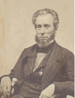
William Brown Ide was an American pioneer who headed the short-lived California Republic in 1846.

<span class="mw-page-title-main">Josiah Belden</span> American politician

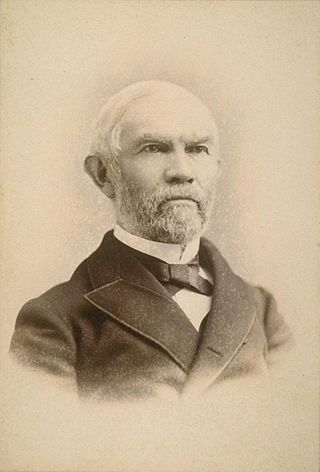
Josiah Belden, known in Spanish as Josías Belden, was a Californian politician and trader. He was born in Connecticut, eventually emigrating to Alta California. In California, he became a Mexican citizen, a prominent trader, and a rancho grantee.

<span class="mw-page-title-main">Bridgeville, California</span> Unincorporated community in California, United States

Bridgeville is an unincorporated community in Humboldt County, California. It is located 12 miles (19 km) north-northeast of Weott, at an elevation of 636 feet. Bridgeville is 260 mi (420 km) north of San Francisco, with a population of about 25.


The Daily News is a morning newspaper in Red Bluff, California and Tehama County, California. It was founded in November 1885 and is now owned by Digital First Media, formerly MediaNews Group. MediaNews Group acquired it from Donrey in 1999. The Daily News also publishes supplements to the publications: Tehama The Magazine, Red Bluff Today, Corning Today, Tehama County Visitor's Guide, and the annual Best of Tehama County readers choice awards.. The newspaper has a paid circulation of approximately 7,500 and is published Tuesday through Saturday.

<span class="mw-page-title-main">William B. Ide Adobe State Historic Park</span> Historic site in California, United States

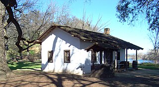
William B. Ide Adobe State Historic Park is a California State Historic Park located on the west bank of the Sacramento River, a mile north of Red Bluff in Tehama County, California. Although it was initially believed that Ide built the adobe, research has shown that he never lived in the place that bears his name today. Nevertheless, the State of California decided to keep the name of the park in recognition of Ide's role in California history.

Kirkwood was a town in Tehama County, California, which survives only as the Kirkwood school district and Kirkwood cemetery today. It once had a post office and school, and a railway station. The town was not named Kirkwood until the railway arrived; the school originally having been named Montgomery School and the property owned by postmaster William Wallace Watkins. The town grew up around the railway station.

<span class="mw-page-title-main">Rohnerville, California</span> Unincorporated community in California, United States

Rohnerville is an unincorporated community in Humboldt County, California. It is located 2.25 miles (3.6 km) southeast of Fortuna, at an elevation of 197 feet (60 m).

<span class="mw-page-title-main">Rancho Barranca Colorado</span> Mexican land grant in California

Rancho Barranca Colorado was a 17,707-acre (71.66 km2) Mexican land grant in present-day Tehama County, California given in 1844 by Governor Manuel Micheltorena to Josiah Belden. The name means "Ranch of the Red Bluffs". The grant was on the west bank of the Sacramento River and bounded Red Bank Creek on the north, and Coyote Creek and Rancho Las Flores on the south. The grant was about 2 miles (3.2 km) south of present-day Red Bluff.

<span class="mw-page-title-main">Rancho Saucos</span> Mexican land grant in California

Rancho Saucos was a 22,212-acre (89.89 km2) Mexican land grant in present-day Tehama County, California given in 1844 by Governor Manuel Micheltorena to Robert H. Thomes. The name means "Ranch of the Elder trees". The grant extended along the west side of the Sacramento River from Elder Creek and Rancho Las Flores on the north to Thomes Creek on the south, and encompassed present-day Tehama.

<span class="mw-page-title-main">Red Bank Creek</span> River in California, United States

Red Bank Creek is a major stream in Tehama County, California, and a tributary of the Sacramento River. About 39 miles (63 km) long, it originates in the foothills of the Coast Ranges, near the boundary of the Mendocino National Forest, and flows east across the Sacramento Valley to join the Sacramento River near Red Bluff. Red Bank Creek, like the other streams draining this part of the western Sacramento Valley, is a highly seasonal stream that flows only during the winter and spring.

Beegum, also known as Bee Gum, is a defunct town which was located in an unincorporated area of Tehama and Shasta counties, in the U.S. state of California. In the early 1900s, it was a mining town in the Harrison Gulch mining district.

<span class="mw-page-title-main">Cold Fork, California</span> Unincorporated community in California, United States

Cold Fork, California is a historical crossroads and small settlement along Cold Fork Creek, a river tributary of the Cottonwood Creek in Tehama County, in the U.S. state of California, recorded on some historical maps as a district. The tributary, which is a fork of the South Fork of Cottonwood Creek, rises on the east slope of North Yolla Bolly Mountain, and flows generally east from there for about 22 miles (35 km) falling from an altitude of 6,000 feet (1,800 m) above sea level to 5,200 feet (1,600 m).

<span class="mw-page-title-main">El Camino, California</span> Special district in California, United States

El Camino is a rural community and irrigation district near Gerber in Tehama County, in the U.S. state of California. As a special district, the El Camino Irrigation District is owned by local residents who govern it through locally elected board members.

Henleyville is an unincorporated community in Tehama County, in the U.S. state of California.

<span class="mw-page-title-main">Lowrey, California</span> Unincorporated community in California, United States

Lowrey's was a settlement in Tehama County, California that was named for George M. Lowrey and located on Elder Creek. What remains of it today are a ranch and a road named Lowrey Road.

Lyonsville in Tehama County, California was the site of the Lyonsville Mill, a major lumber operation which was once the largest sawmill in Northern California. It was located between the north and south forks of Antelope Creek, high above Hogsback Ridge. The mill served logging operations around Antelope Creek, and around it grew a town of the same name, with two saloons, a community hall, a general store, a post office, and machine and blacksmith shops. At its peak, there were more than 1000 people in the town.

Loybas Hill is an unincorporated community in Tehama County, in the U.S. state of California. According to the Geographic Names Information System, the community is on the west side of the Sacramento River and 4.6 miles southeast of the city of Corning.

The Red Bank Fire was one of a series of wildfires in Tehama County, California, 25 miles west of Red Bluff. The Red Bank area fire was ignited from a series lightning strikes and erupted out of control on Thursday, September 5, 2019. The blaze, along with the South and Henthrone fires, is burning in a remote location, 30 miles south of Redding, California. The fire was contained on September 13 at 8,838 acres (36 km2). Two structures were destroyed.

References

  1. 1 2 3 4 5 6 Hislop & Hughes 2007, p. 45.
  2. Smith 1997, p. 10.
  3. RBN 1899, p. 3.
  4. 1 2 RBTCDN 1935, p. 27.
  5. 1 2 3 4 Hislop & Hughes 2007, p. 20.
  6. Gudde, Erwin Gustav (1998). California Place Names (4th, revised and enlarged ed.). Berkeley and Los Angeles: University of California Press. p. 312. ISBN   0-520-21316-5.
  7. Ide 1861.
  8. 1 2 3 4 Hamburg, Laura (June 14, 1998). "Longtime Californ': Last month, 300 former students from the little one-room schoolhouses of Tehama County—north up the highway from Sacramento—got together to dance and remember what, for many, really were good old days". San Francisco Chronicle. Retrieved 2023-11-04.
  9. Chico.
  10. Kissee, Opal, Red Bank School , retrieved 2023-11-04
  11. "Dairyville Family Has Interesting Collection of Various Antiques". Red Bluff Tehama County Daily News. January 5, 1966. p. 12. Retrieved 2023-11-04.
  12. Helbock & Williams 1988, p. 34.
  13. USPS 1909, p. 53.
  14. RBN 1909, p. 3.
  15. Hislop & Hughes 2007, p. 16.
  16. Chase, Don M. (1945). Pioneers: Sketches of pioneer days in Shasta, Tehama, Trinity, and Siskiyou Counties with emphasis on the beginnings of religious organizations. p. 21.
  17. RBN 1926, p. 2.
  18. RBTCDN 1929.
  19. RBTCDN 1928.
  20. "4H Happenings - Red Bluff Daily News Archives, Nov 29, 1977, p. 2". NewspaperArchive.com. November 29, 1977. Retrieved 2023-11-05.
  21. "Tehama County Cemeteries and Graves Photos & Listings". www.tcghsoc.org. Retrieved 2023-11-05.
  22. Donoghoe, Ellen M. (April 2003). "Delimiting Communities in the Pacific Northwest" (PDF). United States Department of Agriculture, Forest Service. Retrieved 2023-11-03.
  23. 1 2 VESTRA Resources, Inc. (April 2006). Tehama West Watershed Assessment Executive Summary (PDF) (Report). Redding, California: Tehama County Resource Conservation District. pp. 1 (economy, population density). Retrieved 2023-11-04.
  24. "Letter to the Editor (Lily T. Fitzgerald): Pioneers of Red Bank Area at Red Bank Since 1942 - Red Bluff Daily News Newspaper Archives, Jan 4, 1971, p. 7". NewspaperArchive.com. January 4, 1971. Retrieved 2023-11-05.
  25. "Sacramento Daily Union 2 November 1911 — California Digital Newspaper Collection". cdnc.ucr.edu. Retrieved 2023-11-05.
  26. "Red Bank Rezone Nixed by Jeff Bauer Red Bluff Daily News Archives, Dec 17, 1977, p. 1". NewspaperArchive.com. December 17, 1977. Retrieved 2023-11-05.
  27. 1 2 "Red Bank Fire now fully contained". Record Searchlight. September 15, 2019. pp. C2. Retrieved 2023-11-04.
  28. Cosgrove, Jaclyn (September 6, 2019). "Northern California fire reaches 6,500 acres, 5% containment". Los Angeles Times. Retrieved 2023-11-05.
  29. 1 2 "Crews battling blaze west of Red Bluff; evacuations ordered". Record Searchlight. September 6, 2019. pp. A1. Retrieved 2023-11-04.

Sources

40°05′58″N122°26′43″W / 40.09944°N 122.44528°W / 40.09944; -122.44528