
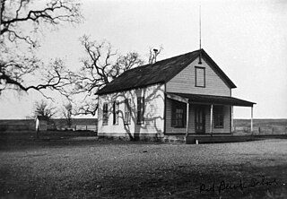
Lowrey's was a settlement in Tehama County, California that was named for George M. Lowrey and located on Elder Creek. [1] What remains of it today are a ranch and a road named Lowrey Road. [1]
Lowrey's was a settlement in Tehama County, California that was named for George M. Lowrey and located on Elder Creek. [1] What remains of it today are a ranch and a road named Lowrey Road. [1]
George Malay Lowrey came to California in 1849. [1] [2] He had been born in Montgomery County, Ohio on 1826-10-26; the fifth child of James Lowrey, a miller from Kentucky, and Nancy Lowrey (née Stoker) from Virginia. [2] Having left school at 17, he had worked in the Mount Savage iron works, and as a carpenter for 3 years, both in Maryland. [2]
He arrived at Sacramento on 1849-08-13, moved to Dry Diggings shortly thereafter, and in 1850 built himself and ran a hotel between Sacramento and Nevada City. [2] He gave up the hotel after two years and went into teaming, going back to Ohio and then coming to California again in 1863. [2] He was in the cattle industry with a business partner in Solano County for eight years from 1857, and also raised sheep. [2]
He married Sarah Morrow Foster from Belfast (born 1826-03-21, and daughter of a farmer, cattleman, and drover) in Calvary Presbyterian Church in San Francisco on 1865-08-29. [3] They were to have four daughters and three sons together. [3]
In 1870, Lowrey and a business partner bought 1,040 acres (420 ha) of land in Tehama, which he was to expand with additional purchases over time to a peak 4,000 acres (1,600 ha), which they used for sheep farming. [2] He bought out his partner in 1874, and sold 7000 head of sheep and 2,825 acres (1,143 ha) of his ranchland to avoid bankruptcy, diversifying into cattle and hogs. [2]
His home was the local post office, established in 1888 with himself as the postmaster. [4] [2] The application claimed the post office would serve a settlement of 425 people. [5] The location was likely the south bank of the North Fork of Elder Creek. [5] Its name changed to Lowrey in 1898, and it closed in October 1917 with mail thenceforward being handled at Red Bank. [4] [1]
The Lowrey school, which he also helped to organize, was established in 1873, and closed in 1943. [1] [2] He was the director of the school district and supported the local Union Church. [2]
His daughter Katie became the postmaster at Tehama. [3]
There were three major chromite mines to the west of Lowrey's in the North Elder Creek area, the Grau Mine, the Kleinsorge Mine, and the Noble Electric Mine. [1] [6] [7] The Grau Mine dates from 1893, the Noble Electric from 1886, and the Kleinsorge from 1916. [8] One of the earliest mines lasted from 1890 to 1899, and only produced 500 tons (450 t) over its lifetime. [6]
The Basler Mining and Development Company consolidated many of the mining claims in the area in the early 1900s. [6] The Kleinsorge was on the mountainside and had a service road down to Lowrey and an aerial tramway for transporting ore down. [8] The Noble Electric, which only produced comparatively little ore, had a service road built in 1919 and did not have its own mill. [8]

Tehama County is a county located in the northern part of the U.S. state of California. As of the 2020 census, the population was 65,829. The county seat and largest city is Red Bluff.

Lassen National Forest is a United States national forest of 1,700 square miles (4,300 km2) in northeastern California. It is named after pioneer Peter Lassen, who mined, ranched and promoted the area to emigrant parties in the 1850s.
The community of San Antonio Valley, also called San Antonio or San Antone, is located along the Diablo Range in eastern Santa Clara County, California. The locale is bordered by Alameda County to the north and Stanislaus County to the east. The sparsely populated area is located at the junction of San Antonio Valley Road, Mines Road, and Del Puerto Canyon Road. The area includes the San Antonio Valley Ecological Reserve, a 3,282 acre nature preserve created by a Nature Conservancy purchase of land from local rancher, Keith Hurner, and known for its herd of tule elk.


The Yolla Bolly–Middle Eel Wilderness is a federally designated wilderness area in the Yolla Bolly Range of the southern Klamath Mountains and the Inner Northern California Coast Ranges, in Northern California.
Chicago Park is a residential and unincorporated historic agricultural community in Nevada County, California. It is located along Highway 174, with its center at the intersection of Mt. Olive Road. The neighborhood gets its name from its founding residents, who came from Chicago to California in the late 1800s to grow fruit, which was often shipped back to Illinois for consumption. Chicago Park is about 9 miles southeast of Grass Valley and about 3 miles north of Colfax.
Rancho Las Flores was a 13,316-acre (53.89 km2) Mexican land grant in present-day Tehama County, California given in 1844 by Governor Manuel Micheltorena to William Chard. The name means "ranch of the flowers". The grant was on the west side of the Sacramento River and was bounded by Rancho Barranca Colorado and Coyote Creek on the north and by Rancho Saucos and Elder Creek on the south, and encompassed present-day Gerber and Proberta.

Rancho Saucos was a 22,212-acre (89.89 km2) Mexican land grant in present-day Tehama County, California given in 1844 by Governor Manuel Micheltorena to Robert H. Thomes. The name means "Ranch of the Elder trees". The grant extended along the west side of the Sacramento River from Elder Creek and Rancho Las Flores on the north to Thomes Creek on the south, and encompassed present-day Tehama.
Rancho Primer Cañon o Rio de Los Berrendos was a 26,637-acre (107.80 km2) Mexican land grant in present day Tehama County, California given in 1844 by Governor Manuel Micheltorena to Job Francis Dye. Rio de Los Berrendos means River of the Antelopes. The grant was on the east side of the Sacramento River and was bounded by Antelope Creek on the north and Rancho Rio de los Molinos and Dye Creek on the south.
Rancho Bosquejo was a 22,206-acre (89.86 km2) Mexican land grant in present-day Tehama County, California given in 1844 by Governor Manuel Micheltorena to Peter Lassen. The name means "Wooded Ranch" in Spanish. The grant extended along the east bank of the Sacramento River south of Rancho Rio de los Molinos and Toomes Creek, and encompassed present day Vina on Deer Creek.

Stony Creek is a 73.5-mile (118.3 km)-long tributary of the Sacramento River in Northern California. It drains a watershed of more than 700 square miles (1,800 km2) on the west side of the Sacramento Valley in Glenn, Colusa, Lake and Tehama Counties.

Elmer Scott Rigdon was a member of the California State Senate from Cambria, California. He was the key proponent for building the Carmel-San Simeon Highway along the Big Sur coast. He was a member of the California Senate Committee on Roads and Highways and during World War I promoted the military necessity of defending California's coast. He persuaded the legislature to approve the project. In 1919, the legislature approved submission of a bond measure to voters.
Beegum, also known as Bee Gum, is a defunct town which was located in an unincorporated area of Tehama and Shasta counties, in the U.S. state of California. In the early 1900s, it was a mining town in the Harrison Gulch mining district.

Cold Fork, California is a historical crossroads and small settlement along Cold Fork Creek, a river tributary of the Cottonwood Creek in Tehama County, in the U.S. state of California, recorded on some historical maps as a district. The tributary, which is a fork of the South Fork of Cottonwood Creek, rises on the east slope of North Yolla Bolly Mountain, and flows generally east from there for about 22 miles (35 km) falling from an altitude of 6,000 feet (1,800 m) above sea level to 5,200 feet (1,600 m).

El Camino is a rural community and irrigation district near Gerber in Tehama County, in the U.S. state of California. As a special district, the El Camino Irrigation District is owned by local residents who govern it through locally elected board members.
Red Bank is an agricultural district in Tehama County, in the U.S. state of California. The district and nearby Red Bank Creek both take their names from Rancho Barranca Colorado. The red soil in question was said to be on the north bank of the creek. Red Bank was later the name of a post office in the district, previously named Eby, and of a school in the district.
Loybas Hill is an unincorporated community in Tehama County, in the U.S. state of California. According to the Geographic Names Information System, the community is on the west side of the Sacramento River and 4.6 miles southeast of the city of Corning.
Harmon Augustus Good led a life as an “Indian hunter.” His closest friends in California addressed him as Hiram or simply "Hi" Good. On May 4, 1870, at the age of 34 he was killed by members of Ishi’s Yahi band, who, especially would have had the motive. Good became a ruthless leader of volunteer vigilante parties, who battled the diverse mix of Native Americans in northern California during the Indian war years, 1857 to 1865. Many locals proclaimed him the “Boone of the Sierra.” According to Butte County historian George Mansfield, “Good, in particular, was held in the most bitter hatred among the Indians.” In 1923 fellow Indian hunter Sim Moak recalled that “at one time Good had forty scalps hanging in the poplar tree by his house” and described Good adorning the outseam of his pants with scalps: “you can imagine a great tall man with a string of scalps from his belt to his ankle”.
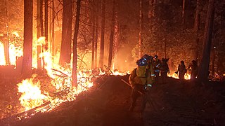
The Zogg Fire was a wildfire that burned 56,338 acres (22,799 ha) in southwestern Shasta County and northwestern Tehama County, which are both in California, in the United States, as part of the severe 2020 California wildfire season. The fire was first reported on September 27, 2020 and was not fully contained until October 13, 2020, by which time it had destroyed much of the communities of Igo and Ono, killing four people and destroying 204 buildings.
{{cite book}}: CS1 maint: location missing publisher (link)Municipalities and communities of Tehama County, California, United States | ||
|---|---|---|
| Cities |  | |
| CDPs | ||
| Unincorporated communities | ||
| Historic communities | ||
| Footnotes | ‡This populated place also has portions in an adjacent county or counties | |
40°00′50″N122°33′12″W / 40.01389°N 122.55333°W
| | This Tehama County, California-related article is a stub. You can help Wikipedia by expanding it. |