Boothbay Harbor (CDP), Maine

Last updated

Boothbay Harbor, Maine
Lincoln County Maine incorporated and unincorporated areas Boothbay Harbor (CDP) highlighted.svg
Location in Lincoln County and the state of Maine
Coordinates: 43°51′10″N69°37′27″W / 43.85278°N 69.62417°W / 43.85278; -69.62417
CountryUnited States
State Maine
County Lincoln
Town Boothbay Harbor
Area
[1]
  Total0.85 sq mi (2.20 km2)
  Land0.85 sq mi (2.20 km2)
  Water0.00 sq mi (0.00 km2)
Elevation
43 ft (13 m)
Population
 (2020)
  Total872
  Density1,028.30/sq mi (397.18/km2)
Time zone UTC-5 (Eastern (EST))
  Summer (DST) UTC-4 (EDT)
ZIP codes
04538, 04570
Area code 207
FIPS code 23-06085
GNIS feature ID0562757
Website boothbayharbor.org

Boothbay Harbor is a census-designated place (CDP) comprising the densely populated center of the town of Boothbay Harbor in Lincoln County, Maine, United States. The population was 1,086 at the 2010 census, [2] down from 1,237 at the 2000 census.

Contents

Geography

The Boothbay Harbor CDP is located in the east-central part of the town of Boothbay Harbor at 43°51′10″N69°37′27″W / 43.85278°N 69.62417°W / 43.85278; -69.62417 (43.852819, −69.624271), [3] in southwestern Lincoln County. The CDP is bordered to the south by the water body of Boothbay Harbor, an inlet off the Gulf of Maine, and to the southwest by Mill Cove, an arm of Boothbay Harbor. To the northwest the CDP is bordered by the inlet stream of Mill Cove, running northeast to Maine State Route 27. To the northeast, the CDP is bordered by Maine State Route 96 (Ocean Point Road) and to the east it extends to Meadow Brook. Lobster Cove Road forms the southeasternmost extent of the CDP. [4] Via Route 27, Boothbay Harbor is 13 miles (21 km) south of Wiscasset.

According to the United States Census Bureau, the CDP has a total area of 0.85 square miles (2.2 km2), all land. [5]

Demographics

Historical population
CensusPop.Note
2020 872
U.S. Decennial Census [6]

As of the 2000 census, [7] there were 1,237 people, 586 households, and 309 families residing in the CDP. The population density was 1,432.0 inhabitants per square mile (552.9/km2). There were 800 housing units at an average density of 926.1 per square mile (357.6/km2). The racial makeup of the CDP was 97.49% White, 0.16% Black or African American, 0.57% Native American, 0.81% Asian, 0.49% from other races, and 0.49% from two or more races. Hispanic or Latino of any race were 0.57% of the population.

There were 586 households, out of which 21.7% had children under the age of 18 living with them, 41.8% were married couples living together, 9.0% had a female householder with no husband present, and 47.1% were non-families. 39.4% of all households were made up of individuals, and 20.0% had someone living alone who was 65 years of age or older. The average household size was 2.04 and the average family size was 2.74.

In the CDP, the population was spread out, with 17.5% under the age of 18, 6.5% from 18 to 24, 24.3% from 25 to 44, 26.6% from 45 to 64, and 25.0% who were 65 years of age or older. The median age was 46 years. For every 100 females, there were 82.4 males. For every 100 females age 18 and over, there were 79.3 males.

The median income for a household in the CDP was $31,201, and the median income for a family was $38,125. Males had a median income of $27,000 versus $15,658 for females. The per capita income for the CDP was $18,133. About 8.5% of families and 13.7% of the population were below the poverty line, including 22.4% of those under age 18 and 10.6% of those age 65 or over.

Related Research Articles

<span class="mw-page-title-main">Lincoln County, Maine</span> County in Maine, United States

Lincoln County is a county located in the U.S. state of Maine. As of the 2020 census, the population was 35,237. Its seat is Wiscasset. The county was founded in 1760 by the Massachusetts General Court from a portion of York County, Massachusetts and named after the English city Lincoln, the birthplace of Massachusetts Bay Provincial Governor Thomas Pownall.

<span class="mw-page-title-main">Waikapu, Hawaii</span> Census-designated place in Hawaii, United States

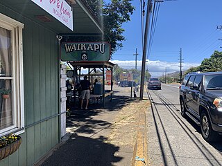
Waikapu is a census-designated place (CDP) in Maui County, Hawaii, United States. The population was 3,437 at the 2020 census.

<span class="mw-page-title-main">Brunswick Station, Maine</span> Census-designated place in Maine, United States

Brunswick Station was a census-designated place (CDP) within the town of Brunswick in Cumberland County, Maine, United States. The population was 578 at the 2010 census. It consists of an area that was part of the former Naval Air Station Brunswick and was part of the Portland–South Portland–Biddeford, Maine Metropolitan Statistical Area. The 2020 census shows it as part of the Brunswick CDP.

<span class="mw-page-title-main">Falmouth Foreside, Maine</span> Census-designated place in Maine, United States

Falmouth Foreside is a census-designated place (CDP) within the town of Falmouth in Cumberland County, Maine, in the United States. As of the 2010 census, the CDP population was 1,511. It is part of the Portland–South Portland–Biddeford, Maine Metropolitan Statistical Area.

<span class="mw-page-title-main">Boothbay, Maine</span> Town in Maine, United States

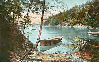
Boothbay is a town in Lincoln County, Maine, United States. The population was 3,003 at the 2020 census. It includes the villages of Back Narrows, Dover, East Boothbay, Linekin, Oak Hill, Ocean Point, Spruce Shores, and Trevett. The Boothbay region is a center of summer tourist activity, and a significant part of its population does not live there year-round. Five shipyards are located in the town, the largest of which is Washburn & Doughty.

<span class="mw-page-title-main">Southport, Maine</span> Town in the state of Maine, United States

Southport is a town and archipelago in Lincoln County, Maine, United States. The population was 622 at the 2020 census. It includes the villages of Capitol Island, Hendricks Harbor, Newagen, Pine Cliff, Squirrel Island, and West Southport. The majority of the town's residents live on its main island, Southport Island.

Richmond is a census-designated place (CDP) in the town of Richmond in Sagadahoc County, Maine. The population was 1,864 at the 2000 census. It is part of the Portland–South Portland–Biddeford, Maine Metropolitan Statistical Area.

<span class="mw-page-title-main">Kennebunkport (CDP), Maine</span> Census-designated place in Maine, United States

Kennebunkport is a census-designated place (CDP) consisting of the central village in the town of Kennebunkport in York County, Maine, United States. The population was 1,238 at the 2010 census, out of a total town population of 3,474. It is part of the Portland–South Portland–Biddeford, Maine Metropolitan Statistical Area.

<span class="mw-page-title-main">Brunswick (CDP), Maine</span> Census-designated place in Maine, United States

Brunswick is a census-designated place (CDP) in the town of Brunswick in Cumberland County, Maine, United States. The population was 15,175 at the 2010 census. It is part of the Portland–South Portland–Biddeford, Maine Metropolitan Statistical Area.

<span class="mw-page-title-main">Yarmouth (CDP), Maine</span> Census-designated place in Maine, United States

Yarmouth is a census-designated place (CDP) in the town of Yarmouth in Cumberland County, Maine, United States. The population was 5,869 at the 2010 census. It is part of the Portland–South Portland–Biddeford, Maine Metropolitan Statistical Area.

Bar Harbor is a census-designated place (CDP) in the town of Bar Harbor in Hancock County, Maine, United States. The CDP population was 2,552 at the 2010 census, out of a population of 5,235 in the town of Bar Harbor as a whole.

<span class="mw-page-title-main">Oakland (CDP), Maine</span> Census-designated place in Maine, United States

Oakland is a census-designated place (CDP) comprising the main population center in the town of Oakland in Kennebec County, Maine, United States. The population was 2,602 at the 2010 census, out of 6,240 in the entire town of Oakland.

<span class="mw-page-title-main">Camden (CDP), Maine</span> Census-designated place in Maine, United States

Camden is a census-designated place (CDP) comprising the main village in the town of Camden in Knox County, Maine, United States. The population was 3,570 at the 2010 census, out of 4,850 in the entire town of Camden.

<span class="mw-page-title-main">Thomaston (CDP), Maine</span> Census-designated place in Maine, United States

Thomaston is a census-designated place (CDP) comprising the main village in the town of Thomaston in Knox County, Maine, United States. The population was 1,875 at the 2010 census, out of 2,781 in the town of Thomaston as a whole.

<span class="mw-page-title-main">Boothbay Harbor, Maine</span> Town in Maine, United States

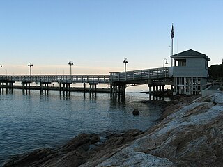
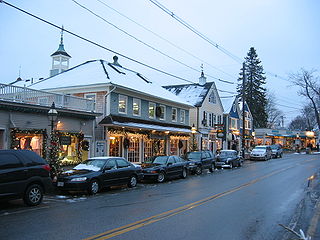
Boothbay Harbor is a town in Lincoln County, Maine, United States. The population was 2,027 at the 2020 census. It includes the villages of Bayville, Sprucewold, and West Boothbay Harbor. During summer months, the entire Boothbay Harbor region is a popular yachting and tourist destination. The ZIP Code is 04538, and the community is served by the 633 telephone exchange in area code 207.

<span class="mw-page-title-main">Waldoboro (CDP), Maine</span> Census-designated place in Maine, United States

Waldoboro is a census-designated place (CDP) comprising the central village in the town of Waldoboro in Lincoln County, Maine, United States. The population was 1,300 at the 2020 census, out of 5,075 people in the entire town of Waldoboro.

<span class="mw-page-title-main">Wiscasset (CDP), Maine</span> Census-designated place in Maine, United States

Wiscasset is a census-designated place (CDP) comprising the primary settlement in the town of Wiscasset in Lincoln County, Maine, United States. The population was 1,232 at the 2020 census, out of 3,732 people in the entire town. Wiscasset is the county seat of Lincoln County.

Dexter is a census-designated place (CDP) comprising the main settlement within the town of Dexter in Penobscot County, Maine, United States. The population of the CDP was 2,158 at the 2010 census.

Topsham is a census-designated place (CDP) in the town of Topsham in Sagadahoc County, Maine, United States. The population was 6,271 at the 2000 census. It is part of the Portland–South Portland–Biddeford, Maine Metropolitan Statistical Area.

<span class="mw-page-title-main">Fairfield (CDP), Maine</span> CDP in Maine, United States

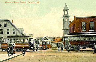
Fairfield is a census-designated place (CDP) in the town of Fairfield in Somerset County, Maine, United States. The population was 2,569 at the 2000 census.

References

  1. "2020 U.S. Gazetteer Files". United States Census Bureau. Retrieved April 8, 2022.
  2. "Total Population: 2010 Census DEC Summary File 1 (P1), Boothbay Harbor CDP, Maine". data.census.gov. U.S. Census Bureau. Retrieved March 3, 2020.
  3. "US Gazetteer files: 2010, 2000, and 1990". United States Census Bureau. February 12, 2011. Retrieved April 23, 2011.
  4. "TIGERweb: Boothbay Harbor CDP, Maine". U.S. Census Bureau, Geography Division. Retrieved March 3, 2020.
  5. "U.S. Gazetteer Files: 2019: Places: Maine". U.S. Census Bureau Geography Division. Retrieved March 3, 2020.
  6. "Census of Population and Housing". Census.gov. Retrieved June 4, 2016.
  7. "U.S. Census website". United States Census Bureau . Retrieved 2008-01-31.