
Lincoln County is a county located in the U.S. state of Maine. As of the 2020 census, the population was 35,237. Its seat is Wiscasset. The county was founded in 1760 by the Massachusetts General Court from a portion of York County, Massachusetts and named after the English city Lincoln, the birthplace of Massachusetts Bay Provincial Governor Thomas Pownall.

Sunny Isles Beach is a city located on a barrier island in northeast Miami-Dade County, Florida, United States. The city is part of the Miami metropolitan area of South Florida, and is bounded by the Atlantic Ocean on the east and the Intracoastal Waterway on the west. As of the 2020 census, it had a population of 22,342.
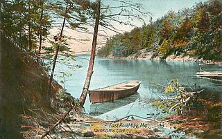
Boothbay is a town in Lincoln County, Maine, United States. The population was 3,003 at the 2020 census. It includes the neighborhoods of Back Narrows, Dover, Linekin, Oak Hill, Ocean Point, Spruce Shores, and the villages of East Boothbay and Trevett. The surrounding Boothbay Region is a center of summer tourist activity, and a significant part of its population does not live there year-round. Five shipyards are located in the town, the largest of which is Washburn & Doughty.
Southport is a town and island in Lincoln County, Maine, United States. The population was 622 at the 2020 census. It includes the neighborhoods of Capitol Island, Cozy Harbor, East Side, Newagen, Pine Cliff, and West Southport, and the village of Squirrel Island. The majority of the town's residents live on its main island, Southport Island.

Isle of Palms is a city in Charleston County, South Carolina, United States. At the 2010 census, the population was 4,133. Isle of Palms is a barrier island on the South Carolina coast. The city is included within the Charleston-North Charleston-Summerville metropolitan area and the Charleston-North Charleston Urbanized Area. The town lies along a narrow strip of land, hugging the beach, separated from the mainland by the Intracoastal Waterway. It is a community of both vacation home owners and year-round residents, with large beachfront homes, resorts, and local restaurants. Beach volleyball is popular in the summer, and the "Windjammer" club hosts several tournaments throughout the year.
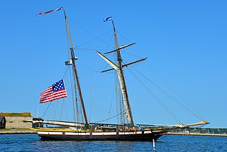
Lynx is a square topsail schooner based in Nantucket, Massachusetts. She is an interpretation of an American letter of marque vessel of the same name from 1812. The original Lynx completed one voyage, running the Royal Navy blockade; the British captured her in 1813 at the start of her second voyage and took her into service as HMS Mosquidobit.

The Midcoast is a region of the U.S. state of Maine that includes the coastal counties of Waldo, Knox, Lincoln, and Sagadahoc; and a small part of Cumberland County. The Midcoast is a popular tourist destination, and many people own summer homes in the region. The area includes much of Maine's rock-bound coast.

The Sauda class was a class of nine minesweepers and one minehunter in service for the Royal Norwegian Navy from 1953 to 1996. The class was designed at Sparkman & Stephens Inc., New York City, as an improvement of the NYMS class. Five of the vessels were built in the United States, three were built at Westermoen Båtbyggeri og Mek Verksted in Mandal, one at Skaalurens Skibsbyggeri in Rosendal and one at De Forenede Båtbyggerier in Risør. The class was fully financed by the US government as a part of the Military Assistance Program (MAP).
Damariscove is an uninhabited island that is part of Boothbay Harbor in Lincoln County, Maine, United States, approximately 5 nautical miles (9.3 km) off the coast at the mouth of the Damariscotta River. The long, narrow island is approximately 2 miles (3.2 km) long and 1,500 feet (460 m) at its widest point. The island has served in the past as a fishing settlement and a United States Coast Guard life saving station.

Ram Island Light is a lighthouse located just offshore of Ram Island, marking the eastern entrance to Boothbay Harbor, Maine, and the west side of the mouth of the Damariscotta River. It was built in 1883 and automated in 1965. It was listed on the National Register of Historic Places as Ram Island Light Station on January 21, 1988.

Boothbay Harbor is a census-designated place (CDP) comprising the densely populated center of the town of Boothbay Harbor in Lincoln County, Maine, United States. The population was 1,086 at the 2010 census, down from 1,237 at the 2000 census.

Boothbay Harbor is a town in Lincoln County, Maine, United States. The population was 2,027 at the 2020 census. It includes the neighborhoods of Bayville, Mount Pisgah, and Sprucewold, and the villages of Isle of Springs and West Boothbay Harbor. During summer months, the entire Boothbay Harbor region is a popular yachting and tourist destination.

Hodgdon Yachts is a builder of yachts and specialized military vessels, based in East Boothbay, Maine. It is a family-run business that was founded in 1816—the oldest continuously operating family boatbuilder in the United States, predating the Burger Boat Company of Manitowoc, Wisconsin, by 47 years. Hodgdon Yachts is noted for building superyachts, both sail and power, using advanced composite materials and construction techniques. It's also noted for its ability to incorporate those advanced materials into traditional designs that employ modern electronic and mechanical marine systems. The company has several divisions—yachts, custom tenders, yacht interiors, yacht services and military composites with offices in Boothbay, Maine, Newport, Rhode Island and Monaco.
West Boothbay Harbor is an unincorporated village in the town of Boothbay Harbor, Lincoln County, Maine, United States. The community is located along Maine State Route 27, 10.7 miles (17.2 km) south of Wiscasset. West Boothbay Harbor has a post office, with ZIP code 04575.
Matthew Forgues is an American racewalker. Forgues earned gold for the 50 kilometres race walk at the 2019 USA Outdoor Track and Field Championships. Forgues was runner up in the 50 km walk at the 2020 United States Olympic Trials in Santee, California in a time of 4:14:42.


