Alna, Maine

Last updated

Alna, Maine
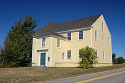
Alna ME DSC 0007.jpg
Alna Meeting House, built in 1789
200 Town Seal.jpg
Lincoln County Maine incorporated and unincorporated areas Alna highlighted.svg
Location in Lincoln County and the state of Maine.
Coordinates: 44°5′6″N69°37′31″W / 44.08500°N 69.62528°W / 44.08500; -69.62528
Country United States
State Maine
County Lincoln
Settled1760
Incorporated1794
Government
  Type Town Meeting
Area
[1]
  Total21.32 sq mi (55.22 km2)
  Land20.90 sq mi (54.13 km2)
  Water0.42 sq mi (1.09 km2)
Elevation
128 ft (39 m)
Population
 (2020) [2]
  Total710
  Density34/sq mi (13.1/km2)
Time zone UTC-5 (Eastern)
  Summer (DST) UTC-4 (Eastern)
ZIP code
04535
Area code 207
FIPS code 23-01010
GNIS feature ID0582321
Website http://alna.maine.gov

Alna is a town in Lincoln County, Maine, United States. The population was 710 at the 2020 census. [3] Alna is home to the Wiscasset, Waterville and Farmington Railway Museum and is noted for its historic architecture, including the early mill village of Head Tide.

Contents

History

Pulpit at the Alna Meeting House Alna ME DSC 0009.jpg
Pulpit at the Alna Meeting House

Originally a part of old Pownalborough, the town was settled around 1760 and incorporated in 1794 by the Massachusetts General Court as New Milford. But residents did not like the name, so it was changed in 1811 to Alna, Latin for alder, the tree which grows in profusion along the banks of the Sheepscot River. [4]

Alna was the site of the first fish hatchery in Maine, started shortly after the Civil War. Between 1895 and 1933, the narrow gauge Wiscasset, Waterville & Farmington Railway operated three stations in the town: Head Tide, Alna Center, and Sheepscot. The latter now serves as the base of operations for a heritage railway in town. [5]

Geography

According to the United States Census Bureau, the town has a total area of 21.32 square miles (55.22 km2), of which 20.90 square miles (54.13 km2) is land and 0.42 square miles (1.09 km2) is water. [1] Alna is drained by the Sheepscot River.

The town in crossed by Maine State Route 194 and Maine State Route 218. It borders the towns of Wiscasset to the south; Dresden to the west; Pittston, Whitefield and Jefferson to the north; and across the Sheepscot River, Newcastle to the east.

Demographics

Historical population
CensusPop.Note
1800 636
1810 79725.3%
1820 97822.7%
1830 1,17520.1%
1840 990−15.7%
1850 916−7.5%
1860 805−12.1%
1870 747−7.2%
1880 687−8.0%
1890 512−25.5%
1900 444−13.3%
1910 4572.9%
1920 320−30.0%
1930 294−8.1%
1940 33915.3%
1950 3503.2%
1960 347−0.9%
1970 315−9.2%
1980 42534.9%
1990 57134.4%
2000 67518.2%
2010 7095.0%
2020 7100.1%
U.S. Decennial Census [6]

2010 census

As of the census [2] of 2010, there were 709 people, 295 households, and 210 families living in the town. The population density was 33.9 inhabitants per square mile (13.1/km2). There were 346 housing units at an average density of 16.6 per square mile (6.4/km2). The racial makeup of the town was 97.5% White, 0.1% African American, 1.1% Native American, 0.4% Asian, 0.1% from other races, and 0.7% from two or more races. Hispanic or Latino of any race were 0.6% of the population.

There were 295 households, of which 28.1% had children under the age of 18 living with them, 60.0% were married couples living together, 6.8% had a female householder with no husband present, 4.4% had a male householder with no wife present, and 28.8% were non-families. 21.0% of all households were made up of individuals, and 6.7% had someone living alone who was 65 years of age or older. The average household size was 2.40 and the average family size was 2.78.

The median age in the town was 45.7 years. 20.9% of residents were under the age of 18; 5.5% were between the ages of 18 and 24; 22.1% were from 25 to 44; 35.2% were from 45 to 64; and 16.2% were 65 years of age or older. The gender makeup of the town was 48.7% male and 51.3% female.

2000 census

As of the census [7] of 2000, there were 675 people, 266 households, and 197 families living in the town. The population density was 32.3 inhabitants per square mile (12.5/km2). There were 315 housing units at an average density of 15.1 per square mile (5.8/km2). The racial makeup of the town was 99.56% White, 0.30% Native American and 0.15% Asian. Hispanic or Latino of any race were 0.15% of the population. 0.1% African Americans.

There were 266 households, out of which 34.6% had children under the age of 18 living with them, 64.3% were married couples living together, 6.4% had a female householder with no husband present, and 25.6% were non-families. 19.9% of all households were made up of individuals, and 9.4% had someone living alone who was 65 years of age or older. The average household size was 2.54 and the average family size was 2.94.

In the town, the population was spread out, with 25.0% under the age of 18, 4.9% from 18 to 24, 27.4% from 25 to 44, 28.6% from 45 to 64, and 14.1% who were 65 years of age or older. The median age was 41 years. For every 100 females there were 99.7 males. For every 100 females age 18 and over, there were 96.9 males.

The median income for a household in the town was $43,125, and the median income for a family was $48,611. Males had a median income of $34,375 versus $23,977 for females. The per capita income for the town was $17,340. About 6.7% of families and 6.3% of the population were below the poverty line, including 5.7% of those under age 18 and 10.1% of those age 65 or over.
Sites of interest

The Wiscasset, Waterville & Farmington Railway Museum WW&FR 10.jpg
The Wiscasset, Waterville & Farmington Railway Museum

Notable people

Related Research Articles

<span class="mw-page-title-main">Lincoln County, Maine</span> County in Maine, United States

Lincoln County is a county located in the U.S. state of Maine. As of the 2020 census, the population was 35,237. Its seat is Wiscasset. The county was founded in 1760 by the Massachusetts General Court from a portion of York County, Massachusetts and named after the English city Lincoln, the birthplace of Massachusetts Bay Provincial Governor Thomas Pownall.

Avon is a town in Franklin County, Maine, United States. The population was 450 at the 2020 census. Avon is home to Mount Blue, part of Mount Blue State Park.

<span class="mw-page-title-main">Strong, Maine</span> Town in Maine, United States

Strong is a town in Franklin County, Maine, United States. The population was 1,122 at the 2020 census. Strong is home to the annual Sandy River Festival.

<span class="mw-page-title-main">Albion, Maine</span> Town in the state of Maine, United States

Albion is a town in Kennebec County, Maine, United States. The population was 2,006 at the 2020 census.

<span class="mw-page-title-main">Vassalboro, Maine</span> Town in Maine, United States

Vassalboro is a town in Kennebec County, Maine, United States. The population was 4,520 at the 2020 census. Vassalboro includes the villages of Riverside, Getchell's Corner, North Vassalboro, and East Vassalboro, home to the town library and sports field. Vassalboro is included in the Augusta, Maine, micropolitan New England City and Town Area.

<span class="mw-page-title-main">Boothbay, Maine</span> Town in Maine, United States

Boothbay is a town in Lincoln County, Maine, United States. The population was 3,003 at the 2020 census. It includes the neighborhoods of Back Narrows, Dover, Linekin, Oak Hill, Ocean Point, Spruce Shores, and the villages of East Boothbay and Trevett. The surrounding Boothbay Region is a center of summer tourist activity, and a significant part of its population does not live there year-round. Five shipyards are located in the town, the largest of which is Washburn & Doughty.

<span class="mw-page-title-main">Dresden, Maine</span> Town in the state of Maine, United States

Dresden is a town in Lincoln County, Maine, United States, that was incorporated in 1794. The population was 1,725 at the 2020 census.

<span class="mw-page-title-main">Jefferson, Maine</span> Town in the state of Maine, United States

Jefferson is a town in Lincoln County, Maine, United States. The population was 2,551 at the 2020 census. Damariscotta Lake State Park, a popular Mid Coast swimming, canoeing and picnic area, is located within the town limits.

<span class="mw-page-title-main">Newcastle, Maine</span> Town in the state of Maine, United States

Newcastle is a town in Lincoln County, Maine, United States. The population was 1,848 at the 2020 census. The village of Newcastle is located in the eastern part of the town, on the Damariscotta River. Together with the village of Damariscotta linked by the Main Street bridge, they form the Twin Villages.

<span class="mw-page-title-main">Southport, Maine</span> Town in the state of Maine, United States

Southport is a town and archipelago in Lincoln County, Maine, United States. The population was 622 at the 2020 census. It includes the neighborhoods of Capitol Island, Cozy Harbor, East Side, Newagen, Pine Cliff, and West Southport, and the village of Squirrel Island. The majority of the town's residents live on its main island, Southport Island.

<span class="mw-page-title-main">Solon, Maine</span> Town in the state of Maine, United States

Solon is a town in Somerset County, Maine, United States. The population was 978 at the 2020 census.

<span class="mw-page-title-main">Palermo, Maine</span> Town in Maine, United States

Palermo is a town in Waldo County, Maine, United States. The population was 1,570 at the 2020 census. Palermo is included in the Augusta, Maine, micropolitan New England City and Town Area.

<span class="mw-page-title-main">Winslow, Maine</span> Town in the state of Maine, United States

Winslow is a town and census-designated place in Kennebec County, Maine, United States, along the Kennebec River across from Waterville. The population was 7,948 at the 2020 census.

<span class="mw-page-title-main">Oakland, Maine</span> Town in the state of Maine, United States

Oakland is a town in Kennebec County in the U.S. state of Maine. The population was 6,230 at the 2020 census. Oakland is 4 miles (6 km) west of Waterville and approximately 18 miles (29 km) north of Augusta, the state capital. Waterville and Augusta are service centers for Oakland, and many Oakland residents commute to jobs in those areas.

<span class="mw-page-title-main">Westport Island, Maine</span> Town in the state of Maine, United States

Westport Island, formerly Westport, is a town in Lincoln County, Maine, United States. In the 19th century the island was known as Jeremysquam, a nickname islanders still use for it. The population was 719 at the 2020 census.

<span class="mw-page-title-main">Wiscasset, Waterville and Farmington Railway</span> Railway in Maine, USA

The Wiscasset, Waterville and Farmington Railway is a 2 ft narrow gauge railway. The line was operated as a for-profit company from 1895 until 1933 between the Maine towns of Wiscasset, Albion, and Winslow, but was abandoned in 1936. Today, about three miles (4.8 km) of the track in the town of Alna has been rebuilt and is operated by the non-profit Wiscasset, Waterville and Farmington Railway Museum as a heritage railroad offering passenger excursion trains and hauling occasional cargo.

<span class="mw-page-title-main">Boothbay Harbor, Maine</span> Town in Maine, United States

Boothbay Harbor is a town in Lincoln County, Maine, United States. The population was 2,027 at the 2020 census. It includes the neighborhoods of Bayville, Mount Pisgah, and Sprucewold, and the villages of Isle of Springs and West Boothbay Harbor. During summer months, the entire Boothbay Harbor region is a popular yachting and tourist destination.

<span class="mw-page-title-main">Wiscasset (CDP), Maine</span> Census-designated place in Maine, United States

Wiscasset is a census-designated place (CDP) comprising the primary settlement in the town of Wiscasset in Lincoln County, Maine, United States. The population was 1,232 at the 2020 census, out of 3,732 people in the entire town. Wiscasset is the county seat of Lincoln County.

<span class="mw-page-title-main">Wiscasset, Maine</span> Town in Maine, United States

Wiscasset is a town in and the seat of Lincoln County, Maine, United States. The municipality is located in the state of Maine's Mid Coast region. The population was 3,742 as of the 2020 census. Home to the Chewonki Foundation, Wiscasset is a tourist destination noted for early architecture and as the location of Red's Eats restaurant.

<span class="mw-page-title-main">Bingham, Maine</span> Town in the state of Maine, United States

Bingham is a town in Somerset County, Maine, United States. The population was 866 at the 2020 census. Bingham is a historic town located beside the Kennebec River.

References

  1. 1 2 "US Gazetteer files 2010". United States Census Bureau . Retrieved December 16, 2012.
  2. 1 2 "U.S. Census website". United States Census Bureau . Retrieved December 16, 2012.
  3. "Census - Geography Profile: Alna town, Lincoln County, Maine" . Retrieved January 23, 2022.
  4. Coolidge, Austin J.; John B. Mansfield (1859). A History and Description of New England. Boston, Massachusetts: A.J. Coolidge. p.  29. coolidge mansfield history description new england 1859.
  5. WW&F Railway History
  6. "Census of Population and Housing". Census.gov. Retrieved June 4, 2015.
  7. "U.S. Census website". United States Census Bureau . Retrieved January 31, 2008.

44°06′22″N69°36′13″W / 44.10611°N 69.60361°W / 44.10611; -69.60361