South Bristol, Maine

Last updated

South Bristol, Maine
South Bristol Gut.jpg
South Bristol Gut in 2022
Lincoln County Maine incorporated and unincorporated areas South Bristol highlighted.svg
Location in Lincoln County and the state of Maine
Coordinates: 43°53′50″N69°33′53″W / 43.89722°N 69.56472°W / 43.89722; -69.56472
Country United States
State Maine
County Lincoln
Incorporated1915
Area
[1]
  Total29.68 sq mi (76.87 km2)
  Land13.10 sq mi (33.93 km2)
  Water16.58 sq mi (42.94 km2)
Elevation
43 ft (13 m)
Population
 (2020)
  Total1,127
  Density86/sq mi (33.2/km2)
Time zone UTC-5 (Eastern (EST))
  Summer (DST) UTC-4 (EDT)
ZIP code
04568
Area code 207
FIPS code 23-70240
GNIS feature ID0582733
Website www.townofsouthbristol.com

South Bristol is a town in Lincoln County, Maine, United States. The population was 1,127 at the 2020 census. [2] A fishing and resort area, South Bristol includes the villages of Walpole and Christmas Cove, the latter on Rutherford Island. The town has six nature preserves.

Contents

History

The town was once territory of the Wawenock (or more precisely Walinakiak, meaning "People of the Bays") Abenaki people, who traveled in canoes to hunt for fish, shellfish, seals and seafowl. In 1614, Captain John Smith explored the coast, and is said to have named Christmas Cove when he visited it on Christmas Day. The land was subsequently part of the Pemaquid Patent, granted by the Plymouth Council for New England in 1631 to Robert Aldsworth and Gyles Elbridge, merchants from Bristol, England, from which the town derives its name. [3]

A palisade fort and settlement were built on the adjacent Pemaquid Peninsula. Between 1630 and 1650, the area was the center for fur trading in Maine. It was attacked and rebuilt repeatedly during the French and Indian Wars, with the final two attacks occurring in 1747 at Fort Frederick. In 1765, Bristol was incorporated as a town, with South Bristol its western portion. [3] On March 26, 1915, South Bristol was set off and incorporated as a separate town. [4]

In the 1800s, the village of Walpole was noted for brickmaking and ice harvesting. Brickyards along the Damariscotta River supplied many of the bricks used to build Boston's Back Bay neighborhood. The ice business faded with the advent of refrigeration, but the Thompson Ice House, established in 1826, is now preserved as the Thompson Ice Harvesting Museum. The Bristol Yacht Building Company, later known as H.F. Gamage Shipbuilding, built minesweepers for the United States Navy during World War II. [5] Shipbuilding has remained important, with schooners, fishing trawlers, lobster boats and yachts constructed at the town. [6] The Hudson River Sloop Clearwater was built here in 1968. Other industries in South Bristol are fishing, lobstering, clamming, aquaculture and tourism. [4]

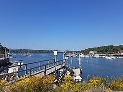
The peninsula and Rutherford Island were connected by a swing bridge, one of only three in Maine, which spanned "The Gut." In 2017 the swing bridge was replaced with a safer drawbridge. For well over a century, Rutherford Island in particular has been a vacation destination for families from Massachusetts, Connecticut, New York and New Jersey. Many homes on the island are owned by these families. [7]

Geography

The town is in southern Lincoln County, bordered to the west by the tidal Damariscotta River, to the east by Johns Bay and the tidal Johns River, and to the south by the Atlantic Ocean. The southern one-third of the town is on Rutherford Island, separated from the mainland by The Gut. The island was named after the Reverend Robert Rutherford, who came with David Dunbar's group to the area from North Ireland in 1729. The village of South Bristol is on both sides of The Gut, while Christmas Cove is at the south end of Rutherford Island, and the locales of West Bristol and Walpole are to the north on the mainland. The town of Bristol is to the east and north, while the towns of Newcastle, Edgecomb, and Boothbay (listed from north to south) are to the west across the Damariscotta River.

According to the United States Census Bureau, the town of South Bristol has a total area of 29.68 square miles (76.87 km2), of which 13.10 square miles (33.93 km2) are land and 16.58 square miles (42.94 km2), or 55.85%, are water. [1]

The town is crossed by Maine State Route 129. The highway leads north to Damariscotta, 13 miles (21 km) from South Bristol village.

Demographics

Historical population
CensusPop.Note
1920 581
1930 563−3.1%
1940 5823.4%
1950 6318.4%
1960 610−3.3%
1970 6648.9%
1980 80020.5%
1990 8253.1%
2000 8978.7%
2010 892−0.6%
2020 1,12726.3%
U.S. Decennial Census [8]
The former swing bridge Preston-south bristol bridge.jpg
The former swing bridge

2010 census

As of the census [9] of 2010, there were 892 people, 418 households, and 275 families residing in the town. The population density was 68.1 inhabitants per square mile (26.3/km2). There were 1,076 housing units at an average density of 82.1 per square mile (31.7/km2). The racial makeup of the town was 98.5% White, 0.6% African American, 0.1% Native American, 0.2% Asian, and 0.6% from two or more races. Hispanic or Latino of any race were 0.6% of the population.

There were 418 households, of which 19.6% had children under the age of 18 living with them, 55.7% were married couples living together, 8.1% had a female householder with no husband present, 1.9% had a male householder with no wife present, and 34.2% were non-families. 29.4% of all households were made up of individuals, and 16% had someone living alone who was 65 years of age or older. The average household size was 2.13 and the average family size was 2.57.

The median age in the town was 54.1 years. 15.8% of residents were under the age of 18; 3.8% were between the ages of 18 and 24; 17.2% were from 25 to 44; 32.9% were from 45 to 64; and 30.2% were 65 years of age or older. The gender makeup of the town was 48.4% male and 51.6% female.

2000 census

As of the census [10] of 2000, there were 897 people, 410 households, and 277 families residing in the town. The population density was 68.0 inhabitants per square mile (26.3/km2). There were 932 housing units at an average density of 70.7 per square mile (27.3/km2). The racial makeup of the town was 99.00% White, 0.11% Native American, 0.22% Asian, and 0.67% from two or more races. Hispanic or Latino of any race were 0.45% of the population.

There were 410 households, out of which 20.5% had children under the age of 18 living with them, 60.0% were married couples living together, 4.9% had a female householder with no husband present, and 32.2% were non-families. 25.4% of all households were made up of individuals, and 12.9% had someone living alone who was 65 years of age or older. The average household size was 2.19 and the average family size was 2.58.

In the town, the population was spread out, with 16.7% under the age of 18, 4.6% from 18 to 24, 18.8% from 25 to 44, 34.9% from 45 to 64, and 25.0% who were 65 years of age or older. The median age was 52 years. For every 100 females, there were 98.5 males. For every 100 females age 18 and over, there were 97.6 males.

The median income for a household in the town was $38,636, and the median income for a family was $46,765. Males had a median income of $31,696 versus $21,563 for females. The per capita income for the town was $28,233. About 3.5% of families and 7.5% of the population were below the poverty line, including 6.0% of those under age 18 and 15.0% of those age 65 or over.

Sites of interest

Related Research Articles

<span class="mw-page-title-main">Lincoln County, Maine</span> County in Maine, United States

Lincoln County is a county located in the U.S. state of Maine. As of the 2020 census, the population was 35,237. Its seat is Wiscasset. The county was founded in 1760 by the Massachusetts General Court from a portion of York County, Massachusetts and named after the English city Lincoln, the birthplace of Massachusetts Bay Provincial Governor Thomas Pownall.

<span class="mw-page-title-main">Frenchville, Maine</span> Town in the state of Maine, United States

Frenchville is a town in Aroostook County, Maine, United States. The population was 1,052 at the 2020 census.

<span class="mw-page-title-main">Grand Isle, Maine</span> Town in the state of Maine, United States

Grand Isle is a town in Aroostook County, Maine, United States. The population was 366 at the 2020 census. The village of Grand Isle is in the northwestern part of the town.

<span class="mw-page-title-main">Island Falls, Maine</span> Town in the state of Maine, United States

Island Falls is a town in Aroostook County, Maine, United States. The population was 758 at the 2020 census. The primary village of Island Falls in the town is situated at a falls in the West Branch Mattawamkeag River.

<span class="mw-page-title-main">Standish, Maine</span> Town in the state of Maine, United States

Standish is a town in Cumberland County, Maine, United States. The population was 10,244 at the 2020 census. It includes the villages of Standish Corner, Sebago Lake Village and Steep Falls, and the localities known as Richville, Elmwood, Standish Neck and Two Trails. Standish is part of the Portland-South Portland-Biddeford, Maine metropolitan statistical area.

<span class="mw-page-title-main">Verona Island, Maine</span> Town in Maine, United States

Verona Island is a town located on an island of the same name in the Penobscot River in Hancock County, Maine, United States. The population was 507 at the 2020 census.

<span class="mw-page-title-main">Boothbay, Maine</span> Town in Maine, United States

Boothbay is a town in Lincoln County, Maine, United States. The population was 3,003 at the 2020 census. It includes the villages of Back Narrows, Dover, East Boothbay, Linekin, Oak Hill, Ocean Point, Spruce Shores, and Trevett. The Boothbay region is a center of summer tourist activity, and a significant part of its population does not live there year-round. Five shipyards are located in the town, the largest of which is Washburn & Doughty.

<span class="mw-page-title-main">Bremen, Maine</span> Town in the state of Maine, United States

Bremen is a small town in Lincoln County, Maine, United States. The population was 823 at the 2020 census. Located on Muscongus Bay and the Gulf of Maine, it includes the villages of Broad Cove, Turners Corner, Bremen, Medomak and Muscongus. Hog Island is a center and camp for the Maine chapter of the National Audubon Society.

<span class="mw-page-title-main">Bristol, Maine</span> Town in Maine, United States

Bristol, known from 1632 to 1765 as Pemaquid is a town in Lincoln County, Maine, United States. The population was 2,834 at the 2020 census. A fishing and resort area, Bristol includes the villages of New Harbor, Pemaquid, Round Pond, Bristol Mills and Chamberlain. It includes the Pemaquid Archeological Site, a U.S. National Historic Landmark. During the 17th and early 18th century, New France defined the Kennebec River as the southern boundary of Acadia, which put Bristol within Acadia.

<span class="mw-page-title-main">Damariscotta, Maine</span> Town in the state of Maine, United States

Damariscotta is a town in Lincoln County, Maine, United States. The population was 2,297 at the 2020 census. Damariscotta is the oyster capital of New England. A popular tourist destination, the towns of Damariscotta and Newcastle are linked by the Main Street bridge over the Damariscotta River, forming the "Twin Villages". The name Damariscotta derives from a native place-name meaning place of abundance of small fish (alewives).

Damariscotta-Newcastle was a census-designated place (CDP) in Lincoln County, Maine, United States. It designated a concentration of population around where the most developed portions of the towns of Damariscotta and Newcastle meet, generally corresponding to the "Twin Villages" area. As of the 2000 census, the CDP population was 1,751. For the 2010 census, the area was delineated as two separate CDPs, Damariscotta and Newcastle.

<span class="mw-page-title-main">Jefferson, Maine</span> Town in the state of Maine, United States

Jefferson is a town in Lincoln County, Maine, United States. The population was 2,551 at the 2020 census. Damariscotta Lake State Park, a popular Mid Coast swimming, canoeing and picnic area, is located within the town limits.

<span class="mw-page-title-main">Newcastle, Maine</span> Town in the state of Maine, United States

Newcastle is a town in Lincoln County, Maine, United States. The population was 1,848 at the 2020 census. The village of Newcastle is located in the eastern part of the town, on the Damariscotta River. Together with the village of Damariscotta linked by the Main Street bridge, they form the Twin Villages.

<span class="mw-page-title-main">Nobleboro, Maine</span> Town in Maine, United States

Nobleboro, founded in 1788, is a town in Lincoln County, Maine, United States. The population was 1,791 at the 2020 census. Nobleboro is named for Arthur Noble's son Arthur II. Part of Nobleboro was part of Shem Drowne's claim in the 1730s.

Embden is a town in Somerset County, Maine, United States. The population was 902 at the 2020 census.

<span class="mw-page-title-main">Islesboro, Maine</span> Town in Waldo County, Maine, United States

Islesboro is a town in Waldo County, Maine, United States, comprising Islesboro Island and several smaller islands. The population was 583 at the 2020 census. It has a summer colony accessible by state ferry service from Lincolnville Beach three miles to the west, by private boat, or by air taxi service. Home to Warren Island State Park, Islesboro includes the village of Dark Harbor.

<span class="mw-page-title-main">Village Green-Green Ridge, Pennsylvania</span> Census-designated place in Pennsylvania, United States

Village Green-Green Ridge is a census-designated place (CDP) in Delaware County, Pennsylvania, United States. The population was 7,822 at the 2010 census, down from 8,279 at the 2000 census.

<span class="mw-page-title-main">Weber City, Virginia</span> Town in Virginia, United States

Weber City is an incorporated town in Scott County, Virginia, United States. The population was 1,327 at the 2010 census. It is part of the Kingsport–Bristol (TN)–Bristol (VA) Metropolitan Statistical Area, which is a component of the Johnson City–Kingsport–Bristol, TN-VA Combined Statistical Area – commonly known as the "Tri-Cities" region.

<span class="mw-page-title-main">Waldoboro (CDP), Maine</span> Census-designated place in Maine, United States

Waldoboro is a census-designated place (CDP) comprising the central village in the town of Waldoboro in Lincoln County, Maine, United States. The population was 1,300 at the 2020 census, out of 5,075 people in the entire town of Waldoboro.

<span class="mw-page-title-main">Wiscasset (CDP), Maine</span> Census-designated place in Maine, United States

Wiscasset is a census-designated place (CDP) comprising the primary settlement in the town of Wiscasset in Lincoln County, Maine, United States. The population was 1,232 at the 2020 census, out of 3,732 people in the entire town. Wiscasset is the county seat of Lincoln County.

References

  1. 1 2 "US Gazetteer files 2010". United States Census Bureau . Retrieved December 16, 2012.
  2. "Census - Geography Profile: South Bristol town, Lincoln County, Maine" . Retrieved January 22, 2022.
  3. 1 2 Coolidge, Austin J.; John B. Mansfield (1859). A History and Description of New England. Boston, Massachusetts: A.J. Coolidge. pp.  66–72.
  4. 1 2 Maine Genealogy: South Bristol, Lincoln County, Maine
  5. "U.S.Navy Activities World War II by State". U.S. Naval Historical Center. Retrieved March 7, 2012.
  6. Varney, George J. (1886), Gazetteer of the state of Maine. Bristol, Boston: Russell
  7. History of South Bristol, Maine Archived 2011-07-14 at the Wayback Machine
  8. "Census of Population and Housing". Census.gov. Retrieved June 4, 2015.
  9. "U.S. Census website". United States Census Bureau . Retrieved December 16, 2012.
  10. "U.S. Census website". United States Census Bureau . Retrieved January 31, 2008.

43°51′50″N69°33′40″W / 43.86389°N 69.56111°W / 43.86389; -69.56111