Wiscasset (CDP), Maine

Last updated

Wiscasset, Maine
Lincoln County Maine incorporated and unincorporated areas Wiscasset (CDP) highlighted.svg
Location in Lincoln County and the state of Maine
Coordinates: 44°0′15″N69°40′2″W / 44.00417°N 69.66722°W / 44.00417; -69.66722
CountryUnited States
State Maine
County Lincoln
Town Wiscasset
Area
[1]
  Total3.93 sq mi (10.19 km2)
  Land3.90 sq mi (10.10 km2)
  Water0.04 sq mi (0.09 km2)
Elevation
90 ft (30 m)
Population
 (2020)
  Total1,232
  Density315.98/sq mi (122.00/km2)
Time zone UTC-5 (Eastern (EST))
  Summer (DST) UTC-4 (EDT)
ZIP code
04578
Area code 207
FIPS code 23-87040
GNIS feature ID0578612

Wiscasset is a census-designated place (CDP) comprising the primary settlement in the town of Wiscasset in Lincoln County, Maine, United States. The population was 1,232 at the 2020 census, [2] out of 3,732 people in the entire town. Wiscasset is the county seat of Lincoln County.

Contents

Geography

The Wiscasset CDP is located in the east-central part of the town of Wiscasset at 44°00′19″N69°40′13″W / 44.005362°N 69.670372°W / 44.005362; -69.670372 (44.005362, −69.670372), [3] in western Lincoln County. The village sits on the west side of the tidal Sheepscot River, which forms the boundary with the town of Edgecomb to the east. The CDP extends along the Sheepscot south to Birch Point and north to an unnamed cove downstream from Clark Point. The CDP extends west as far as Ward Brook and north to a powerline near Foye Road. [4]

U.S. Route 1 passes through the center of the village as Main Street, heading east across the Sheepscot River on the Donald E. Davey Bridge into the northern part of Edgecomb. US 1 leads northeast 8 miles (13 km) to Damariscotta and southwest 10 miles (16 km) to Bath. Portland is 44 miles (71 km) to the southwest. Maine State Route 27 enters Wiscasset from the east with US 1, but turns and leads north 17 miles (27 km) to Gardiner and 23 miles (37 km) to Augusta, the state capital. ME 27 splits off US 1 in Edgecomb and leads south to Boothbay Harbor, 13 miles (21 km) from Wiscasset. Maine State Route 218 (Federal Street) leads northeast out of Wiscasset 13 miles (21 km) to Whitefield.

According to the United States Census Bureau, the Wiscasset CDP has a total area of 3.9 square miles (10.2 km2), of which 3.9 square miles (10.1 km2) are land and 0.04 square miles (0.1 km2), or 0.89%, are water. [5] It is home to Wiscasset High School.

Demographics

Historical population
CensusPop.Note
2020 1,232
U.S. Decennial Census [6]

As of the census [7] of 2000, there were 1,203 people, 532 households, and 319 families residing in the CDP. The population density was 309.8 inhabitants per square mile (119.6/km2). There were 603 housing units at an average density of 155.3 per square mile (60.0/km2). The racial makeup of the CDP was 99.09% White, 0.42% Black or African American, 0.17% Asian, and 0.33% from two or more races. Hispanic or Latino of any race were 0.25% of the population.

There were 532 households, out of which 25.2% had children under the age of 18 living with them, 47.9% were married couples living together, 8.8% had a female householder with no husband present, and 40.0% were non-families. 34.8% of all households were made up of individuals, and 15.2% had someone living alone who was 65 years of age or older. The average household size was 2.24 and the average family size was 2.89.

In the CDP, the population was spread out, with 22.3% under the age of 18, 6.6% from 18 to 24, 23.1% from 25 to 44, 28.8% from 45 to 64, and 19.3% who were 65 years of age or older. The median age was 44 years. For every 100 females, there were 93.7 males. For every 100 females age 18 and over, there were 90.0 males.

The median income for a household in the CDP was $30,341, and the median income for a family was $46,250. Males had a median income of $26,827 versus $25,081 for females. The per capita income for the CDP was $20,043. About 11.7% of families and 15.5% of the population were below the poverty line, including 24.9% of those under age 18 and 16.1% of those age 65 or over.

Related Research Articles

<span class="mw-page-title-main">Lincoln County, Maine</span> County in Maine, United States

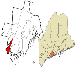
Lincoln County is a county located in the U.S. state of Maine. As of the 2020 census, the population was 35,237. Its seat is Wiscasset. The county was founded in 1760 by the Massachusetts General Court from a portion of York County, Massachusetts and named after the English city Lincoln, the birthplace of Massachusetts Bay Provincial Governor Thomas Pownall.

<span class="mw-page-title-main">Alna, Maine</span> Town in the state of Maine, United States

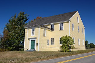
Alna is a town in Lincoln County, Maine, United States. The population was 710 at the 2020 census. Alna is home to the Wiscasset, Waterville and Farmington Railway Museum and is noted for its historic architecture, including the early mill village of Head Tide.

<span class="mw-page-title-main">Edgecomb, Maine</span> Town in the state of Maine, United States

Edgecomb is a town in Lincoln County, Maine, United States. The population was 1,188 at the 2020 census. It includes the villages of East Edgecomb, North Edgecomb, and Pools Landing. The town was named for George Edgcumbe, 1st Earl of Mount Edgcumbe, a supporter of the colonists. Fort Edgecomb is a Maine State Historic Site.

<span class="mw-page-title-main">Newcastle, Maine</span> Town in the state of Maine, United States

Newcastle is a town in Lincoln County, Maine, United States. The population was 1,848 at the 2020 census. The village of Newcastle is located in the eastern part of the town, on the Damariscotta River. Together with the village of Damariscotta linked by the Main Street bridge, they form the Twin Villages.

<span class="mw-page-title-main">Van Buren (CDP), Maine</span> Census-designated place in Maine, United States

Van Buren is a census-designated place (CDP) comprising the main village within the town of Van Buren in Aroostook County, Maine, United States. The population of the CDP was 1,937 at the 2010 census, out of a population of 2,171 for the entire town.

<span class="mw-page-title-main">Westport Island, Maine</span> Town in the state of Maine, United States

Westport Island, formerly Westport, is a town in Lincoln County, Maine, United States. In the 19th century the island was known as Jeremysquam, a nickname islanders still use for it. The population was 719 at the 2020 census.

<span class="mw-page-title-main">Farmington (CDP), Maine</span> Census-designated place in Maine, United States

Farmington is a census-designated place (CDP) comprising the center of the town of Farmington, which is the county seat of Franklin County in Maine, United States. The population of the CDP was 4,288 at the 2010 census, out of 7,760 people in the town as a whole. The University of Maine at Farmington is located within the CDP.

Bucksport is a census-designated place (CDP) in the town of Bucksport in Hancock County, Maine, United States. The population was 2,885 at the 2010 census, down from 2,970 at the 2000 census.

<span class="mw-page-title-main">Clinton (CDP), Maine</span> Census-designated place in Maine, United States

Clinton is a census-designated place (CDP) and the primary village in the town of Clinton in Kennebec County, Maine, United States. The population was 1,419 at the 2010 census, out of 3,486 in the entire town of Clinton.

<span class="mw-page-title-main">Farmingdale (CDP), Maine</span> Census-designated place in Maine, United States

Farmingdale is a census-designated place (CDP) in the town of Farmingdale in Kennebec County, Maine, United States. The population was 1,970 at the 2010 census, out of 2,956 in the entire town.

<span class="mw-page-title-main">Oakland (CDP), Maine</span> Census-designated place in Maine, United States

Oakland is a census-designated place (CDP) comprising the main population center in the town of Oakland in Kennebec County, Maine, United States. The population was 2,602 at the 2010 census, out of 6,240 in the entire town of Oakland.

<span class="mw-page-title-main">Winthrop (CDP), Maine</span> Census-designated place in Maine, United States

Winthrop is a census-designated place (CDP) comprising the primary settlement in the town of Winthrop in Kennebec County, Maine, United States. The population was 2,650 at the 2010 census, out of 6,092 in the town of Winthrop as a whole.

<span class="mw-page-title-main">Camden (CDP), Maine</span> Census-designated place in Maine, United States

Camden is a census-designated place (CDP) comprising the main village in the town of Camden in Knox County, Maine, United States. The population was 3,570 at the 2010 census, out of 4,850 in the entire town of Camden.

<span class="mw-page-title-main">Thomaston (CDP), Maine</span> Census-designated place in Maine, United States

Thomaston is a census-designated place (CDP) comprising the main village in the town of Thomaston in Knox County, Maine, United States. The population was 1,875 at the 2010 census, out of 2,781 in the town of Thomaston as a whole.

<span class="mw-page-title-main">Boothbay Harbor (CDP), Maine</span> Census-designated place in Maine, United States

Boothbay Harbor is a census-designated place (CDP) comprising the densely populated center of the town of Boothbay Harbor in Lincoln County, Maine, United States. The population was 1,086 at the 2010 census, down from 1,237 at the 2000 census.

<span class="mw-page-title-main">Waldoboro (CDP), Maine</span> Census-designated place in Maine, United States

Waldoboro is a census-designated place (CDP) comprising the central village in the town of Waldoboro in Lincoln County, Maine, United States. The population was 1,300 at the 2020 census, out of 5,075 people in the entire town of Waldoboro.

<span class="mw-page-title-main">Wiscasset, Maine</span> Town in Maine, United States

Wiscasset is a town in and the seat of Lincoln County, Maine, United States. The municipality is located in the state of Maine's Mid Coast region. The population was 3,742 as of the 2020 census. Home to the Chewonki Foundation, Wiscasset is a tourist destination noted for early architecture.

<span class="mw-page-title-main">Greenville (CDP), Maine</span> CDP in Maine, United States

Greenville is a census-designated place (CDP) in the town of Greenville in Piscataquis County, Maine, United States. The population was 1,010 at the 2020 census.

Hartland is a census-designated place (CDP) in the town of Hartland in Somerset County, Maine, United States. The population was 756 at the 2020 census.

Pittsfield is a census-designated place (CDP) in the town of Pittsfield in Somerset County, Maine, United States. The population was 3,217 at the 2000 census.

References

  1. "2020 U.S. Gazetteer Files". United States Census Bureau. Retrieved April 8, 2022.
  2. "Total Population: 2010 Census DEC Summary File 1 (P1), Wiscasset CDP, Maine". data.census.gov. U.S. Census Bureau. Retrieved March 4, 2020.
  3. "US Gazetteer files: 2010, 2000, and 1990". United States Census Bureau. February 12, 2011. Retrieved April 23, 2011.
  4. "TIGERweb: Wiscasset CDP, Maine". U.S. Census Bureau, Geography Division. Retrieved March 4, 2020.
  5. "U.S. Gazetteer Files: 2019: Places: Maine". U.S. Census Bureau Geography Division. Retrieved March 4, 2020.
  6. "Census of Population and Housing". Census.gov. Retrieved June 4, 2016.
  7. "U.S. Census website". United States Census Bureau . Retrieved January 31, 2008.