
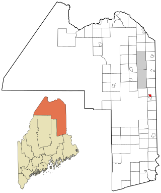
Lincoln County is a county located in the U.S. state of Maine. As of the 2020 census, the population was 35,237. Its seat is Wiscasset. The county was founded in 1760 by the Massachusetts General Court from a portion of York County, Massachusetts and named after the English city Lincoln, the birthplace of Massachusetts Bay Provincial Governor Thomas Pownall.

Damariscotta is a town in Lincoln County, Maine, United States. The population was 2,297 at the 2020 census. Damariscotta is the oyster capital of New England. A popular tourist destination, the towns of Damariscotta and Newcastle are linked by the Main Street bridge over the Damariscotta River, forming the "Twin Villages". The name Damariscotta derives from a native place-name meaning place of abundance of small fish (alewives).
Damariscotta-Newcastle was a census-designated place (CDP) in Lincoln County, Maine, United States. It designated a concentration of population around where the most developed portions of the towns of Damariscotta and Newcastle meet, generally corresponding to the "Twin Villages" area. As of the 2000 census, the CDP population was 1,751. For the 2010 census, the area was delineated as two separate CDPs, Damariscotta and Newcastle.

Jefferson is a town in Lincoln County, Maine, United States. The population was 2,551 at the 2020 census. Damariscotta Lake State Park, a popular Mid Coast swimming, canoeing and picnic area, is located within the town limits.

Newcastle is a town in Lincoln County, Maine, United States. The population was 1,848 at the 2020 census. The village of Newcastle is located in the eastern part of the town, on the Damariscotta River. Together with the village of Damariscotta linked by the Main Street bridge, they form the Twin Villages.

South Bristol is a town in Lincoln County, Maine, United States. The population was 1,127 at the 2020 census. A fishing and resort area, South Bristol includes the villages of Walpole and Christmas Cove, the latter on Rutherford Island. The town has six nature preserves.

Bristol is a census-designated place (CDP) and the main village in the town of Bristol in Grafton County, New Hampshire, United States. The population of the CDP was 1,911 at the 2020 census, out of 3,244 in the entire town.

Steep Falls is a census-designated place (CDP) in the town of Standish in Cumberland County, Maine, United States. The population was 1,139 at the 2010 census. It is part of the Portland–South Portland–Biddeford, Maine Metropolitan Statistical Area. The town is part of Maine School Administrative District #6, which includes Bonny Eagle Middle and High Schools.

Fort Fairfield is a census-designated place (CDP) comprising the main village within the town of Fort Fairfield in Aroostook County, Maine, United States. The population of the CDP was 1,825 at the 2010 census, out of a population of 3,496 for the entire town.

Farmington is a census-designated place (CDP) comprising the center of the town of Farmington, which is the county seat of Franklin County in Maine, United States. The population of the CDP was 4,288 at the 2010 census, out of 7,760 people in the town as a whole. The University of Maine at Farmington is located within the CDP.
Mars Hill is a census-designated place (CDP) comprising the main village within the town of Mars Hill in Aroostook County, Maine, United States. The population of the CDP was 980 at the 2010 census, out of a population of 1,493 for the entire town. Prior to 2010, the village was part of the Mars Hill-Blaine CDP.
Blue Hill is a census-designated place (CDP) in the town of Blue Hill in Hancock County, Maine, United States. The CDP population was 943 as per the 2010 census, out of a population of 2,686 in the town of Blue Hill as a whole.
Southwest Harbor is a census-designated place (CDP) in the town of Southwest Harbor in Hancock County, Maine, United States. The CDP population was 720 at the 2010 census, out of 1,764 people in the town as a whole.
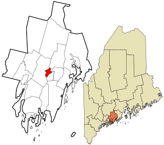
Newcastle is a census-designated place (CDP) comprising the main village of the town of Newcastle in Lincoln County, Maine, United States. The population was 667 at the 2010 census, out of 1,752 in the entire town. In the 2000 census, the village was part of the Damariscotta-Newcastle CDP.

State Route 130 (SR 130) is part of Maine's system of numbered state highways, located in southern Lincoln. It is one of several routes which dead-end on the Atlantic coast at their southern ends. The southern terminus of SR 130 is at Pemaquid Point in Bristol, at the intersection of Bristol Road and Pemaquid Loop Road. The northern terminus is located at U.S. Route 1 Business in Damariscotta, an end it shares with SR 129. It runs for 14.41 miles (23.19 km).

Oakland is a census-designated place (CDP) comprising the main population center in the town of Oakland in Kennebec County, Maine, United States. The population was 2,602 at the 2010 census, out of 6,240 in the entire town of Oakland.

Winthrop is a census-designated place (CDP) comprising the primary settlement in the town of Winthrop in Kennebec County, Maine, United States. The population was 2,650 at the 2010 census, out of 6,092 in the town of Winthrop as a whole.

Boothbay Harbor is a census-designated place (CDP) comprising the densely populated center of the town of Boothbay Harbor in Lincoln County, Maine, United States. The population was 1,086 at the 2010 census, down from 1,237 at the 2000 census.

Waldoboro is a census-designated place (CDP) comprising the central village in the town of Waldoboro in Lincoln County, Maine, United States. The population was 1,300 at the 2020 census, out of 5,075 people in the entire town of Waldoboro.

Wiscasset is a census-designated place (CDP) comprising the primary settlement in the town of Wiscasset in Lincoln County, Maine, United States. The population was 1,232 at the 2020 census, out of 3,732 people in the entire town. Wiscasset is the county seat of Lincoln County.

