Burnaby is a city in British Columbia, Canada, located immediately to the east of Vancouver. It is the third-largest city in British Columbia by population, surpassed only by nearby Surrey and Vancouver.

The Yellowhead Highway is a major interprovincial highway in Western Canada that runs from Winnipeg to Graham Island off the coast of British Columbia via Saskatoon and Edmonton. It stretches across the four western Canadian provinces of British Columbia, Alberta, Saskatchewan, and Manitoba and is part of the Trans-Canada Highway system and the larger National Highway System, but should not be confused with the more southerly, originally-designated Trans-Canada Highway. The highway was officially opened in 1970. Beginning in 1990, the green and white Trans-Canada logo was used to designate the roadway.
Highway 17 is a system of two separate highways: One on Vancouver Island, the other on the Lower Mainland, connected by a ferry link.
Highway 99, also known as the Fraser Delta Thruway south of Vancouver, and the Sea to Sky Highway, the Squamish Highway, or Whistler Highway north of Vancouver, is the major north–south artery running through the Greater Vancouver area of British Columbia from the U.S. border, up Howe Sound through the Sea to Sky Country to Lillooet, and connecting to Highway 97 just north of Cache Creek. The number of this highway is derived from the old U.S. Route 99, with which the highway originally connected. The highway currently connects with Interstate 5 at the international border.
Highway 99A was the designation of Highway 99's original 1942 alignment. It has had the '99A' designation between 1962 and 1964, and from 1973 to 2006 when it was decommissioned, although as of 2017 commercially published road maps still show it.

Highway 15 (BC 15), known locally as the Pacific Highway, is a 20.99-kilometre-long (13.04 mi) north–south highway primarily located in the City of Surrey, British Columbia. The southern terminus is with Interstate 5 (I-5) near Blaine, Washington as Washington State Route 543 (SR 543). SR 543 is a 1.09-mile-long (1.75 km) connector between I-5 and the Canada–US border, linking with BC 15. Over 3,000 trucks per day pass through the border crossing along SR 543 and BC 15, because the Peace Arch border crossing does not allow commercial trucks.

Highway 111 is a 13-kilometre (8 mi) controlled-access freeway in Halifax Regional Municipality, Nova Scotia, Canada.

Alberta Provincial Highway No. 16, commonly referred to as Highway 16, is a major east–west highway in central Alberta, Canada, connecting Jasper to Lloydminster via Edmonton. It forms a portion of the Yellowhead Highway, a major interprovincial route of the Trans-Canada Highway system that stretches from Masset, British Columbia to Portage la Prairie, Manitoba, near Winnipeg. Highway 16 spans approximately 634 km (394 mi) from Alberta's border with British Columbia in the west to its border with Saskatchewan in the east. As of 2010, all but less than 96 km (60 mi) of the route was divided, with a minimum of two lanes in each direction. It is designated a core route in Canada's National Highway System.
Kingsway is a major thoroughfare that crosses through the Canadian cities of Vancouver and Burnaby, British Columbia. The road runs diagonally from northwest to southeast, emerging from Vancouver's Main Street just south of East 7th Avenue and becoming 12th Street at the Burnaby–New Westminster border.

The 99 B-Line is an express bus line with bus rapid transit elements in Metro Vancouver, British Columbia, Canada. It travels along Broadway, a major east-west thoroughfare, and connects the University of British Columbia (UBC) to Commercial–Broadway station on the SkyTrain system. It is operated by Coast Mountain Bus Company and funded by TransLink.

Victoria–Fraserview is a neighbourhood in the City of Vancouver, set on the south slope of the rise that runs north from the Fraser River and encompassing a large area of residential and commercial development. Surrounding the culturally eclectic Victoria Drive corridor, Victoria–Fraserview is an ethnically diverse area that was one of the earliest areas of settlement in the region.

Georgia Street is an east–west street in the cities of Vancouver and Burnaby, British Columbia, Canada. Its section in Downtown Vancouver, designated West Georgia Street, serves as one of the primary streets for the financial and central business districts, and is the major transportation corridor connecting downtown Vancouver with the North Shore by way of the Lions Gate Bridge. The remainder of the street, known as East Georgia Street between Main Street and Boundary Road and simply Georgia Street within Burnaby, is more residential in character, and is discontinuous at several points.

Hastings Street is one of the most important east-west traffic corridors in the cities of Vancouver and Burnaby, British Columbia, Canada, and used to be a part of the decommissioned Highway 7A. In the central business district of Downtown Vancouver it is known as West Hastings Street; at Carrall Street it becomes East Hastings Street and runs eastwards through East Vancouver and Burnaby. In Burnaby, there is no east-west designation. The street ends in Westridge, a neighbourhood at the foot of Burnaby Mountain where it joins the recently built Burnaby Mountain Parkway and diverges from the continuation of the former Highway 7A as the Barnet Highway, to Port Moody, British Columbia.
Burnaby Mountain Parkway is a major road in Burnaby, British Columbia, Canada. It runs across Burnaby Mountain and connects Hastings Street leading west to Downtown Vancouver and Inlet Drive that becomes Barnet Highway leading east to Port Moody, Simon Fraser University (SFU), the City of Coquitlam, and other eastern suburbs.

Broadway is a major east-west thoroughfare in the city of Vancouver, British Columbia, Canada. In Vancouver's numbered avenue grid system, it runs in place of a 9th Avenue, between 8th and 10th. The street has six lanes for most of its course. Portions of the street carry the British Columbia Highway 7 designation.
Oak Street is a major north-south street in Vancouver, British Columbia, Canada. The street begins in the north at an intersection with 6th Avenue in the Fairview neighbourhood and continues to the Oak Street Bridge in the south, leading towards Richmond. There is a small portion west of the bridge that is in the industrial area of Vancouver along the Fraser River From its intersection with 70th Avenue southwards, the route is a component section of Highway 99, except for the aforementioned industrial section.

The 95 B-Line is an express bus line with bus rapid transit elements in Metro Vancouver, Canada. It replaced the 135 Express bus that traveled along Hastings Street, a major east-west route, and connects Simon Fraser University to Burrard station on the SkyTrain system.

Mayfield Road, 111 Avenue , and 112 Avenue is a major arterial road in north Edmonton, Alberta. It serves Edmonton's Northwest Industrial District, the old town of Jasper Place, the inner city north Downtown Edmonton, and post-World War II Edmonton. Prior to the opening of Yellowhead Trail in the early 1980s, Highway 16 followed Mayfield Road and 111 Avenue between Stony Plain Road and 109 Street.
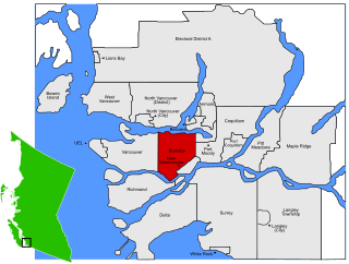
Burnaby South is a federal electoral district in British Columbia. It encompasses a portion of British Columbia previously included in the electoral districts of Burnaby—Douglas and Burnaby—New Westminster.


