Redwood Meadows Golf & Country Club is a semi-private golf club located in the Townsite of Redwood Meadows on the Tsuu T'ina First Nation, 25 kilometres (16 mi) west of Calgary, Alberta, Canada. The golf course was the host of the Nationwide Tour's Alberta Classic in 2004 and 2005.
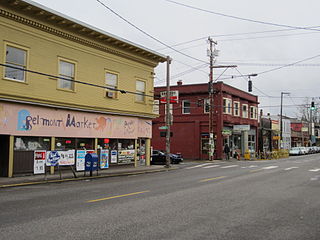
The Belmont Area is a retail and residential district running along SE Belmont St. in the inner Southeast section of Portland, Oregon in a parallel fashion to the Hawthorne District, 6 blocks to the south. From west to east the area extends 48 blocks, from SE 12th Ave. to SE 60th Ave., passing through the Buckman, Sunnyside, and Mount Tabor neighborhoods. The area is seven blocks wide, running from SE Belmont St. 4 blocks north to SE Stark St. and 3 blocks south to SE Salmon St. SE Belmont St. between SE 33rd Ave. and SE 35th Ave., in Sunnyside, is the heart of the district.
The Giltspur Street Compter was a compter or small prison, mainly used to hold debtors. It was situated in Giltspur Street, Smithfield, close to Newgate, in the City of London, between 1791 and 1853.
Bescot is an area of Walsall in the West Midlands of England. It is served by Bescot Stadium railway station, adjacent to which is Bescot depot where locomotives are maintained. The Banks's Stadium was built in 1990 for Walsall F.C. The area is bisected by the M6 motorway, including its 'Junction 9', where it meets the A461 which leads to Pleck and Wednesbury. The River Tame also runs through the area.
St. Michel Arena is a 2,000-seat indoor arena in Montreal, Quebec, Canada that was built in 1968. It served as the weightlifting venue of the 1976 Summer Olympics and is located about 4.4 km west of the Olympic Stadium. The capacity was temporarily raised to 2,700 for the games.

Longview Baptist Temple, often abbreviated LBT, is an Independent Fundamental Baptist (IFB) [ Formed in 1960, it has been at its present location since 1971. The church has a bus ministry which services the cities of Longview, Gladewater, Kilgore, and Tyler.

The Roxy is a bar and nightclub in central London, United Kingdom. It is located at the Tottenham Court Road end of Oxford Street. The Roxy attracts a predominantly younger crowd and is particularly popular with University College London students on Wednesday night.

The European route E 1 is a series of roads in Europe, part of the United Nations International E-road network, running from Larne, United Kingdom to Seville, Spain. There is a sea crossing between Rosslare Harbour, in Ireland, and Ferrol, but no ferry service. The road also passes through Portugal – past the city of Porto, through the capital, Lisbon, and then south to the Algarve, passing Faro before reaching the Spanish border west of Huelva.

Merevale Hall is a private country house in Merevale, near Atherstone, Warwickshire. It is a Grade II* listed building. The estate descends from Merevale Abbey which once stood on the site.

Greek National Road 51 is a single carriageway road in northeastern Greece. It connects the Greek National Road 2 near Feres with the Bulgarian border near Ormenio. The main towns on the GR-51 are Didymoteicho and Orestiada. The entire GR-51 is part of the European route E85. Its length is about 128 km. It runs from south to north, parallel to the river Evros.

Cavendish Square is a public square in the West End of London, very close to Oxford Circus, where the two main shopping thoroughfares of Oxford Street and Regent Street meet. It is located at the eastern end of Wigmore Street, which connects it to Portman Square, part of the Portman Estate, to its west. One side is faced by the rear of the flagship John Lewis shop.

Le Boullay-Mivoye is a commune in the Eure-et-Loir department in northern France.
Carampoma District is one of thirty-two districts of the province Huarochirí in Peru.
Saterna is a village in the Tiéfora Department of Comoé Province in south-western Burkina Faso. The village has a population of 388.

Pratappur is a village development committee in Nawalparasi District in the Lumbini Zone of southern Nepal. At the time of the 1991 Nepal census it had a population of 5654 people living in 889 individual households.

Volodymyr Dahl East Ukrainian National University (SNU) is one of the leading establishments of higher education in Ukraine. It was founded in 1920, and in 1991 it was named after Vladimir Dal. It was the first higher educational establishment in which specialists in machine-building were trained. During World War II the institute was evacuated to Omsk (Russia). There it became the basis for the foundation of Omsk State Technical University.

Elan Village is a small purpose-built community in Powys, Wales. It was designed by architect Herbert Tudor Buckland as part of Birmingham Corporation's scheme to construct a series of water supply reservoirs in the Elan Valley between 1892 and 1904. It housed workers and their families responsible for maintaining the scheme's dams and the filtration systems. Elan Village is the only purpose-built Arts and Crafts "Model Village" in Wales.
Wiang Kalong is a village and tambon (subdistrict) of Wiang Pa Pao District, in Chiang Rai Province, Thailand. In 2005 it had a total population of 9,572 people. The tambon contains 15 villages.

Royal Naval Cemetery is a cemetery on the Isle of Portland, Dorset, England. The site overlooks Portland Harbour, and is found below the main entrance to the Verne Citadel. As the name suggests, the graveyard holds deceased servicemen and officers of Portland's Royal Navy which was stationed at the island until 1995. The cemetery holds 140 identified casualties in total to date, and is owned by the Ministry of Defence.

Groß Flottbek, is a quarter of Hamburg, Germany, in the borough of Altona. It is located in the center of the borough north of the Othmarschen quarter. Near Groß Flottbek, the neighbourhood of Klein Flottbek, which is not an official quarter, can be found. Around 11.000 people live in Groß Flottbek on 2.4 sq km.


