A village is a clustered human settlement or community, larger than a hamlet but smaller than a town, with a population ranging from a few hundred to a few thousand. Though villages are often located in rural areas, the term urban village is also applied to certain urban neighborhoods. Villages are normally permanent, with fixed dwellings; however, transient villages can occur. Further, the dwellings of a village are fairly close to one another, not scattered broadly over the landscape, as a dispersed settlement.

Plainfield is a village in Will County, Illinois, United States. The population is estimated to be 42,183 as of 2015.

Adrien Brody is an American actor and producer. He received widespread recognition and acclaim after starring in Roman Polanski's The Pianist (2002), for which he won the Academy Award for Best Actor at age twenty-nine, making him the youngest actor to win in that category. Brody is also the only male American actor to receive the César Award for Best Actor.

The Village is a 2004 American psychological thriller mystery drama film, written, produced, and directed by M. Night Shyamalan, and starring Joaquin Phoenix, Adrien Brody, Bryce Dallas Howard, William Hurt, Sigourney Weaver, and Brendan Gleeson. The film is about a village whose inhabitants live in fear of creatures inhabiting the woods beyond it, referred to as "Those We Don't Speak Of". Like other films written and directed by Shyamalan from the same time period, The Village has a twist ending.

Ayot St Lawrence is a small village and civil parish in Hertfordshire, between Harpenden and Welwyn. There are several other Ayots in the area, including Ayot Green and Ayot St Peter, where the census population of Ayot St Lawrence was included in 2011.

Gadap Town is a town in the northwestern part of Karachi with the Hub River on its western limits also forming the provincial border between Sindh and Balochistan, while to the north and east are Jamshoro District and the Kirthar Mountains.
The administrative divisions of India are subnational administrative units of India; they compose a nested hierarchy of country subdivisions. Indian states and territories frequently use different local titles for the same level of subdivision.

Tilley is a hamlet in southern Alberta, Canada. It is located within the County of Newell approximately 22 km southeast of the City of Brooks and 78 km northwest of the City of Medicine Hat.

Malmsjøen is a lake in the municipality of Skaun in Trøndelag county, Norway. It is located about 1.5 kilometres (0.93 mi) southeast of the village of Skaun, about 7 kilometres (4.3 mi) north of the village of Korsvegen, and about 10 kilometres (6.2 mi) southwest of the village of Melhus. The Norwegian County Road 709 runs along the northern shore of the lake.

Ramapur village and post, or Rama Pur as it is known for postal purposes is a village-gram panchayat in Pawai Block, Phulpur, Azamgarh, Uttar Pradesh, India comprising five villages located on the Sultanpur-Azamgarh road.

Usborne No. 310, Saskatchewan, is a rural municipality of 566 rural residents in the central part of Saskatchewan, Canada. The RM was incorporated December 13, 1909. Other localities in the area include Guernsey, Drake, Lanigan and Venn.

Naganur is a village in the southern state of Karnataka, India. It is located in the Gokak taluk of Belgaum district in Karnataka.

Caspar Headlands State Beach is a protected beach in the state park system of California, USA. It is located in Northern California in Mendocino County near the village of Caspar. The 75-acre (30 ha) park was established in 1972.
Tarihal is a village in Belgaum district of Karnataka, India.

Thakurganj railway station serves Thakurganj town in Kishanganj district in the Indian state of Bihar. The Mechi flowing nearby forms the boundary between Nepal and India in the area. On the other side of the border, Prithivinagar is a village development committee in Jhapa District of Nepal.
Walajabad taluk is a taluk in the Kanchipuram district of Tamil Nadu, India. At the 2011 Census of India, the taluk covered an area of 339.03 square kilometres (130.90 sq mi) with a population of 125,868. The headquarters of the taluk is the town of Walajabad.

The western al-Bab offensive was a military operation launched by the Syrian Democratic Forces (SDF) against the Islamic State of Iraq and the Levant in the countryside of northwestern Aleppo Governorate, south of the towns of Mare' and Tel Rifaat.
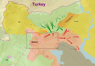
The East Aleppo offensive (2017), also referred to as the Dayr Hafir offensive (2017), was an operation launched by the Syrian Army to prevent Turkish-backed rebel forces from advancing deeper into Syria, and also to ultimately capture the ISIL stronghold of Dayr Hafir. Another aim of the operation was to gain control of the water source for Aleppo city, at the Khafsa Water Treatment Plant, in addition to capturing the Jirah Military Airbase. At the same time, the Turkish-backed rebel groups turned towards the east and started launching attacks against the Syrian Democratic Forces, west of Manbij.