
Greenwood is a town in Vernon County, Wisconsin, United States. The population was 770 at the 2000 census. The unincorporated community of Greenwood is located in the town.
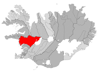
Borgarnes is a town located on a peninsula at the shore of Borgarfjörður in Iceland and is the largest town in the Borgarbyggð municipality with a population of about 3750 residents. It is a main junction in Iceland and the gateway to the Snaefellsnes National Park. Iceland's capital Reykjavik is 69 kilometers from the center of Borgarnes. The second largest bridge in Iceland, the Borgarfjarðarbrú, connects traffic to and from Reykjavik.

Ardfield, historically Ardofoyle, is a small village on the southwest coast of County Cork, Ireland. It lies between Clonakilty and Rosscarbery, near Galley Head. According to the 2010 Census, Ardfield had a population of 1,070. Ardfield is part of the Roman Catholic parish of Ardfield/Rathbarry.

Kukawa is a town and Local Government Area in the northeastern Nigerian state of Borno, close to Lake Chad.

Rio Oja is a river in the La Rioja province of northern Spain. It flows through the Oja Valley past the town and municipality of Ezcaray. It is generally accepted to have given its name to the famous wine of the Rioja DO, although there are other theories. The Oja flows into the Tirón River east of Cihuri, and the Tirón flows into the Ebro immediately north of Haro.

Uszód is a village in Bács-Kiskun county, in the Southern Great Plain region of southern Hungary.

Rápolt is a village in Szabolcs-Szatmár-Bereg county, in the Northern Great Plain region of eastern Hungary.
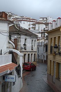
Periana is a town and municipality in the province of Málaga, part of the autonomous community of Andalusia in southern Spain. It belongs to the comarca of La Axarquía. The municipality is situated approximately 23 kilometres from Vélez and 48 from the provincial capital of Málaga near the Sierra de Alhama. It has a population of approximately 3,500 residents. The natives are called Perianenses and their nickname is Los Manga Anchas or “The Wide-sleeved Ones”. The Sierra de Alhama
Villar del Ala is a municipality located in the province of Soria, Castile and León, Spain. According to the 2004 census (INE), the municipality has a population of 57 inhabitants.

Pijijiapan is a town and municipality in the Mexican state of Chiapas, on the coast of the Pacific Ocean about midway between the border with the state of Oaxaca and the international frontier with Guatemala.
Diassara is a town in the Iolonioro Department of Bougouriba Province in south-western Burkina Faso. The town has a population of 2,083.
Mangagou is a town in the Zabré Department of Boulgou Province in south-eastern Burkina Faso. As of 2005, the town has a population of 1,030.

Scânteia is a commune located in Ialomița County, Romania. It is composed of two villages, Iazu and Scânteia.
Scânteia is a commune in Iași County, Romania. It is composed of seven villages: Bodești, Boroșești, Ciocârlești, Lunca Rateș, Rediu, Scânteia and Tufeștii de Sus.

Manakamana is a village development committee in Gorkha District in the Gandaki Zone of northern-central Nepal. At the time of the 1991 Nepal census it had a population of 5,083 and had 889 houses in the town.

Sikasso Cercle is one of seven administrative subdivision of the Sikasso Region of southern Mali. The capital is the town of Sikasso.

Cambuci is a district in the city of São Paulo, Brazil.
Kotlentsi is a village in the municipality of Dobrichka, in Dobrich Province, in northeastern Bulgaria.
Mečkovac is a village in the municipality of Vranje, Serbia. According to the 2002 census, the village has a population of 169 people.

Lamerton is a village and civil parish located 3 miles north-west of the town of Tavistock in Devon, England. The village's school is called Lamerton Church of England Voluntary Controlled Primary School; affiliated with the Church of England, it enrols about 50 children aged 5–11.


