| Brandon | |
|---|---|
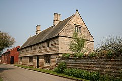 Brandon Old Hall | |
 Chapel of Ease, dedicated to St. John the Evangelist | |
 Brandon Location within Lincolnshire | |
| OS grid reference | SK904482 |
| • London | 107 mi (172 km) S |
| District | |
| Shire county | |
| Region | |
| Country | England |
| Sovereign state | United Kingdom |
| Post town | GRANTHAM |
| Postcode district | NG32 |
| Dialling code | 01636 |
| Police | Lincolnshire |
| Fire | Lincolnshire |
| Ambulance | East Midlands |
| UK Parliament | |
Brandon is a small village in South Kesteven, south Lincolnshire, England, part of the civil parish of Hough-on-the-Hill (where the population is listed).
Contents
The village is also part of the ecclesiastical parish of Hough on the Hill, part of the Loveden Deanery of the Diocese of Lincoln. There is a chapel of ease dedicated to St John the Evangelist, [1] linked to the main church at Hough.